VOTING POWER100.00%
DOWNVOTE POWER100.00%
RESOURCE CREDITS100.00%
REPUTATION PROGRESS0.00%
Net Worth
0.007USD
STEEM
0.000STEEM
SBD
0.000SBD
Effective Power
5.001SP
├── Own SP
0.124SP
└── Incoming DelegationsDeleg
+4.877SP
Detailed Balance
| STEEM | ||
| balance | 0.000STEEM | STEEM |
| market_balance | 0.000STEEM | STEEM |
| savings_balance | 0.000STEEM | STEEM |
| reward_steem_balance | 0.000STEEM | STEEM |
| STEEM POWER | ||
| Own SP | 0.124SP | SP |
| Delegated Out | 0.000SP | SP |
| Delegation In | 4.877SP | SP |
| Effective Power | 5.001SP | SP |
| Reward SP (pending) | 0.000SP | SP |
| SBD | ||
| sbd_balance | 0.000SBD | SBD |
| sbd_conversions | 0.000SBD | SBD |
| sbd_market_balance | 0.000SBD | SBD |
| savings_sbd_balance | 0.000SBD | SBD |
| reward_sbd_balance | 0.000SBD | SBD |
{
  "balance": "0.000 STEEM",
  "savings_balance": "0.000 STEEM",
  "reward_steem_balance": "0.000 STEEM",
  "vesting_shares": "202.525893 VESTS",
  "delegated_vesting_shares": "0.000000 VESTS",
  "received_vesting_shares": "7941.133913 VESTS",
  "sbd_balance": "0.000 SBD",
  "savings_sbd_balance": "0.000 SBD",
  "reward_sbd_balance": "0.000 SBD",
  "conversions": []
}
Account Info
| name | aedyn |
| id | 1103474 |
| rank | 251,016 |
| reputation | 78892882 |
| created | 2018-08-14T16:00:45 |
| recovery_account | steem |
| proxy | None |
| post_count | 5 |
| comment_count | 0 |
| lifetime_vote_count | 0 |
| witnesses_voted_for | 0 |
| last_post | 2019-02-02T16:28:30 |
| last_root_post | 2019-02-02T16:28:30 |
| last_vote_time | 2019-02-02T16:34:33 |
| proxied_vsf_votes | 0, 0, 0, 0 |
| can_vote | 1 |
| voting_power | 0 |
| delayed_votes | 0 |
| balance | 0.000 STEEM |
| savings_balance | 0.000 STEEM |
| sbd_balance | 0.000 SBD |
| savings_sbd_balance | 0.000 SBD |
| vesting_shares | 202.525893 VESTS |
| delegated_vesting_shares | 0.000000 VESTS |
| received_vesting_shares | 7941.133913 VESTS |
| reward_vesting_balance | 0.000000 VESTS |
| vesting_balance | 0.000 STEEM |
| vesting_withdraw_rate | 0.000000 VESTS |
| next_vesting_withdrawal | 1969-12-31T23:59:59 |
| withdrawn | 0 |
| to_withdraw | 0 |
| withdraw_routes | 0 |
| savings_withdraw_requests | 0 |
| last_account_recovery | 1970-01-01T00:00:00 |
| reset_account | null |
| last_owner_update | 1970-01-01T00:00:00 |
| last_account_update | 2018-08-17T12:46:18 |
| mined | No |
| sbd_seconds | 0 |
| sbd_last_interest_payment | 1970-01-01T00:00:00 |
| savings_sbd_last_interest_payment | 1970-01-01T00:00:00 |
{
  "id": 1103474,
  "name": "aedyn",
  "owner": {
    "weight_threshold": 1,
    "account_auths": [],
    "key_auths": [
      [
        "STM7BHNV6cpiWoDyC2Jw2YxbGrZ8XA52W8Kot4bVvwCqJ3b4sUXvL",
        1
      ]
    ]
  },
  "active": {
    "weight_threshold": 1,
    "account_auths": [],
    "key_auths": [
      [
        "STM8GfudXSh7EnvoE3xNGTs3pWyyyTWoH6cwvaQoCerMWbMR1V8Sv",
        1
      ]
    ]
  },
  "posting": {
    "weight_threshold": 1,
    "account_auths": [],
    "key_auths": [
      [
        "STM5XzXj511CwZ2oY9StcprsTNCShLrjV6PWN977pmPvQANMVasK6",
        1
      ]
    ]
  },
  "memo_key": "STM4zsWoVnrKG5cBhJYzGoCvjj47ajpD8fcN9JnTgmzZ6F9bshFvS",
  "json_metadata": "{\"profile\":{\"name\":\"DharmaBrothers\"}}",
  "posting_json_metadata": "{\"profile\":{\"name\":\"DharmaBrothers\"}}",
  "proxy": "",
  "last_owner_update": "1970-01-01T00:00:00",
  "last_account_update": "2018-08-17T12:46:18",
  "created": "2018-08-14T16:00:45",
  "mined": false,
  "recovery_account": "steem",
  "last_account_recovery": "1970-01-01T00:00:00",
  "reset_account": "null",
  "comment_count": 0,
  "lifetime_vote_count": 0,
  "post_count": 5,
  "can_vote": true,
  "voting_manabar": {
    "current_mana": "8143659806",
    "last_update_time": 1779051390
  },
  "downvote_manabar": {
    "current_mana": 2035914951,
    "last_update_time": 1779051390
  },
  "voting_power": 0,
  "balance": "0.000 STEEM",
  "savings_balance": "0.000 STEEM",
  "sbd_balance": "0.000 SBD",
  "sbd_seconds": "0",
  "sbd_seconds_last_update": "1970-01-01T00:00:00",
  "sbd_last_interest_payment": "1970-01-01T00:00:00",
  "savings_sbd_balance": "0.000 SBD",
  "savings_sbd_seconds": "0",
  "savings_sbd_seconds_last_update": "1970-01-01T00:00:00",
  "savings_sbd_last_interest_payment": "1970-01-01T00:00:00",
  "savings_withdraw_requests": 0,
  "reward_sbd_balance": "0.000 SBD",
  "reward_steem_balance": "0.000 STEEM",
  "reward_vesting_balance": "0.000000 VESTS",
  "reward_vesting_steem": "0.000 STEEM",
  "vesting_shares": "202.525893 VESTS",
  "delegated_vesting_shares": "0.000000 VESTS",
  "received_vesting_shares": "7941.133913 VESTS",
  "vesting_withdraw_rate": "0.000000 VESTS",
  "next_vesting_withdrawal": "1969-12-31T23:59:59",
  "withdrawn": 0,
  "to_withdraw": 0,
  "withdraw_routes": 0,
  "curation_rewards": 0,
  "posting_rewards": 0,
  "proxied_vsf_votes": [
    0,
    0,
    0,
    0
  ],
  "witnesses_voted_for": 0,
  "last_post": "2019-02-02T16:28:30",
  "last_root_post": "2019-02-02T16:28:30",
  "last_vote_time": "2019-02-02T16:34:33",
  "post_bandwidth": 0,
  "pending_claimed_accounts": 0,
  "vesting_balance": "0.000 STEEM",
  "reputation": 78892882,
  "transfer_history": [],
  "market_history": [],
  "post_history": [],
  "vote_history": [],
  "other_history": [],
  "witness_votes": [],
  "tags_usage": [],
  "guest_bloggers": [],
  "rank": 251016
}
Withdraw Routes
| Incoming | Outgoing |
|---|---|
Empty | Empty |
{
  "incoming": [],
  "outgoing": []
}From Date
To Date
2026/05/17 20:56:30
2026/05/17 20:56:30
| delegator | steem |
| delegatee | aedyn |
| vesting shares | 7941.133913 VESTS |
| Transaction Info | Block #106139490/Trx 137900ee19789903f180727af9437d9172335de7 |
View Raw JSON Data
{
  "trx_id": "137900ee19789903f180727af9437d9172335de7",
  "block": 106139490,
  "trx_in_block": 1,
  "op_in_trx": 0,
  "virtual_op": 0,
  "timestamp": "2026-05-17T20:56:30",
  "op": [
    "delegate_vesting_shares",
    {
      "delegator": "steem",
      "delegatee": "aedyn",
      "vesting_shares": "7941.133913 VESTS"
    }
  ]
}2026/05/11 16:33:45
2026/05/11 16:33:45
| delegator | steem |
| delegatee | aedyn |
| vesting shares | 5228.923508 VESTS |
| Transaction Info | Block #105962216/Trx 8e1f8dd93a2029ba167a0c9e0ad11910eb9d1997 |
View Raw JSON Data
{
  "trx_id": "8e1f8dd93a2029ba167a0c9e0ad11910eb9d1997",
  "block": 105962216,
  "trx_in_block": 5,
  "op_in_trx": 0,
  "virtual_op": 0,
  "timestamp": "2026-05-11T16:33:45",
  "op": [
    "delegate_vesting_shares",
    {
      "delegator": "steem",
      "delegatee": "aedyn",
      "vesting_shares": "5228.923508 VESTS"
    }
  ]
}2026/04/25 20:22:27
2026/04/25 20:22:27
| delegator | steem |
| delegatee | aedyn |
| vesting shares | 7953.649669 VESTS |
| Transaction Info | Block #105507235/Trx e43a92348a4ab62c8e4d0f52c15ffcc7596f00b5 |
View Raw JSON Data
{
  "trx_id": "e43a92348a4ab62c8e4d0f52c15ffcc7596f00b5",
  "block": 105507235,
  "trx_in_block": 0,
  "op_in_trx": 0,
  "virtual_op": 0,
  "timestamp": "2026-04-25T20:22:27",
  "op": [
    "delegate_vesting_shares",
    {
      "delegator": "steem",
      "delegatee": "aedyn",
      "vesting_shares": "7953.649669 VESTS"
    }
  ]
}2026/01/22 22:56:15
2026/01/22 22:56:15
| delegator | steem |
| delegatee | aedyn |
| vesting shares | 5270.470327 VESTS |
| Transaction Info | Block #102841196/Trx a873aff9f943481ae689fea85ff41799af7251b0 |
View Raw JSON Data
{
  "trx_id": "a873aff9f943481ae689fea85ff41799af7251b0",
  "block": 102841196,
  "trx_in_block": 1,
  "op_in_trx": 0,
  "virtual_op": 0,
  "timestamp": "2026-01-22T22:56:15",
  "op": [
    "delegate_vesting_shares",
    {
      "delegator": "steem",
      "delegatee": "aedyn",
      "vesting_shares": "5270.470327 VESTS"
    }
  ]
}2024/12/16 18:17:27
2024/12/16 18:17:27
| delegator | steem |
| delegatee | aedyn |
| vesting shares | 5434.689524 VESTS |
| Transaction Info | Block #91287645/Trx 0ff21945732b34a34ffeb3f97157bb54f55cb256 |
View Raw JSON Data
{
  "trx_id": "0ff21945732b34a34ffeb3f97157bb54f55cb256",
  "block": 91287645,
  "trx_in_block": 0,
  "op_in_trx": 0,
  "virtual_op": 0,
  "timestamp": "2024-12-16T18:17:27",
  "op": [
    "delegate_vesting_shares",
    {
      "delegator": "steem",
      "delegatee": "aedyn",
      "vesting_shares": "5434.689524 VESTS"
    }
  ]
}2023/11/13 10:03:42
2023/11/13 10:03:42
| delegator | steem |
| delegatee | aedyn |
| vesting shares | 5603.823056 VESTS |
| Transaction Info | Block #79841934/Trx 5130cca1233e9204f4d1c207482a747e915cfdeb |
View Raw JSON Data
{
  "trx_id": "5130cca1233e9204f4d1c207482a747e915cfdeb",
  "block": 79841934,
  "trx_in_block": 2,
  "op_in_trx": 0,
  "virtual_op": 0,
  "timestamp": "2023-11-13T10:03:42",
  "op": [
    "delegate_vesting_shares",
    {
      "delegator": "steem",
      "delegatee": "aedyn",
      "vesting_shares": "5603.823056 VESTS"
    }
  ]
}2023/09/21 17:55:48
2023/09/21 17:55:48
| delegator | steem |
| delegatee | aedyn |
| vesting shares | 8541.101842 VESTS |
| Transaction Info | Block #78343168/Trx 36fc983df4fa45a5212ebcd07b0adaaf3718c1f9 |
View Raw JSON Data
{
  "trx_id": "36fc983df4fa45a5212ebcd07b0adaaf3718c1f9",
  "block": 78343168,
  "trx_in_block": 1,
  "op_in_trx": 0,
  "virtual_op": 0,
  "timestamp": "2023-09-21T17:55:48",
  "op": [
    "delegate_vesting_shares",
    {
      "delegator": "steem",
      "delegatee": "aedyn",
      "vesting_shares": "8541.101842 VESTS"
    }
  ]
}2022/11/03 08:11:06
2022/11/03 08:11:06
| delegator | steem |
| delegatee | aedyn |
| vesting shares | 8762.783280 VESTS |
| Transaction Info | Block #69109056/Trx bb49bcceae985fe4c0b9240c3809622c8a19879f |
View Raw JSON Data
{
  "trx_id": "bb49bcceae985fe4c0b9240c3809622c8a19879f",
  "block": 69109056,
  "trx_in_block": 2,
  "op_in_trx": 0,
  "virtual_op": 0,
  "timestamp": "2022-11-03T08:11:06",
  "op": [
    "delegate_vesting_shares",
    {
      "delegator": "steem",
      "delegatee": "aedyn",
      "vesting_shares": "8762.783280 VESTS"
    }
  ]
}2022/01/17 07:46:21
2022/01/17 07:46:21
| delegator | steem |
| delegatee | aedyn |
| vesting shares | 8983.316511 VESTS |
| Transaction Info | Block #60805616/Trx 7840d704fa52270b558f5f71c3b05f88911ff315 |
View Raw JSON Data
{
  "trx_id": "7840d704fa52270b558f5f71c3b05f88911ff315",
  "block": 60805616,
  "trx_in_block": 7,
  "op_in_trx": 0,
  "virtual_op": 0,
  "timestamp": "2022-01-17T07:46:21",
  "op": [
    "delegate_vesting_shares",
    {
      "delegator": "steem",
      "delegatee": "aedyn",
      "vesting_shares": "8983.316511 VESTS"
    }
  ]
}2021/06/13 21:49:36
2021/06/13 21:49:36
| delegator | steem |
| delegatee | aedyn |
| vesting shares | 9167.085169 VESTS |
| Transaction Info | Block #54604166/Trx c00242e99751d0db5c544479ab1d8d980711e6f7 |
View Raw JSON Data
{
  "trx_id": "c00242e99751d0db5c544479ab1d8d980711e6f7",
  "block": 54604166,
  "trx_in_block": 2,
  "op_in_trx": 0,
  "virtual_op": 0,
  "timestamp": "2021-06-13T21:49:36",
  "op": [
    "delegate_vesting_shares",
    {
      "delegator": "steem",
      "delegatee": "aedyn",
      "vesting_shares": "9167.085169 VESTS"
    }
  ]
}2020/12/11 08:12:57
2020/12/11 08:12:57
| delegator | steem |
| delegatee | aedyn |
| vesting shares | 9354.507143 VESTS |
| Transaction Info | Block #49351752/Trx a7707f587d93862682fda5ece4117ade2ec0125c |
View Raw JSON Data
{
  "trx_id": "a7707f587d93862682fda5ece4117ade2ec0125c",
  "block": 49351752,
  "trx_in_block": 33,
  "op_in_trx": 0,
  "virtual_op": 0,
  "timestamp": "2020-12-11T08:12:57",
  "op": [
    "delegate_vesting_shares",
    {
      "delegator": "steem",
      "delegatee": "aedyn",
      "vesting_shares": "9354.507143 VESTS"
    }
  ]
}2020/12/06 01:50:18
2020/12/06 01:50:18
| delegator | steem |
| delegatee | aedyn |
| vesting shares | 1912.543513 VESTS |
| Transaction Info | Block #49203319/Trx 6d66e6fb8425e198bed5b22d02b6a6be692d6426 |
View Raw JSON Data
{
  "trx_id": "6d66e6fb8425e198bed5b22d02b6a6be692d6426",
  "block": 49203319,
  "trx_in_block": 1,
  "op_in_trx": 0,
  "virtual_op": 0,
  "timestamp": "2020-12-06T01:50:18",
  "op": [
    "delegate_vesting_shares",
    {
      "delegator": "steem",
      "delegatee": "aedyn",
      "vesting_shares": "1912.543513 VESTS"
    }
  ]
}2020/11/25 14:41:09
2020/11/25 14:41:09
| delegator | steem |
| delegatee | aedyn |
| vesting shares | 9371.633760 VESTS |
| Transaction Info | Block #48906377/Trx 664a54885cbfc9c91997dc52c73c3d869dee5208 |
View Raw JSON Data
{
  "trx_id": "664a54885cbfc9c91997dc52c73c3d869dee5208",
  "block": 48906377,
  "trx_in_block": 7,
  "op_in_trx": 0,
  "virtual_op": 0,
  "timestamp": "2020-11-25T14:41:09",
  "op": [
    "delegate_vesting_shares",
    {
      "delegator": "steem",
      "delegatee": "aedyn",
      "vesting_shares": "9371.633760 VESTS"
    }
  ]
}2020/05/09 02:44:54
2020/05/09 02:44:54
| delegator | steem |
| delegatee | aedyn |
| vesting shares | 9563.520356 VESTS |
| Transaction Info | Block #43213533/Trx a1efe9df94abbc8772a0cf93f535192311676733 |
View Raw JSON Data
{
  "trx_id": "a1efe9df94abbc8772a0cf93f535192311676733",
  "block": 43213533,
  "trx_in_block": 5,
  "op_in_trx": 0,
  "virtual_op": 0,
  "timestamp": "2020-05-09T02:44:54",
  "op": [
    "delegate_vesting_shares",
    {
      "delegator": "steem",
      "delegatee": "aedyn",
      "vesting_shares": "9563.520356 VESTS"
    }
  ]
}2020/05/08 05:53:30
2020/05/08 05:53:30
| delegator | steem |
| delegatee | aedyn |
| vesting shares | 1953.311140 VESTS |
| Transaction Info | Block #43189088/Trx 7cc0d3c3c6b275e00deba571677594f4976cfc73 |
View Raw JSON Data
{
  "trx_id": "7cc0d3c3c6b275e00deba571677594f4976cfc73",
  "block": 43189088,
  "trx_in_block": 31,
  "op_in_trx": 0,
  "virtual_op": 0,
  "timestamp": "2020-05-08T05:53:30",
  "op": [
    "delegate_vesting_shares",
    {
      "delegator": "steem",
      "delegatee": "aedyn",
      "vesting_shares": "1953.311140 VESTS"
    }
  ]
}2020/04/07 00:07:42
2020/04/07 00:07:42
| delegator | steem |
| delegatee | aedyn |
| vesting shares | 9581.070528 VESTS |
| Transaction Info | Block #42312346/Trx 56f52255cc32b34c4b963debbf70f68d8b300e51 |
View Raw JSON Data
{
  "trx_id": "56f52255cc32b34c4b963debbf70f68d8b300e51",
  "block": 42312346,
  "trx_in_block": 30,
  "op_in_trx": 0,
  "virtual_op": 0,
  "timestamp": "2020-04-07T00:07:42",
  "op": [
    "delegate_vesting_shares",
    {
      "delegator": "steem",
      "delegatee": "aedyn",
      "vesting_shares": "9581.070528 VESTS"
    }
  ]
}2019/08/14 17:57:09
2019/08/14 17:57:09
| parent author | aedyn |
| parent permlink | chaos-den |
| author | steemitboard |
| permlink | steemitboard-notify-aedyn-20190814t175709000z |
| title | |
| body | Congratulations @aedyn! You received a personal award! <table><tr><td>https://steemitimages.com/70x70/http://steemitboard.com/@aedyn/birthday1.png</td><td>Happy Birthday! - You are on the Steem blockchain for 1 year!</td></tr></table> <sub>_You can view [your badges on your Steem Board](https://steemitboard.com/@aedyn) and compare to others on the [Steem Ranking](https://steemitboard.com/ranking/index.php?name=aedyn)_</sub> ###### [Vote for @Steemitboard as a witness](https://v2.steemconnect.com/sign/account-witness-vote?witness=steemitboard&approve=1) to get one more award and increased upvotes! |
| json metadata | {"image":["https://steemitboard.com/img/notify.png"]} |
| Transaction Info | Block #35551541/Trx 9ac8e428cc08a8e2a616d652e3602930cb809771 |
View Raw JSON Data
{
  "trx_id": "9ac8e428cc08a8e2a616d652e3602930cb809771",
  "block": 35551541,
  "trx_in_block": 10,
  "op_in_trx": 0,
  "virtual_op": 0,
  "timestamp": "2019-08-14T17:57:09",
  "op": [
    "comment",
    {
      "parent_author": "aedyn",
      "parent_permlink": "chaos-den",
      "author": "steemitboard",
      "permlink": "steemitboard-notify-aedyn-20190814t175709000z",
      "title": "",
      "body": "Congratulations @aedyn! You received a personal award!\n\n<table><tr><td>https://steemitimages.com/70x70/http://steemitboard.com/@aedyn/birthday1.png</td><td>Happy Birthday! - You are on the Steem blockchain for 1 year!</td></tr></table>\n\n<sub>_You can view [your badges on your Steem Board](https://steemitboard.com/@aedyn) and compare to others on the [Steem Ranking](https://steemitboard.com/ranking/index.php?name=aedyn)_</sub>\n\n\n###### [Vote for @Steemitboard as a witness](https://v2.steemconnect.com/sign/account-witness-vote?witness=steemitboard&approve=1) to get one more award and increased upvotes!",
      "json_metadata": "{\"image\":[\"https://steemitboard.com/img/notify.png\"]}"
    }
  ]
}2019/05/04 16:38:03
2019/05/04 16:38:03
| delegator | steem |
| delegatee | aedyn |
| vesting shares | 9776.752022 VESTS |
| Transaction Info | Block #32617257/Trx 579e94ce7124c9b1da105cd1d0fe4fa05c7a931f |
View Raw JSON Data
{
  "trx_id": "579e94ce7124c9b1da105cd1d0fe4fa05c7a931f",
  "block": 32617257,
  "trx_in_block": 8,
  "op_in_trx": 0,
  "virtual_op": 0,
  "timestamp": "2019-05-04T16:38:03",
  "op": [
    "delegate_vesting_shares",
    {
      "delegator": "steem",
      "delegatee": "aedyn",
      "vesting_shares": "9776.752022 VESTS"
    }
  ]
}2019/02/26 07:48:27
2019/02/26 07:48:27
| parent author | aedyn |
| parent permlink | chaos-den |
| author | partiko |
| permlink | partiko-re-aedyn-chaos-den-20190226t074827112z |
| title | |
| body | Hello @aedyn! This is a friendly reminder that you have 3000 Partiko Points unclaimed in your Partiko account! Partiko is a fast and beautiful mobile app for Steem, and it’s the most popular Steem mobile app out there! Download Partiko using the link below and login using SteemConnect to claim your 3000 Partiko points! You can easily convert them into Steem token! https://partiko.app/referral/partiko  |
| json metadata | {"app":"partiko"} |
| Transaction Info | Block #30679888/Trx 21b4eadd5769ca7b7ea48eb4dce1895153dd4b9b |
View Raw JSON Data
{
"trx_id": "21b4eadd5769ca7b7ea48eb4dce1895153dd4b9b",
"block": 30679888,
"trx_in_block": 18,
"op_in_trx": 0,
"virtual_op": 0,
"timestamp": "2019-02-26T07:48:27",
"op": [
"comment",
{
"parent_author": "aedyn",
"parent_permlink": "chaos-den",
"author": "partiko",
"permlink": "partiko-re-aedyn-chaos-den-20190226t074827112z",
"title": "",
"body": "Hello @aedyn! This is a friendly reminder that you have 3000 Partiko Points unclaimed in your Partiko account!\n\nPartiko is a fast and beautiful mobile app for Steem, and it’s the most popular Steem mobile app out there! Download Partiko using the link below and login using SteemConnect to claim your 3000 Partiko points! You can easily convert them into Steem token!\n\nhttps://partiko.app/referral/partiko\n\n",
"json_metadata": "{\"app\":\"partiko\"}"
}
]
}2019/02/02 17:25:03
2019/02/02 17:25:03
| delegator | steem |
| delegatee | aedyn |
| vesting shares | 29892.720330 VESTS |
| Transaction Info | Block #30000767/Trx c8a1d69d99482ad90bae8ff54fedf093cea31244 |
View Raw JSON Data
{
  "trx_id": "c8a1d69d99482ad90bae8ff54fedf093cea31244",
  "block": 30000767,
  "trx_in_block": 24,
  "op_in_trx": 0,
  "virtual_op": 0,
  "timestamp": "2019-02-02T17:25:03",
  "op": [
    "delegate_vesting_shares",
    {
      "delegator": "steem",
      "delegatee": "aedyn",
      "vesting_shares": "29892.720330 VESTS"
    }
  ]
}2019/02/02 16:34:33
2019/02/02 16:34:33
| voter | aedyn |
| author | aedyn |
| permlink | chaos-den |
| weight | 10000 (100.00%) |
| Transaction Info | Block #29999758/Trx dddced80c3f237e6d95e01f94cb17f0dca97507f |
View Raw JSON Data
{
  "trx_id": "dddced80c3f237e6d95e01f94cb17f0dca97507f",
  "block": 29999758,
  "trx_in_block": 0,
  "op_in_trx": 0,
  "virtual_op": 0,
  "timestamp": "2019-02-02T16:34:33",
  "op": [
    "vote",
    {
      "voter": "aedyn",
      "author": "aedyn",
      "permlink": "chaos-den",
      "weight": 10000
    }
  ]
}2019/02/02 16:30:42
2019/02/02 16:30:42
| parent author | |
| parent permlink | photography |
| author | aedyn |
| permlink | chaos-den |
| title | [Photographs Collection] "Chaos' Den" by Adrien Jacquier Bret |
| body | This collection is about nature's disorder perception. The chaos of interweaved branches and brambles appears to draw a dark and deep den, where light and space are engaged in a fascinating struggle. The horror we see in a place that is commonly considered as inhospitable conveys the idea of something offensive and harmful, but yet, full of endless beauties, that carries to our eyes something dangerous but attractive, the only home we've ever known, chaos' den. All photographs are mine, taken by myself and protected under the copyright license. Copyright © 2018 Adrien Jacquier Bret All rights reserved. 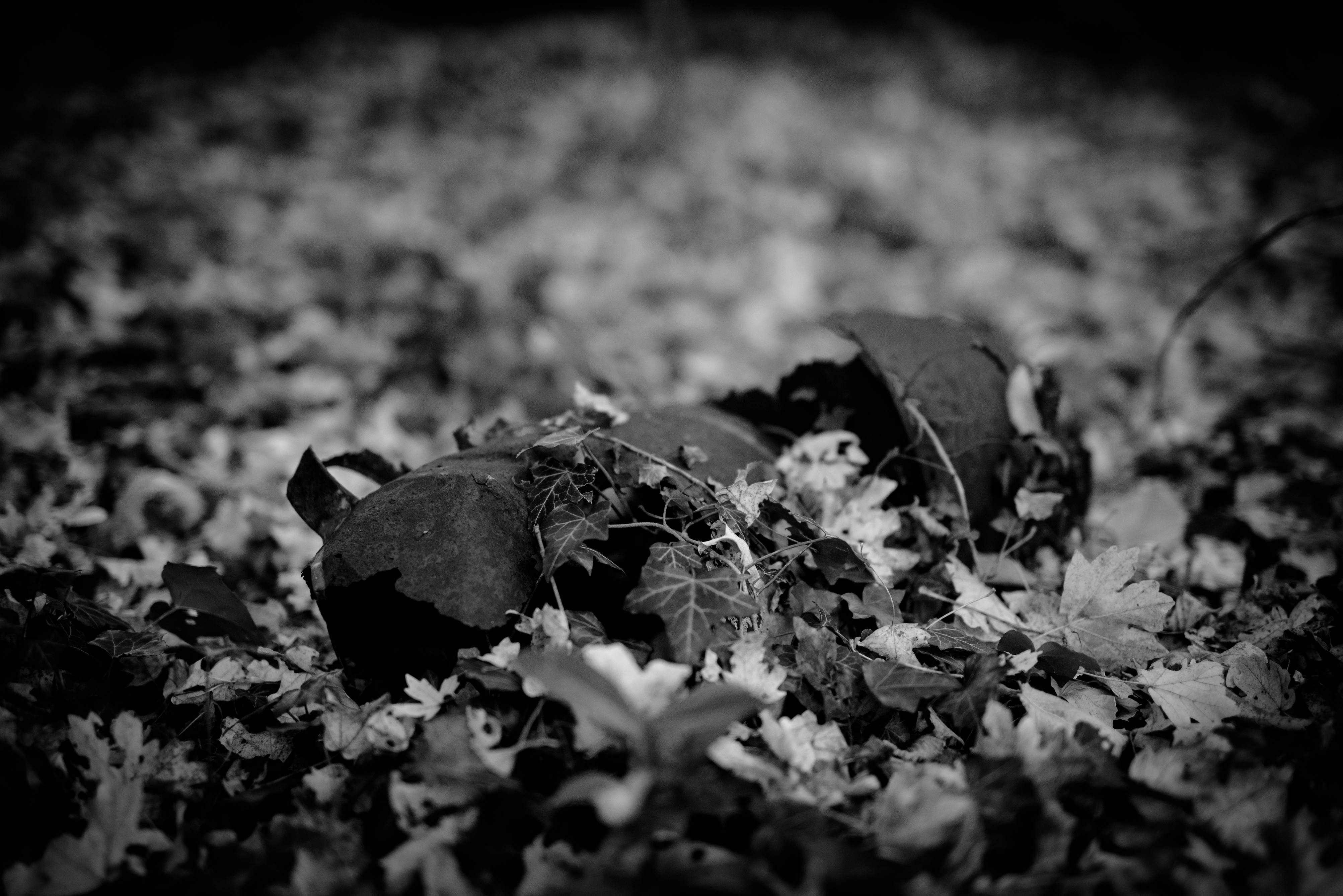 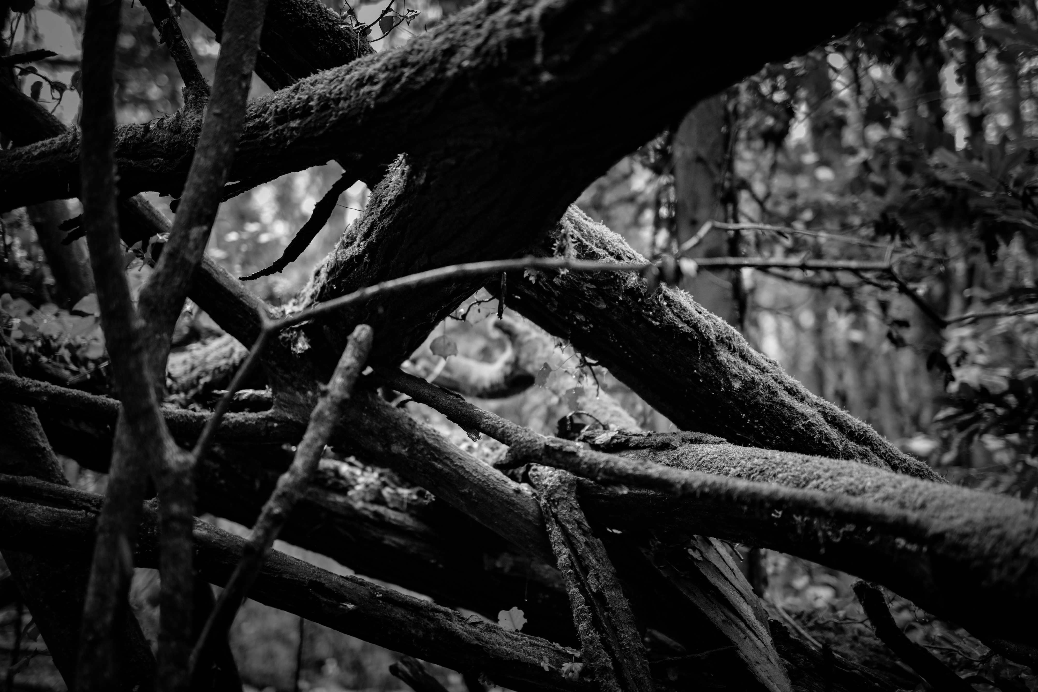 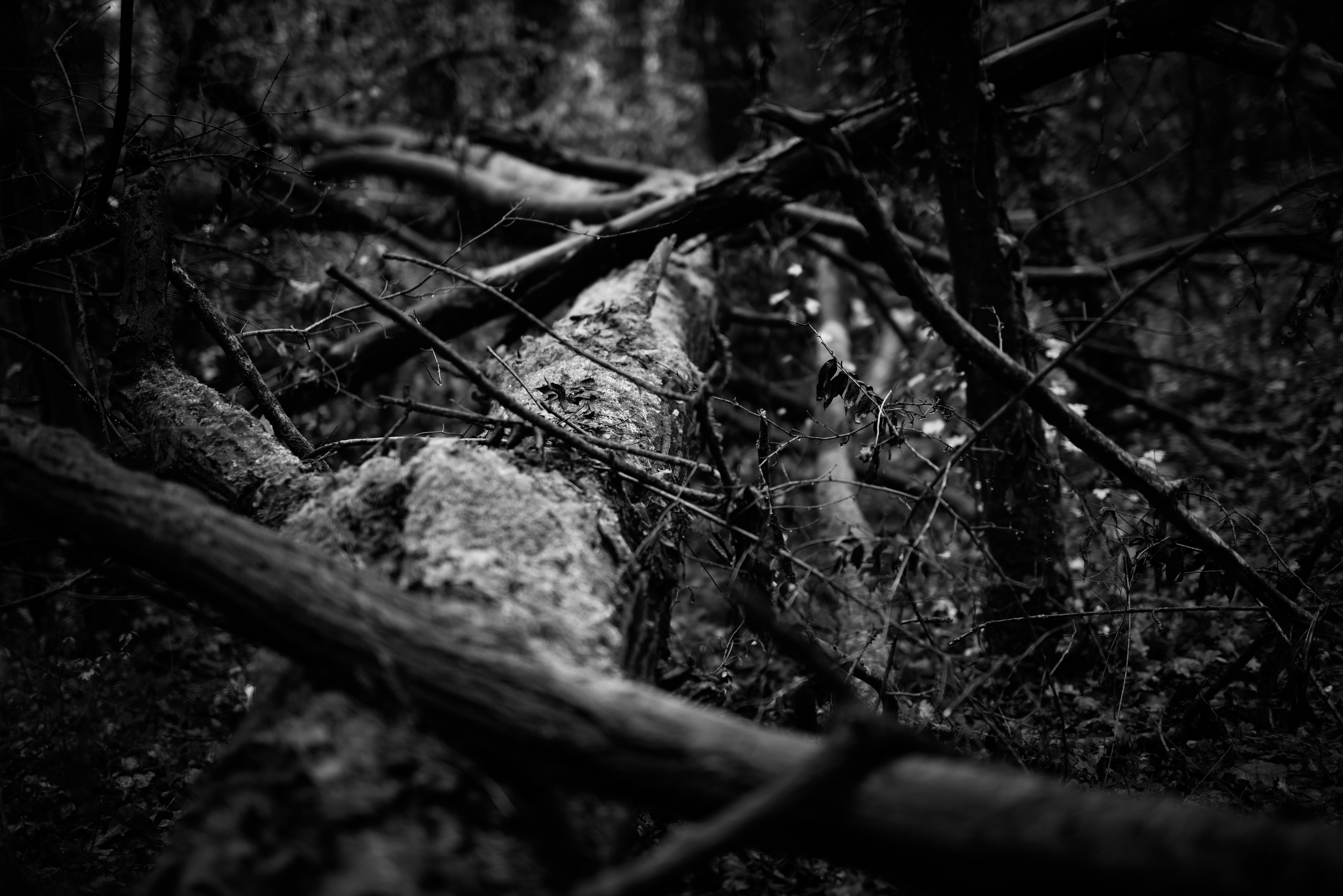 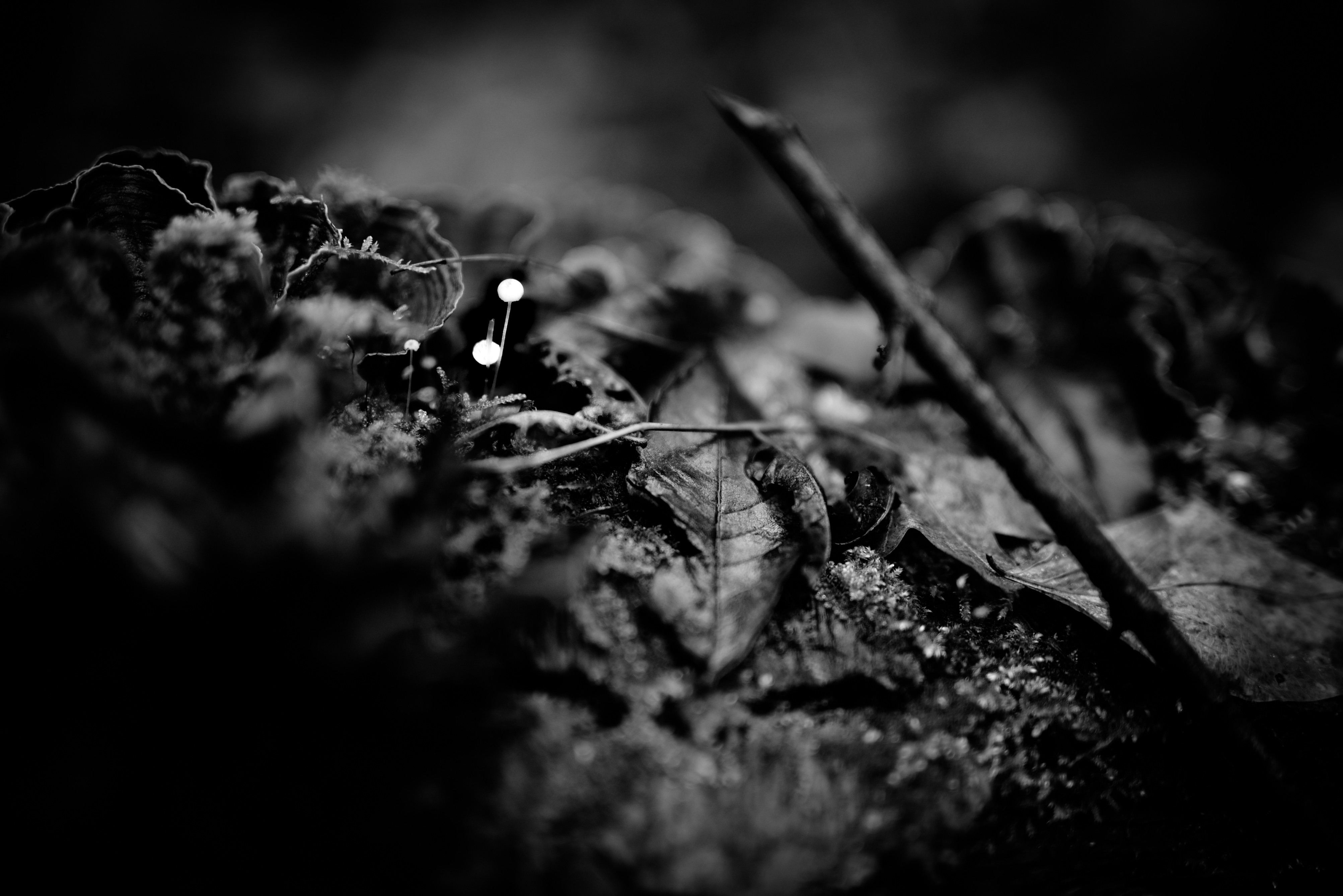 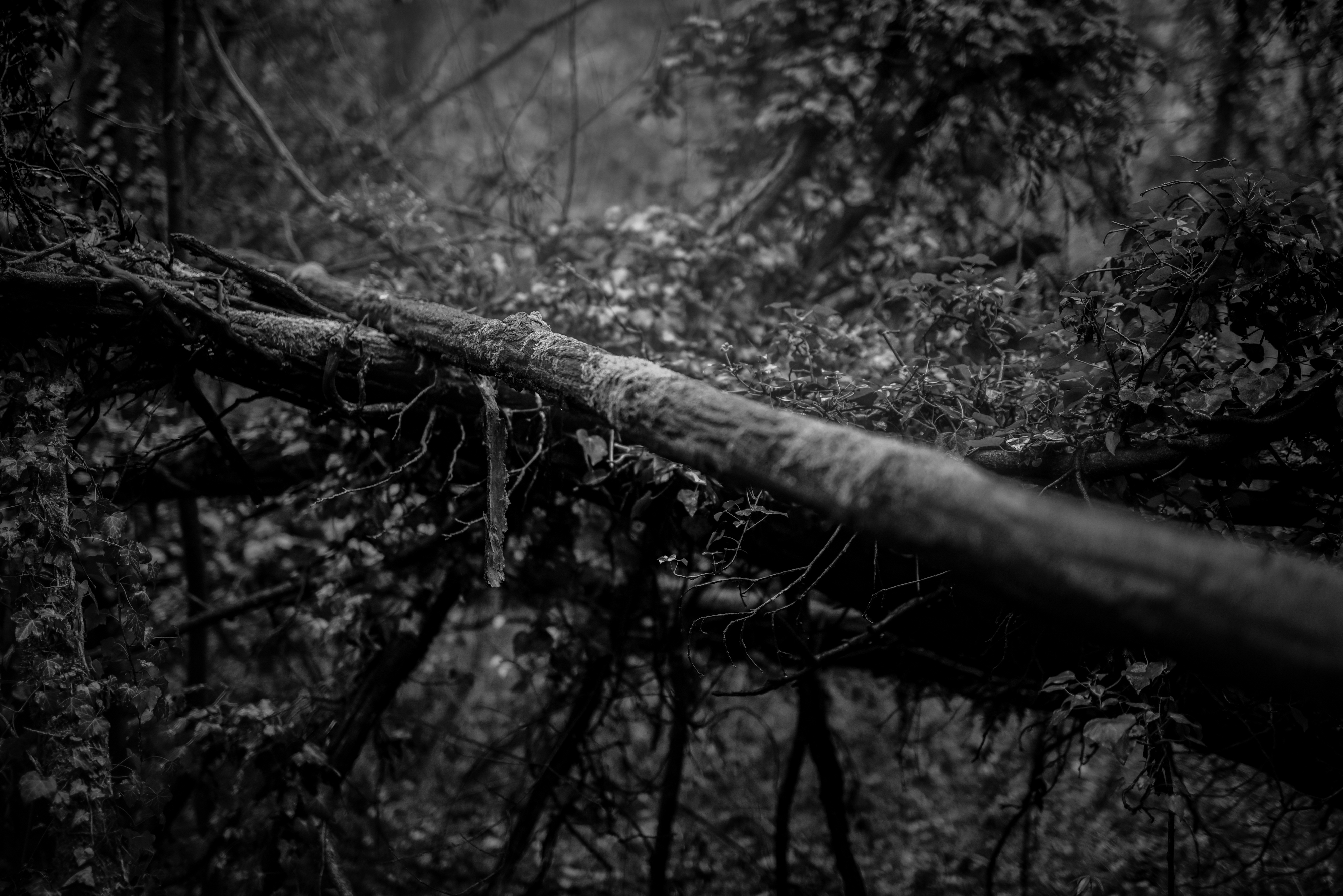 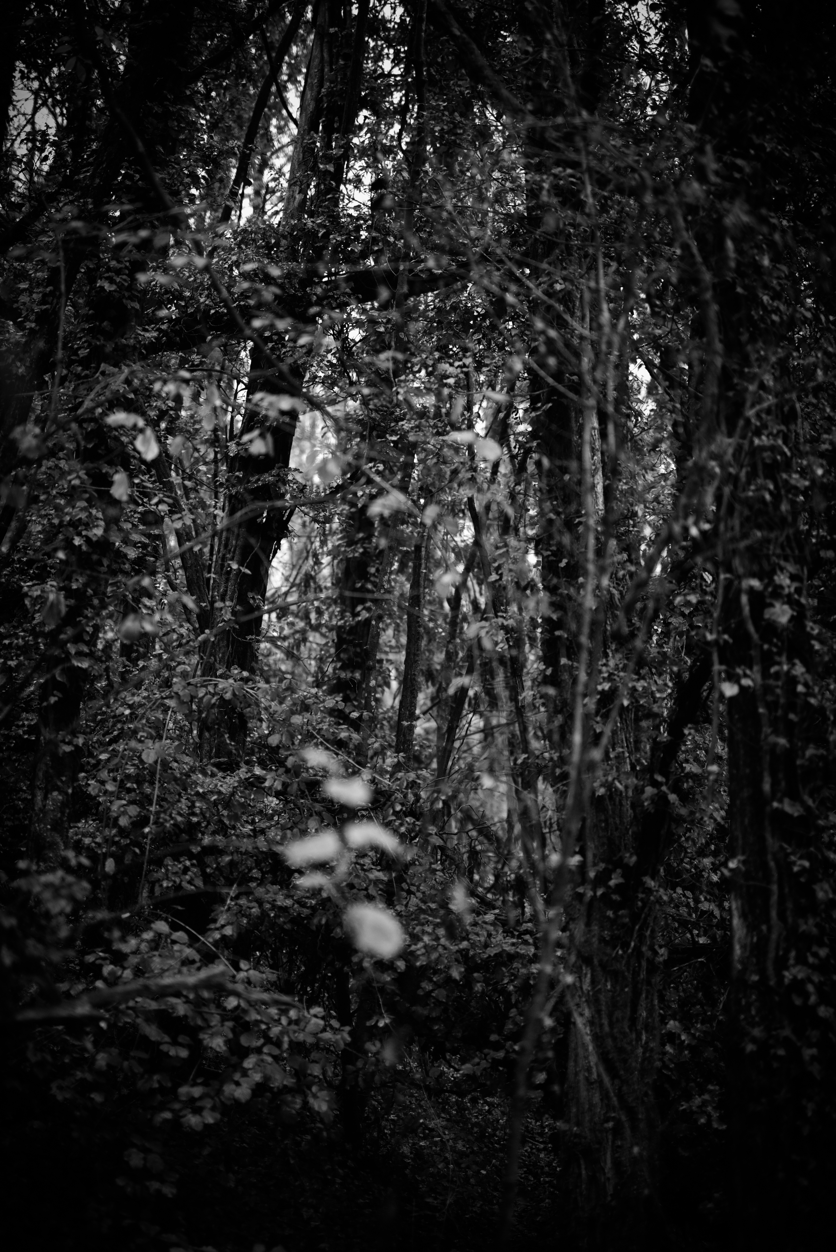 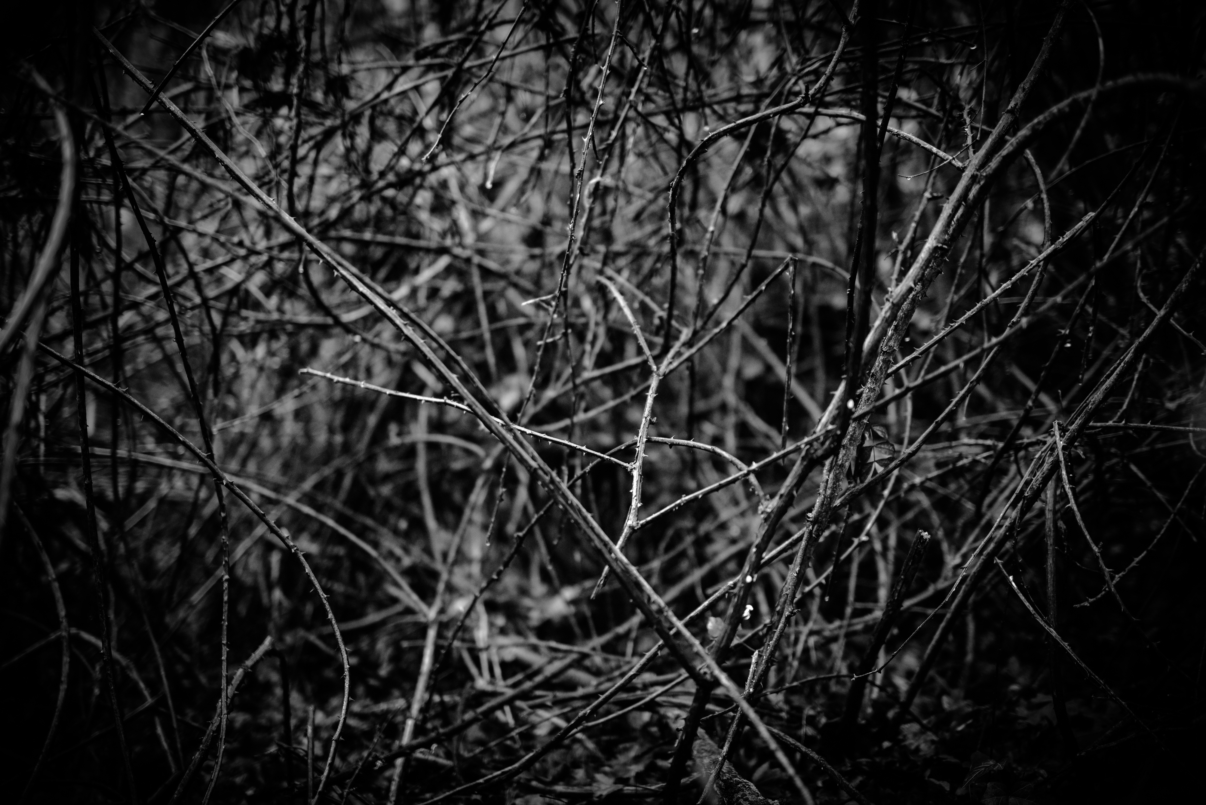 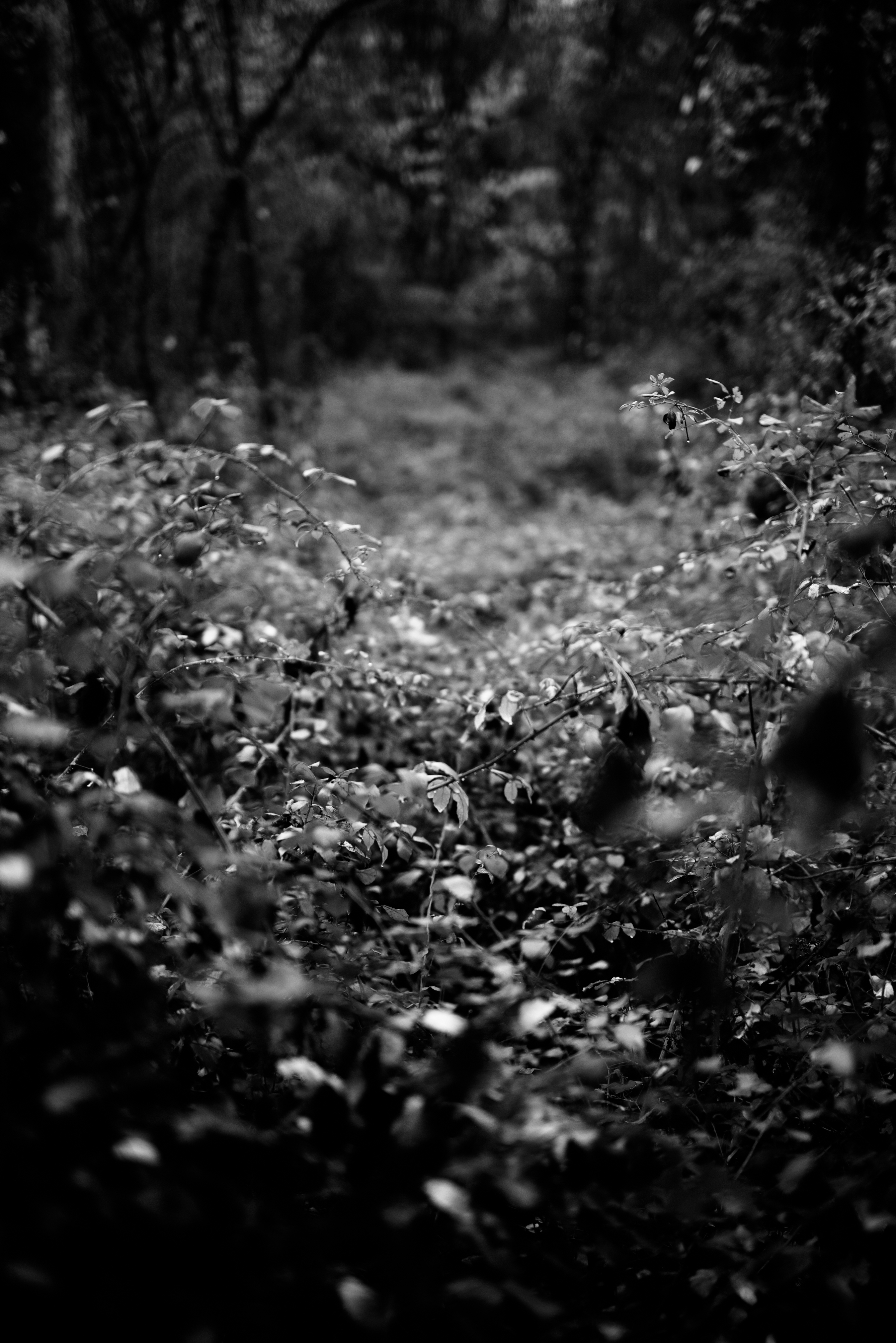  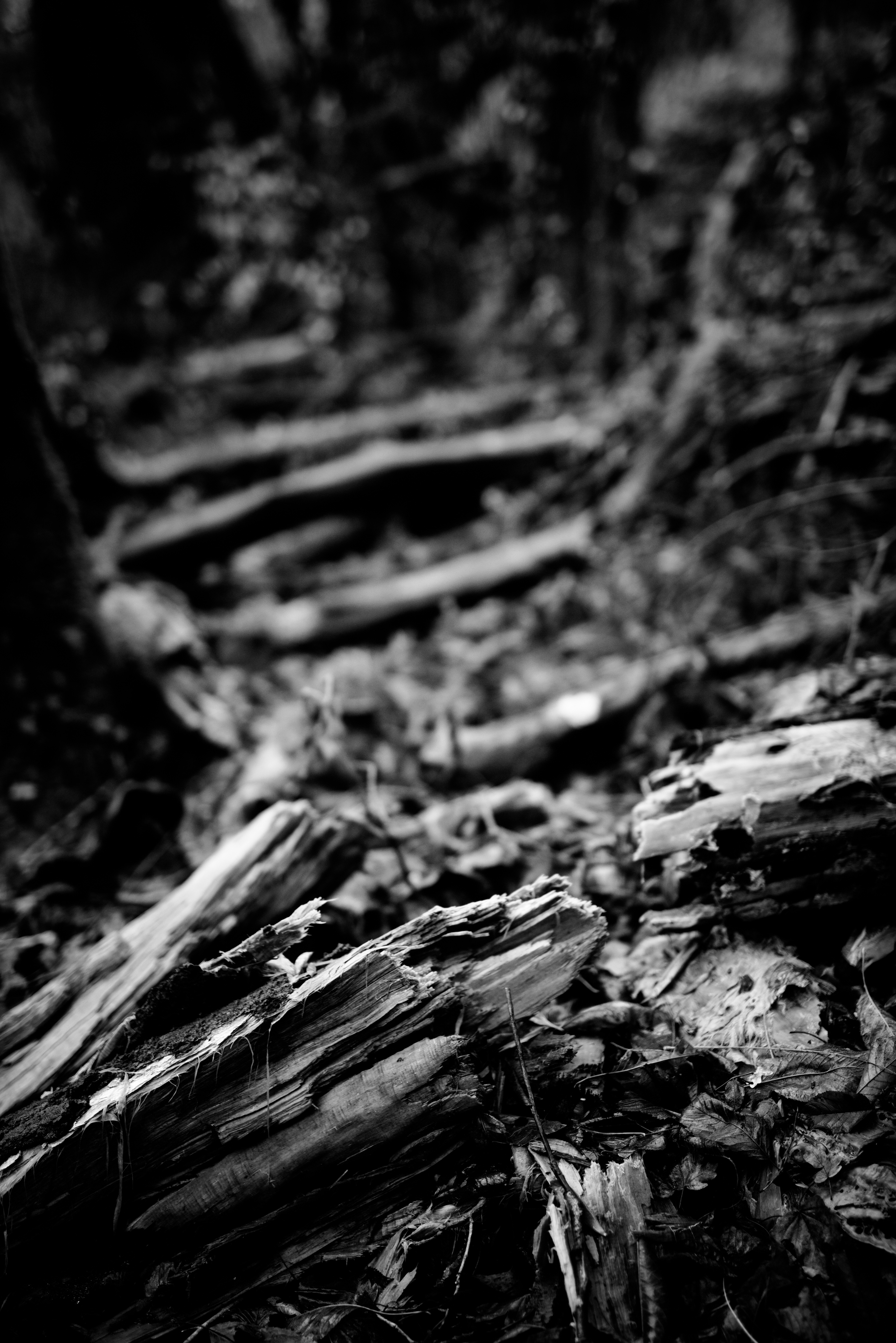 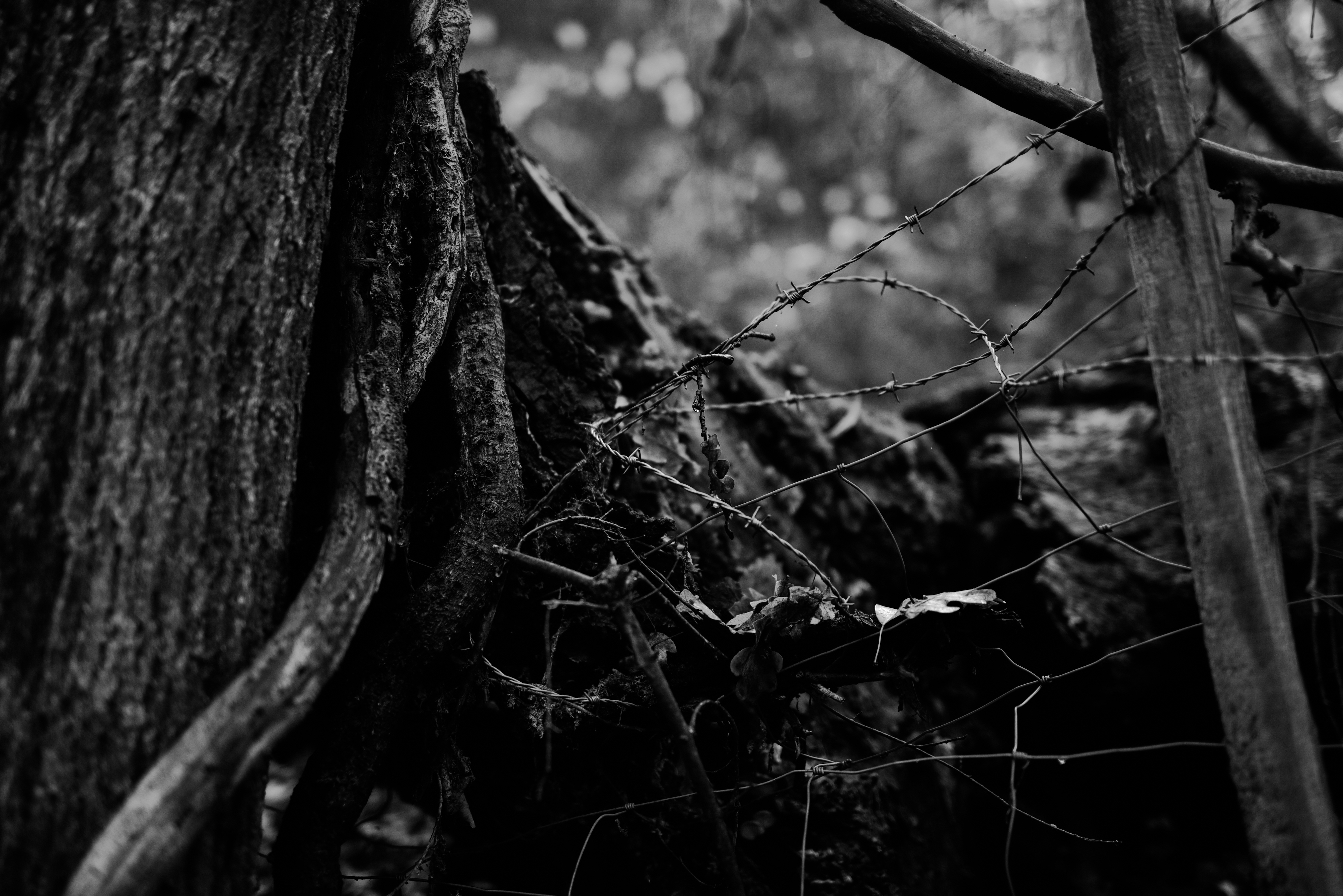 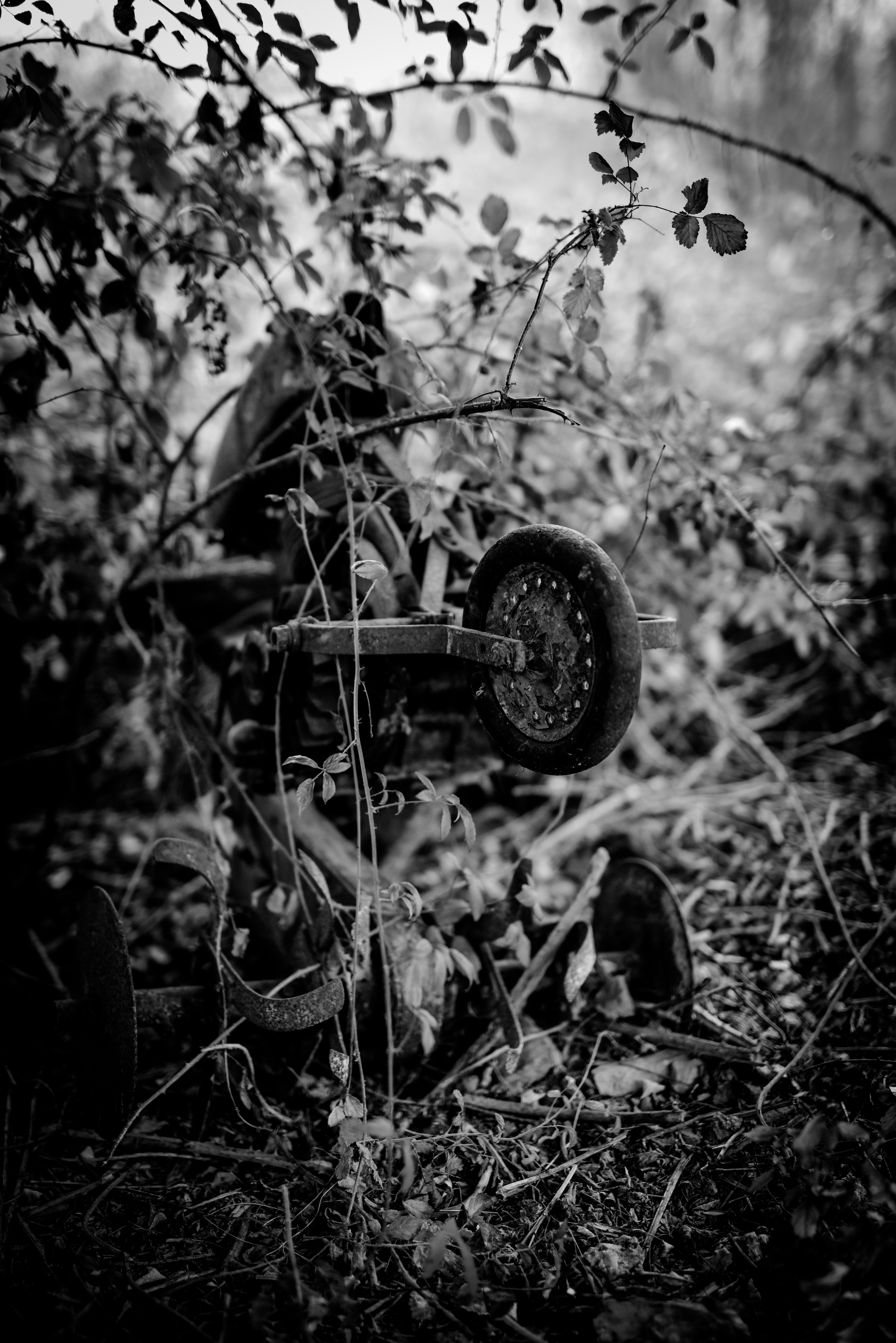 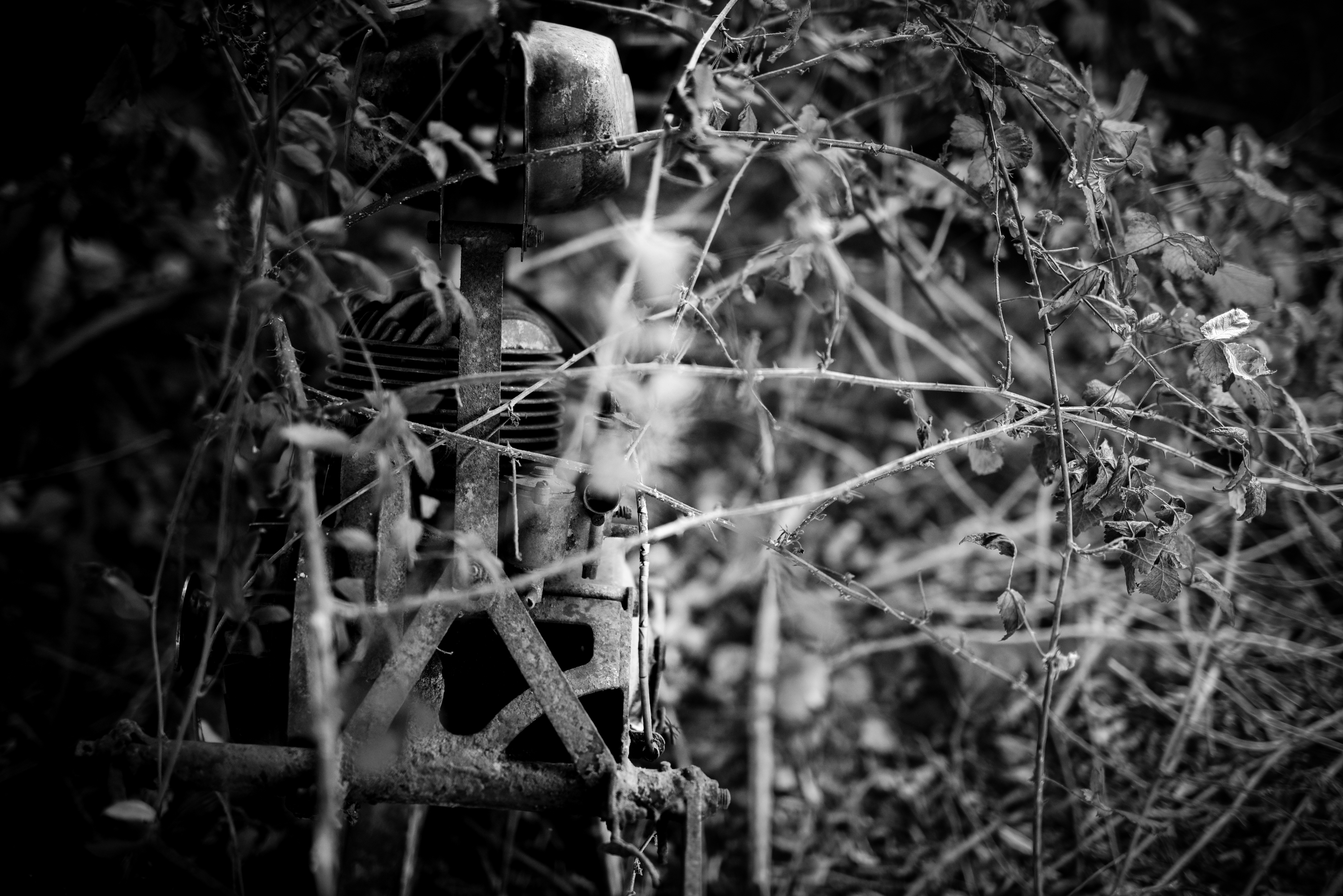 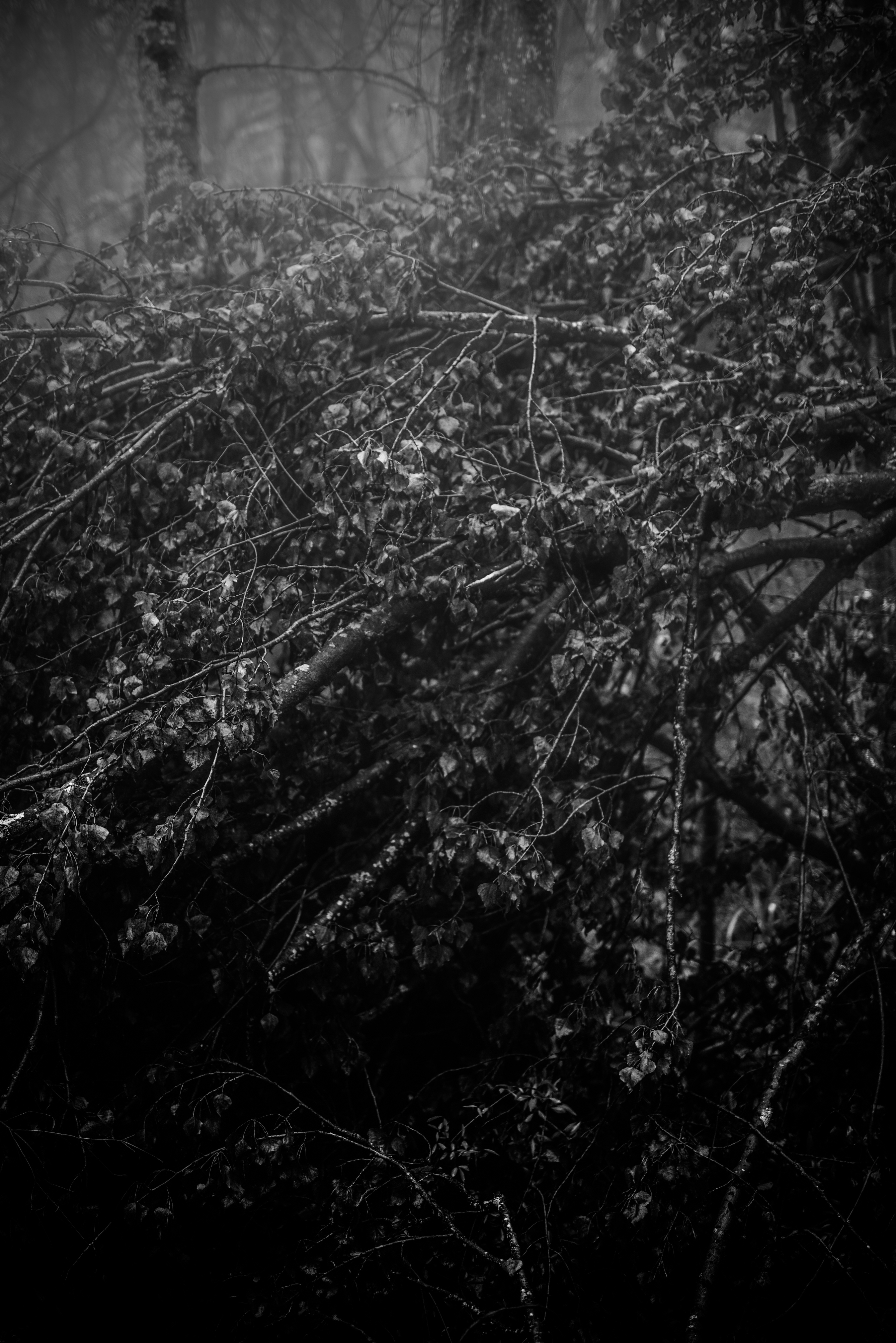 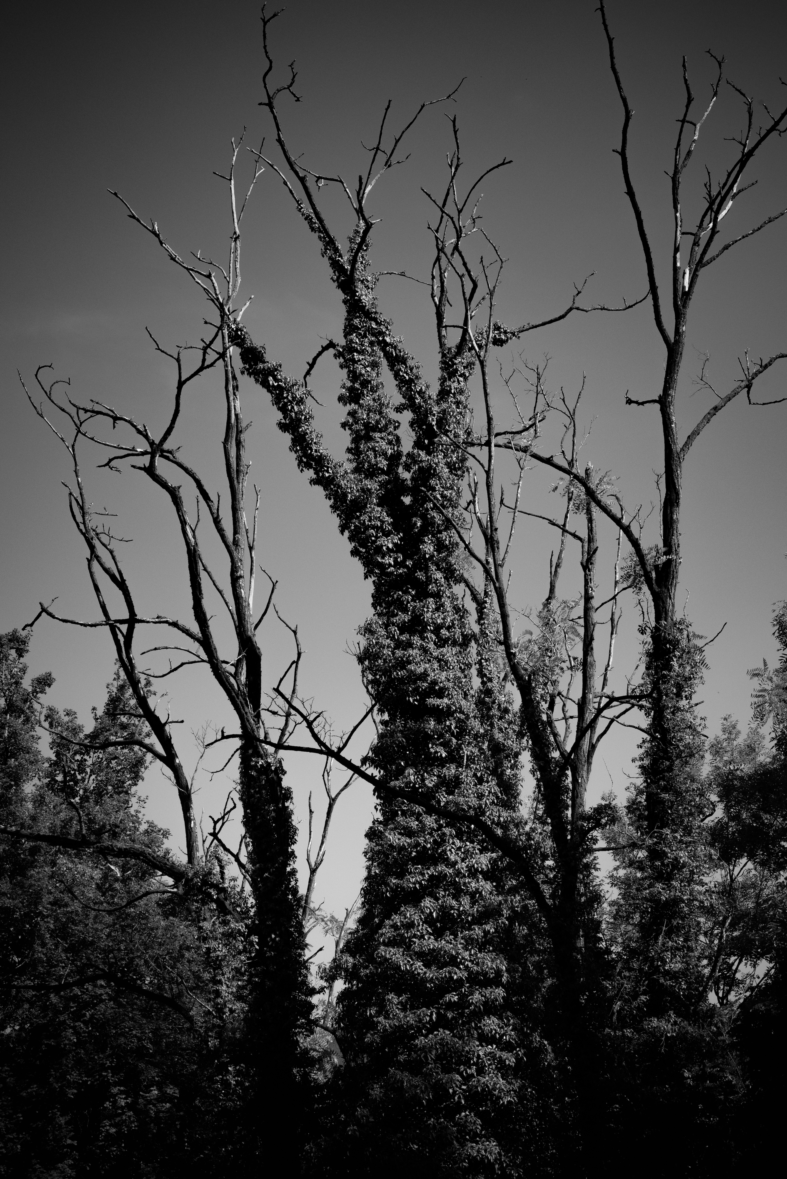 |
| json metadata | {"tags":["photography","nature","forest","blacknwhite","dark"],"image":["https://cdn.steemitimages.com/DQmQayL2jpFuQ1UygsyHF2JR2uMC1M86h1PzdgN527HrokP/S06_0895.jpg","https://cdn.steemitimages.com/DQmbVvE3uTrJKt1sGAeiTqDuaBU1bkCLuYf3DbgcnhkTpdk/S06_2092.jpg","https://cdn.steemitimages.com/DQmXu969Lo5sgWk3BeaLrDkXHQT6J2bo4Tw4eis1K7XxiMR/S06_2117.jpg","https://cdn.steemitimages.com/DQmSJFo1ZcxUTNe191W7kkEoWnyqfkzGC6vD4GG9AZTMdTS/S06_2124.jpg","https://cdn.steemitimages.com/DQmRHPTCjen3EqciTApkU5L8k7d2QyaPGV5ypvgZP9G5Q1S/S06_2139.jpg","https://cdn.steemitimages.com/DQmQiozdhqS7pctciYCcnjFwkjxLQoacCXxCXRmhQPSic1o/S06_2195.jpg","https://cdn.steemitimages.com/DQmXFmSCD92Si5UZtae5bUiefJYpJSBLLDcj4W3GhpzSaYT/S06_2200.jpg","https://cdn.steemitimages.com/DQmd5F1Ai85ketRbgyZwwvhKHFdmz4RXDySBVV4b3S9rYbw/S06_2222.jpg","https://cdn.steemitimages.com/DQmRfTQTUQ1ETJ6324vum3VqFjNnrr2nDC5e6RoUM7RsF3X/S06_2245.jpg","https://cdn.steemitimages.com/DQmQC6CvrAtBALY3cmWRyJvJR5JHE5Jx2S5Pvni6PsWSP6k/S06_2249.jpg","https://cdn.steemitimages.com/DQmSCC4LyYyTn7K6N2X5v1dRbCfdSpkk9KiJPw3sYkyP26o/S06_2252.jpg","https://cdn.steemitimages.com/DQma3ny2KYUbunG3DqDv8aTN2tmL6oU6utqhBU6nage8GrD/S06_2268.jpg","https://cdn.steemitimages.com/DQmPwuVSkDdZM358YaJubWVJGKhbMzLo1vqs6VCfBx7bhMX/S06_2277.jpg","https://cdn.steemitimages.com/DQmSGKmXpBHrngm47jHriCqYLc5EKJkB8w69u9PAhFtW5Dj/S06_2285.jpg","https://cdn.steemitimages.com/DQmV7KmhrKjfAbJKQGCt4eAGA8NSJVJNTcrgENdT3iMjPAP/S06_9533.jpg"],"app":"steemit/0.1","format":"markdown"} |
| Transaction Info | Block #29999681/Trx 0ebddd811466c862dd50310552d7c1a6b02756f4 |
View Raw JSON Data
{
"trx_id": "0ebddd811466c862dd50310552d7c1a6b02756f4",
"block": 29999681,
"trx_in_block": 1,
"op_in_trx": 0,
"virtual_op": 0,
"timestamp": "2019-02-02T16:30:42",
"op": [
"comment",
{
"parent_author": "",
"parent_permlink": "photography",
"author": "aedyn",
"permlink": "chaos-den",
"title": "[Photographs Collection] \"Chaos' Den\" by Adrien Jacquier Bret",
"body": "This collection is about nature's disorder perception. The chaos of interweaved branches and brambles appears to draw a dark and deep den, where light and space are engaged in a fascinating struggle.\n\nThe horror we see in a place that is commonly considered as inhospitable conveys the idea of something offensive and harmful, but yet, full of endless beauties, that carries to our eyes something dangerous but attractive, the only home we've ever known, chaos' den.\n\nAll photographs are mine, taken by myself and protected under the copyright license.\n\n\nCopyright © 2018 Adrien Jacquier Bret\nAll rights reserved.\n\n\n\n\n\n\n\n\n\n\n\n\n\n\n\n\n\n\n\n\n\n\n\n\n\n\n\n\n\n\n",
"json_metadata": "{\"tags\":[\"photography\",\"nature\",\"forest\",\"blacknwhite\",\"dark\"],\"image\":[\"https://cdn.steemitimages.com/DQmQayL2jpFuQ1UygsyHF2JR2uMC1M86h1PzdgN527HrokP/S06_0895.jpg\",\"https://cdn.steemitimages.com/DQmbVvE3uTrJKt1sGAeiTqDuaBU1bkCLuYf3DbgcnhkTpdk/S06_2092.jpg\",\"https://cdn.steemitimages.com/DQmXu969Lo5sgWk3BeaLrDkXHQT6J2bo4Tw4eis1K7XxiMR/S06_2117.jpg\",\"https://cdn.steemitimages.com/DQmSJFo1ZcxUTNe191W7kkEoWnyqfkzGC6vD4GG9AZTMdTS/S06_2124.jpg\",\"https://cdn.steemitimages.com/DQmRHPTCjen3EqciTApkU5L8k7d2QyaPGV5ypvgZP9G5Q1S/S06_2139.jpg\",\"https://cdn.steemitimages.com/DQmQiozdhqS7pctciYCcnjFwkjxLQoacCXxCXRmhQPSic1o/S06_2195.jpg\",\"https://cdn.steemitimages.com/DQmXFmSCD92Si5UZtae5bUiefJYpJSBLLDcj4W3GhpzSaYT/S06_2200.jpg\",\"https://cdn.steemitimages.com/DQmd5F1Ai85ketRbgyZwwvhKHFdmz4RXDySBVV4b3S9rYbw/S06_2222.jpg\",\"https://cdn.steemitimages.com/DQmRfTQTUQ1ETJ6324vum3VqFjNnrr2nDC5e6RoUM7RsF3X/S06_2245.jpg\",\"https://cdn.steemitimages.com/DQmQC6CvrAtBALY3cmWRyJvJR5JHE5Jx2S5Pvni6PsWSP6k/S06_2249.jpg\",\"https://cdn.steemitimages.com/DQmSCC4LyYyTn7K6N2X5v1dRbCfdSpkk9KiJPw3sYkyP26o/S06_2252.jpg\",\"https://cdn.steemitimages.com/DQma3ny2KYUbunG3DqDv8aTN2tmL6oU6utqhBU6nage8GrD/S06_2268.jpg\",\"https://cdn.steemitimages.com/DQmPwuVSkDdZM358YaJubWVJGKhbMzLo1vqs6VCfBx7bhMX/S06_2277.jpg\",\"https://cdn.steemitimages.com/DQmSGKmXpBHrngm47jHriCqYLc5EKJkB8w69u9PAhFtW5Dj/S06_2285.jpg\",\"https://cdn.steemitimages.com/DQmV7KmhrKjfAbJKQGCt4eAGA8NSJVJNTcrgENdT3iMjPAP/S06_9533.jpg\"],\"app\":\"steemit/0.1\",\"format\":\"markdown\"}"
}
]
}2019/02/02 16:28:30
2019/02/02 16:28:30
| parent author | |
| parent permlink | photography |
| author | aedyn |
| permlink | chaos-den |
| title | Chaos' Den |
| body | This collection is about nature's disorder perception. The chaos of interweaved branches and brambles appears to draw a dark and deep den, where light and space are engaged in a fascinating struggle. The horror we see in a place that is commonly considered as inhospitable conveys the idea of something offensive and harmful, but yet, full of endless beauties, that carries to our eyes something dangerous but attractive, the only home we've ever known, chaos' den. All photographs are mine, taken by myself and protected under the copyright license. Copyright © 2018 Adrien Jacquier Bret All rights reserved.                |
| json metadata | {"tags":["photography","nature","forest","blacknwhite","dark"],"image":["https://cdn.steemitimages.com/DQmQayL2jpFuQ1UygsyHF2JR2uMC1M86h1PzdgN527HrokP/S06_0895.jpg","https://cdn.steemitimages.com/DQmbVvE3uTrJKt1sGAeiTqDuaBU1bkCLuYf3DbgcnhkTpdk/S06_2092.jpg","https://cdn.steemitimages.com/DQmXu969Lo5sgWk3BeaLrDkXHQT6J2bo4Tw4eis1K7XxiMR/S06_2117.jpg","https://cdn.steemitimages.com/DQmSJFo1ZcxUTNe191W7kkEoWnyqfkzGC6vD4GG9AZTMdTS/S06_2124.jpg","https://cdn.steemitimages.com/DQmRHPTCjen3EqciTApkU5L8k7d2QyaPGV5ypvgZP9G5Q1S/S06_2139.jpg","https://cdn.steemitimages.com/DQmQiozdhqS7pctciYCcnjFwkjxLQoacCXxCXRmhQPSic1o/S06_2195.jpg","https://cdn.steemitimages.com/DQmXFmSCD92Si5UZtae5bUiefJYpJSBLLDcj4W3GhpzSaYT/S06_2200.jpg","https://cdn.steemitimages.com/DQmd5F1Ai85ketRbgyZwwvhKHFdmz4RXDySBVV4b3S9rYbw/S06_2222.jpg","https://cdn.steemitimages.com/DQmRfTQTUQ1ETJ6324vum3VqFjNnrr2nDC5e6RoUM7RsF3X/S06_2245.jpg","https://cdn.steemitimages.com/DQmQC6CvrAtBALY3cmWRyJvJR5JHE5Jx2S5Pvni6PsWSP6k/S06_2249.jpg","https://cdn.steemitimages.com/DQmSCC4LyYyTn7K6N2X5v1dRbCfdSpkk9KiJPw3sYkyP26o/S06_2252.jpg","https://cdn.steemitimages.com/DQma3ny2KYUbunG3DqDv8aTN2tmL6oU6utqhBU6nage8GrD/S06_2268.jpg","https://cdn.steemitimages.com/DQmPwuVSkDdZM358YaJubWVJGKhbMzLo1vqs6VCfBx7bhMX/S06_2277.jpg","https://cdn.steemitimages.com/DQmSGKmXpBHrngm47jHriCqYLc5EKJkB8w69u9PAhFtW5Dj/S06_2285.jpg","https://cdn.steemitimages.com/DQmV7KmhrKjfAbJKQGCt4eAGA8NSJVJNTcrgENdT3iMjPAP/S06_9533.jpg"],"app":"steemit/0.1","format":"markdown"} |
| Transaction Info | Block #29999637/Trx 6f0de134f7e70160945598e7fc9cb5b7c149ae55 |
View Raw JSON Data
{
"trx_id": "6f0de134f7e70160945598e7fc9cb5b7c149ae55",
"block": 29999637,
"trx_in_block": 13,
"op_in_trx": 0,
"virtual_op": 0,
"timestamp": "2019-02-02T16:28:30",
"op": [
"comment",
{
"parent_author": "",
"parent_permlink": "photography",
"author": "aedyn",
"permlink": "chaos-den",
"title": "Chaos' Den",
"body": "This collection is about nature's disorder perception. The chaos of interweaved branches and brambles appears to draw a dark and deep den, where light and space are engaged in a fascinating struggle.\n\nThe horror we see in a place that is commonly considered as inhospitable conveys the idea of something offensive and harmful, but yet, full of endless beauties, that carries to our eyes something dangerous but attractive, the only home we've ever known, chaos' den.\n\nAll photographs are mine, taken by myself and protected under the copyright license.\n\n\nCopyright © 2018 Adrien Jacquier Bret\nAll rights reserved.\n\n\n\n\n\n\n\n\n\n\n\n\n\n\n\n\n\n\n\n\n\n\n\n\n\n\n\n\n\n\n",
"json_metadata": "{\"tags\":[\"photography\",\"nature\",\"forest\",\"blacknwhite\",\"dark\"],\"image\":[\"https://cdn.steemitimages.com/DQmQayL2jpFuQ1UygsyHF2JR2uMC1M86h1PzdgN527HrokP/S06_0895.jpg\",\"https://cdn.steemitimages.com/DQmbVvE3uTrJKt1sGAeiTqDuaBU1bkCLuYf3DbgcnhkTpdk/S06_2092.jpg\",\"https://cdn.steemitimages.com/DQmXu969Lo5sgWk3BeaLrDkXHQT6J2bo4Tw4eis1K7XxiMR/S06_2117.jpg\",\"https://cdn.steemitimages.com/DQmSJFo1ZcxUTNe191W7kkEoWnyqfkzGC6vD4GG9AZTMdTS/S06_2124.jpg\",\"https://cdn.steemitimages.com/DQmRHPTCjen3EqciTApkU5L8k7d2QyaPGV5ypvgZP9G5Q1S/S06_2139.jpg\",\"https://cdn.steemitimages.com/DQmQiozdhqS7pctciYCcnjFwkjxLQoacCXxCXRmhQPSic1o/S06_2195.jpg\",\"https://cdn.steemitimages.com/DQmXFmSCD92Si5UZtae5bUiefJYpJSBLLDcj4W3GhpzSaYT/S06_2200.jpg\",\"https://cdn.steemitimages.com/DQmd5F1Ai85ketRbgyZwwvhKHFdmz4RXDySBVV4b3S9rYbw/S06_2222.jpg\",\"https://cdn.steemitimages.com/DQmRfTQTUQ1ETJ6324vum3VqFjNnrr2nDC5e6RoUM7RsF3X/S06_2245.jpg\",\"https://cdn.steemitimages.com/DQmQC6CvrAtBALY3cmWRyJvJR5JHE5Jx2S5Pvni6PsWSP6k/S06_2249.jpg\",\"https://cdn.steemitimages.com/DQmSCC4LyYyTn7K6N2X5v1dRbCfdSpkk9KiJPw3sYkyP26o/S06_2252.jpg\",\"https://cdn.steemitimages.com/DQma3ny2KYUbunG3DqDv8aTN2tmL6oU6utqhBU6nage8GrD/S06_2268.jpg\",\"https://cdn.steemitimages.com/DQmPwuVSkDdZM358YaJubWVJGKhbMzLo1vqs6VCfBx7bhMX/S06_2277.jpg\",\"https://cdn.steemitimages.com/DQmSGKmXpBHrngm47jHriCqYLc5EKJkB8w69u9PAhFtW5Dj/S06_2285.jpg\",\"https://cdn.steemitimages.com/DQmV7KmhrKjfAbJKQGCt4eAGA8NSJVJNTcrgENdT3iMjPAP/S06_9533.jpg\"],\"app\":\"steemit/0.1\",\"format\":\"markdown\"}"
}
]
}2018/11/26 16:27:09
2018/11/26 16:27:09
| delegator | steem |
| delegatee | aedyn |
| vesting shares | 9867.394816 VESTS |
| Transaction Info | Block #28042684/Trx d07cb38d17c5e47519d7c2c87556286f46526ae0 |
View Raw JSON Data
{
  "trx_id": "d07cb38d17c5e47519d7c2c87556286f46526ae0",
  "block": 28042684,
  "trx_in_block": 10,
  "op_in_trx": 0,
  "virtual_op": 0,
  "timestamp": "2018-11-26T16:27:09",
  "op": [
    "delegate_vesting_shares",
    {
      "delegator": "steem",
      "delegatee": "aedyn",
      "vesting_shares": "9867.394816 VESTS"
    }
  ]
}2018/08/18 18:15:33
2018/08/18 18:15:33
| parent author | aedyn |
| parent permlink | en-fr-domes-de-miage-mont-blanc-mountains-2-days-trip |
| author | aerithe77 |
| permlink | re-aedyn-en-fr-domes-de-miage-mont-blanc-mountains-2-days-trip-20180818t181531079z |
| title | |
| body | Super article ! Mais vu la longueur peut-être serait-il intéressant de séparer en deux articles : un Fr et un En ? |
| json metadata | {"community":"busy","app":"busy/2.5.6","format":"markdown","tags":["mountaineering"],"users":[],"links":[],"image":[]} |
| Transaction Info | Block #25182387/Trx 71bfc888b15fa3cfd2ee68d25073d41782ae6dfc |
View Raw JSON Data
{
  "trx_id": "71bfc888b15fa3cfd2ee68d25073d41782ae6dfc",
  "block": 25182387,
  "trx_in_block": 25,
  "op_in_trx": 0,
  "virtual_op": 0,
  "timestamp": "2018-08-18T18:15:33",
  "op": [
    "comment",
    {
      "parent_author": "aedyn",
      "parent_permlink": "en-fr-domes-de-miage-mont-blanc-mountains-2-days-trip",
      "author": "aerithe77",
      "permlink": "re-aedyn-en-fr-domes-de-miage-mont-blanc-mountains-2-days-trip-20180818t181531079z",
      "title": "",
      "body": "Super article ! Mais vu la longueur peut-être serait-il intéressant de séparer en deux articles : un Fr et un En ?",
      "json_metadata": "{\"community\":\"busy\",\"app\":\"busy/2.5.6\",\"format\":\"markdown\",\"tags\":[\"mountaineering\"],\"users\":[],\"links\":[],\"image\":[]}"
    }
  ]
}2018/08/18 09:38:15
2018/08/18 09:38:15
| voter | fatin-a-rts |
| author | aedyn |
| permlink | re-fatin-a-rts-re-aedyn-en-fr-domes-de-miage-mont-blanc-mountains-2-days-trip-20180817t205105572z |
| weight | 10000 (100.00%) |
| Transaction Info | Block #25172045/Trx 59e1c19bce75904755aa84d087bbcbd51d9aca52 |
View Raw JSON Data
{
  "trx_id": "59e1c19bce75904755aa84d087bbcbd51d9aca52",
  "block": 25172045,
  "trx_in_block": 18,
  "op_in_trx": 0,
  "virtual_op": 0,
  "timestamp": "2018-08-18T09:38:15",
  "op": [
    "vote",
    {
      "voter": "fatin-a-rts",
      "author": "aedyn",
      "permlink": "re-fatin-a-rts-re-aedyn-en-fr-domes-de-miage-mont-blanc-mountains-2-days-trip-20180817t205105572z",
      "weight": 10000
    }
  ]
}aedynupvoted (100.00%) @luigiborla / mont-blanc-chere-gully-monte-bianco-goulotte-chere2018/08/17 22:22:54
aedynupvoted (100.00%) @luigiborla / mont-blanc-chere-gully-monte-bianco-goulotte-chere
2018/08/17 22:22:54
| voter | aedyn |
| author | luigiborla |
| permlink | mont-blanc-chere-gully-monte-bianco-goulotte-chere |
| weight | 10000 (100.00%) |
| Transaction Info | Block #25158548/Trx 8ba2defbe52bb1c809bbb0b957f9fc4edb7d32ab |
View Raw JSON Data
{
  "trx_id": "8ba2defbe52bb1c809bbb0b957f9fc4edb7d32ab",
  "block": 25158548,
  "trx_in_block": 8,
  "op_in_trx": 0,
  "virtual_op": 0,
  "timestamp": "2018-08-17T22:22:54",
  "op": [
    "vote",
    {
      "voter": "aedyn",
      "author": "luigiborla",
      "permlink": "mont-blanc-chere-gully-monte-bianco-goulotte-chere",
      "weight": 10000
    }
  ]
}aedynfollowed @fatin-a-rts2018/08/17 21:22:33
aedynfollowed @fatin-a-rts
2018/08/17 21:22:33
| required auths | [] |
| required posting auths | ["aedyn"] |
| id | follow |
| json | ["follow",{"follower":"aedyn","following":"fatin-a-rts","what":["blog"]}] |
| Transaction Info | Block #25157341/Trx 27e5976c5b486695fb67cf8fd88e9882fe265ff0 |
View Raw JSON Data
{
  "trx_id": "27e5976c5b486695fb67cf8fd88e9882fe265ff0",
  "block": 25157341,
  "trx_in_block": 36,
  "op_in_trx": 0,
  "virtual_op": 0,
  "timestamp": "2018-08-17T21:22:33",
  "op": [
    "custom_json",
    {
      "required_auths": [],
      "required_posting_auths": [
        "aedyn"
      ],
      "id": "follow",
      "json": "[\"follow\",{\"follower\":\"aedyn\",\"following\":\"fatin-a-rts\",\"what\":[\"blog\"]}]"
    }
  ]
}2018/08/17 20:51:06
2018/08/17 20:51:06
| parent author | fatin-a-rts |
| parent permlink | re-aedyn-en-fr-domes-de-miage-mont-blanc-mountains-2-days-trip-20180817t175440409z |
| author | aedyn |
| permlink | re-fatin-a-rts-re-aedyn-en-fr-domes-de-miage-mont-blanc-mountains-2-days-trip-20180817t205105572z |
| title | |
| body | Merci beaucoup ! La musique de la vidéo s'appelle "Different Pulses - Asaf Avidan" |
| json metadata | {"tags":["mountaineering"],"app":"steemit/0.1"} |
| Transaction Info | Block #25156712/Trx 3e6b5584f5f350dd41ba8803f9eb06b5c05c972e |
View Raw JSON Data
{
  "trx_id": "3e6b5584f5f350dd41ba8803f9eb06b5c05c972e",
  "block": 25156712,
  "trx_in_block": 17,
  "op_in_trx": 0,
  "virtual_op": 0,
  "timestamp": "2018-08-17T20:51:06",
  "op": [
    "comment",
    {
      "parent_author": "fatin-a-rts",
      "parent_permlink": "re-aedyn-en-fr-domes-de-miage-mont-blanc-mountains-2-days-trip-20180817t175440409z",
      "author": "aedyn",
      "permlink": "re-fatin-a-rts-re-aedyn-en-fr-domes-de-miage-mont-blanc-mountains-2-days-trip-20180817t205105572z",
      "title": "",
      "body": "Merci beaucoup ! La musique de la vidéo s'appelle \"Different Pulses - Asaf Avidan\"",
      "json_metadata": "{\"tags\":[\"mountaineering\"],\"app\":\"steemit/0.1\"}"
    }
  ]
}moby-dickupvoted (100.00%) @aedyn / en-fr-domes-de-miage-mont-blanc-mountains-2-days-trip2018/08/17 18:54:03
moby-dickupvoted (100.00%) @aedyn / en-fr-domes-de-miage-mont-blanc-mountains-2-days-trip
2018/08/17 18:54:03
| voter | moby-dick |
| author | aedyn |
| permlink | en-fr-domes-de-miage-mont-blanc-mountains-2-days-trip |
| weight | 10000 (100.00%) |
| Transaction Info | Block #25154371/Trx 981b23c85e68d708bc9ac560f2576086964ae31e |
View Raw JSON Data
{
  "trx_id": "981b23c85e68d708bc9ac560f2576086964ae31e",
  "block": 25154371,
  "trx_in_block": 14,
  "op_in_trx": 0,
  "virtual_op": 0,
  "timestamp": "2018-08-17T18:54:03",
  "op": [
    "vote",
    {
      "voter": "moby-dick",
      "author": "aedyn",
      "permlink": "en-fr-domes-de-miage-mont-blanc-mountains-2-days-trip",
      "weight": 10000
    }
  ]
}2018/08/17 17:54:45
2018/08/17 17:54:45
| parent author | aedyn |
| parent permlink | en-fr-domes-de-miage-mont-blanc-mountains-2-days-trip |
| author | fatin-a-rts |
| permlink | re-aedyn-en-fr-domes-de-miage-mont-blanc-mountains-2-days-trip-20180817t175440409z |
| title | |
| body | (乂ღ˘⌣˘)ノ♥ UN GRAND MERCI C'est magnifique ! La vidéo est vraiment réussie, pouvez-vous me donner le titre de la musique de fond. |
| json metadata | {"tags":["mountaineering"],"app":"steemit/0.1"} |
| Transaction Info | Block #25153186/Trx af0090208cc59bf88f8df600f6718a1ba716b93b |
View Raw JSON Data
{
  "trx_id": "af0090208cc59bf88f8df600f6718a1ba716b93b",
  "block": 25153186,
  "trx_in_block": 14,
  "op_in_trx": 0,
  "virtual_op": 0,
  "timestamp": "2018-08-17T17:54:45",
  "op": [
    "comment",
    {
      "parent_author": "aedyn",
      "parent_permlink": "en-fr-domes-de-miage-mont-blanc-mountains-2-days-trip",
      "author": "fatin-a-rts",
      "permlink": "re-aedyn-en-fr-domes-de-miage-mont-blanc-mountains-2-days-trip-20180817t175440409z",
      "title": "",
      "body": "(乂ღ˘⌣˘)ノ♥ UN GRAND MERCI  C'est magnifique !\nLa vidéo est vraiment réussie, pouvez-vous me donner le titre de la musique de fond.",
      "json_metadata": "{\"tags\":[\"mountaineering\"],\"app\":\"steemit/0.1\"}"
    }
  ]
}fatin-a-rtsupvoted (100.00%) @aedyn / en-fr-domes-de-miage-mont-blanc-mountains-2-days-trip2018/08/17 17:46:06
fatin-a-rtsupvoted (100.00%) @aedyn / en-fr-domes-de-miage-mont-blanc-mountains-2-days-trip
2018/08/17 17:46:06
| voter | fatin-a-rts |
| author | aedyn |
| permlink | en-fr-domes-de-miage-mont-blanc-mountains-2-days-trip |
| weight | 10000 (100.00%) |
| Transaction Info | Block #25153013/Trx 822814b78bd1cb0788d7b0f603e500c987e0f52f |
View Raw JSON Data
{
  "trx_id": "822814b78bd1cb0788d7b0f603e500c987e0f52f",
  "block": 25153013,
  "trx_in_block": 33,
  "op_in_trx": 0,
  "virtual_op": 0,
  "timestamp": "2018-08-17T17:46:06",
  "op": [
    "vote",
    {
      "voter": "fatin-a-rts",
      "author": "aedyn",
      "permlink": "en-fr-domes-de-miage-mont-blanc-mountains-2-days-trip",
      "weight": 10000
    }
  ]
}aedynpublished a new post: en-fr-domes-de-miage-mont-blanc-mountains-2-days-trip2018/08/17 15:39:39
aedynpublished a new post: en-fr-domes-de-miage-mont-blanc-mountains-2-days-trip
2018/08/17 15:39:39
| parent author | |
| parent permlink | mountaineering |
| author | aedyn |
| permlink | en-fr-domes-de-miage-mont-blanc-mountains-2-days-trip |
| title | [EN/FR] Dômes De Miage (Mont Blanc Mountains) - 2 Days Trip |
| body | # Dômes De Miage (Mont Blanc Mountains) - 2 Days Trip ###### <b>TRADUCTION FRANÇAISE EN BAS DE PAGE (FRENCH TRANSLATION AT THE BOTTOM) </b> 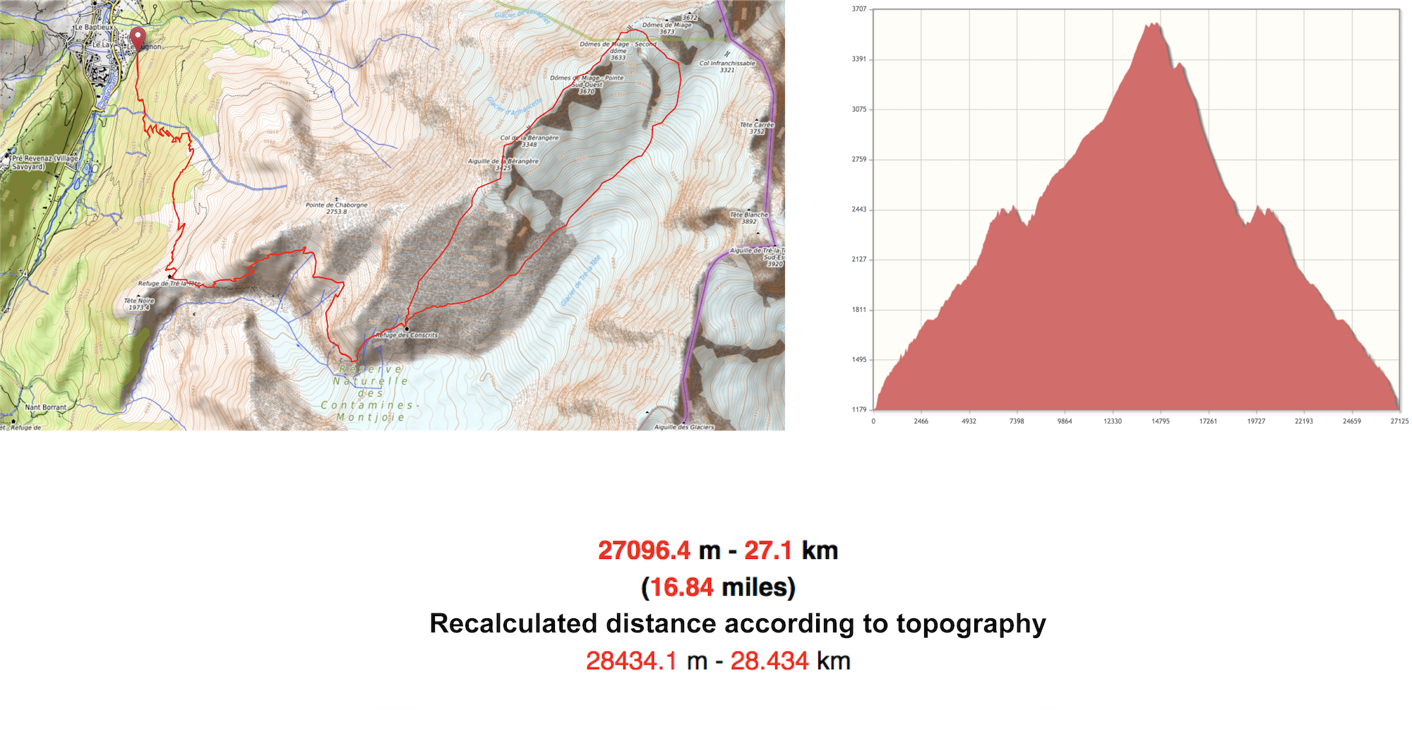 <strong><h2><b>Details</h2></strong> https://www.visorando.com/img/fiches/duree.png Duration : 20h https://www.visorando.com/img/fiches/distance.png Distance : 28.5km https://www.visorando.com/img/fiches/denivele-plus.png Ascending elevation : 3624m (11 889 ft.) https://www.visorando.com/img/fiches/denivele-moins.png Descending elevation : 3617m (11 866 ft.) https://www.visorando.com/img/fiches/point-haut.png Highest point : 3670m (12 040 ft.) https://www.visorando.com/img/fiches/point-bas.png Lowest point : 1180m (3871 ft.) https://www.visorando.com/img/fiches/difficulte-tres-difficile.png Mountaineering cotation : PD II (not much difficult) The goal of the week is to climb the Dômes De Miage summit at 3673m (12 050 ft.), located in the Mont Blanc Mountains, it is a famous mountaineering race especially because of the beauty of the final snow ridge, and because of almost no technical skills required when the weather isn't bad or many routes aren't frozen or slippery. Despite the "PD-" (not much difficult) rating of the race, some places are still dangerous without being with someone a little bit skillful about mountaineering. Our team is composed of my brother and I, Thibaud and Adrien Jacquier Bret, and our teammate Clément Fivel, who already climbed some mountains and is a lot more experienced than we are, he will be our guide and leading climber. https://youtu.be/nCQsvERaQ-0 <blockquote> <p>The final film of our trip</p> <p><h6>Copyright © Clément Fivel</h6></p> </blockquote> Starting from Les Contamines-Montjoie, we begin to hike until arriving at the first mid-mountain refuge, the Refuge De Tré-La-Tête (1970m/6463 ft.), next to which we ate our lunches and had some rest before heading to the second refuge. The itinerary we must follow to achieve this hike is pretty hard in the beginning, steep, rocky, and helped by fixed ropes, but then becomes flat and snaking, for a long time, until arriving at the 60m long (196 ft.) Passerelle Himalayenne (footbridge) crossing a huge gulf, before showing the last part of the hike, leading to the second refuge. 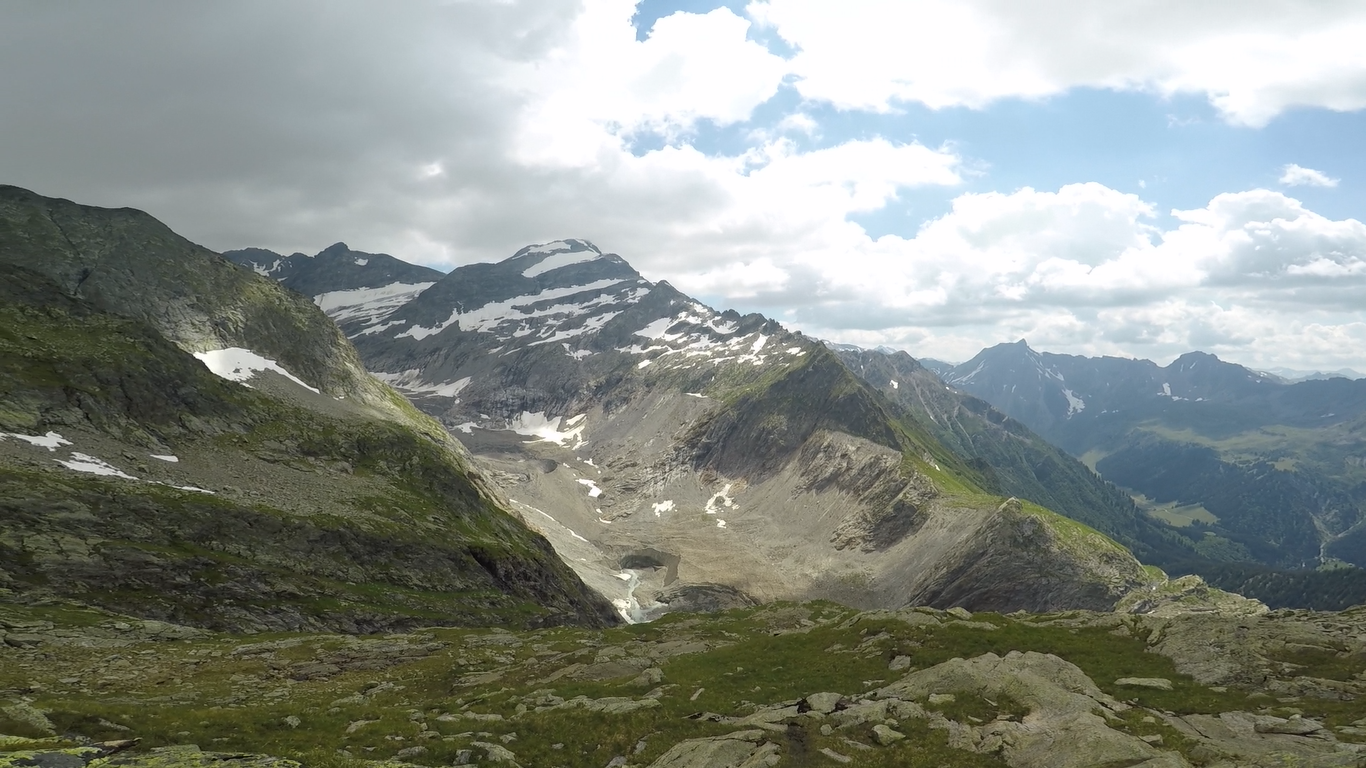 <blockquote> <p>During the hike between the two refuges</p> <p><h6>Copyright © Clément Fivel</h6></p> </blockquote> https://youtu.be/IyJk7-eeBhg <blockquote> <p>The Passerelle Himalayenne</p> <p><h6>Copyright © Clément Fivel</h6></p> </blockquote> Then, after a last but hard walk because being exhausted, we arrived at the second refuge at about 2610m (8562 ft.) of altitude, the Refuge Des Conscrits, a large building built in 1997 (the old one is now destroyed) on the right edge of the huge Glacier De Tré-La-Tête next to which we hiked all day long. The refuge is actually the most important one of the Tré-La-Tête area in this mountains, and also the most attended, from which many mountaineering races are starting, including the famous Voie Royale (Royal Path), crossing the Dômes De Miage and the Aiguille De Bionnassay to finally finish at the top of the Mont Blanc. Approaching the first rocks indicating the end of the day, we are first stricken by the escarpment of the structure, and the isolation of such a living place, but then, delighted by the perspective of a sit and a warm place. After having dropped all our stuff, payed our booking and being given slippers, the good weather lets us smoking a cigarette and drinking a fresh beer on the terrace before a meal and a short but comfortable night. 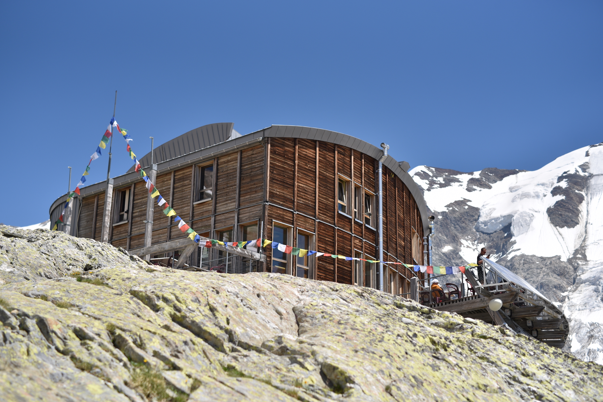 <blockquote> <p>Refuge Des Conscrits (2610m)</p> <p><h6>Copyright © Adrien Jacquier Bret</h6></p> </blockquote> It's now 3:00 a.m and we get up from our warm and cosy beds, get down to have a brief breakfast (in fact, a part of our rations for the lunch and meal) and to wear our mountaineering clothes and gear. At 4:30 a.m, helmets and headlamps put on, we're finally ready to start climbing and are beginning to walk on slippery rocks, before we put on our crampons when arriving on the glacier. The Glacier De Tré-La-Tête, seven kilometers long, is the third biggest glacier in France and in the Mont Blanc Mountains, and is the one that has been the less studied by scientists because of its isolation and difficult access, it is, like every glacier in these mountains, full of crevasses, and shrinking every year because of global warming, making it more dangerous and uncertain for climbers. At 6:00 a.m the team is now walking on hard snow, with a bit of difficulty due to the shape of it, solid snow waves graven by the wind, forcing us to make every step on the top of every ridge, and tiring a bit our legs. But we are also walking in a pure and beautiful valley of ice, looking at the shy and thin light of sunrise, while glowing sunbeams are slowly cuddling the summit of mountains, nothing could be more pleasant than this feeling, than this silence. 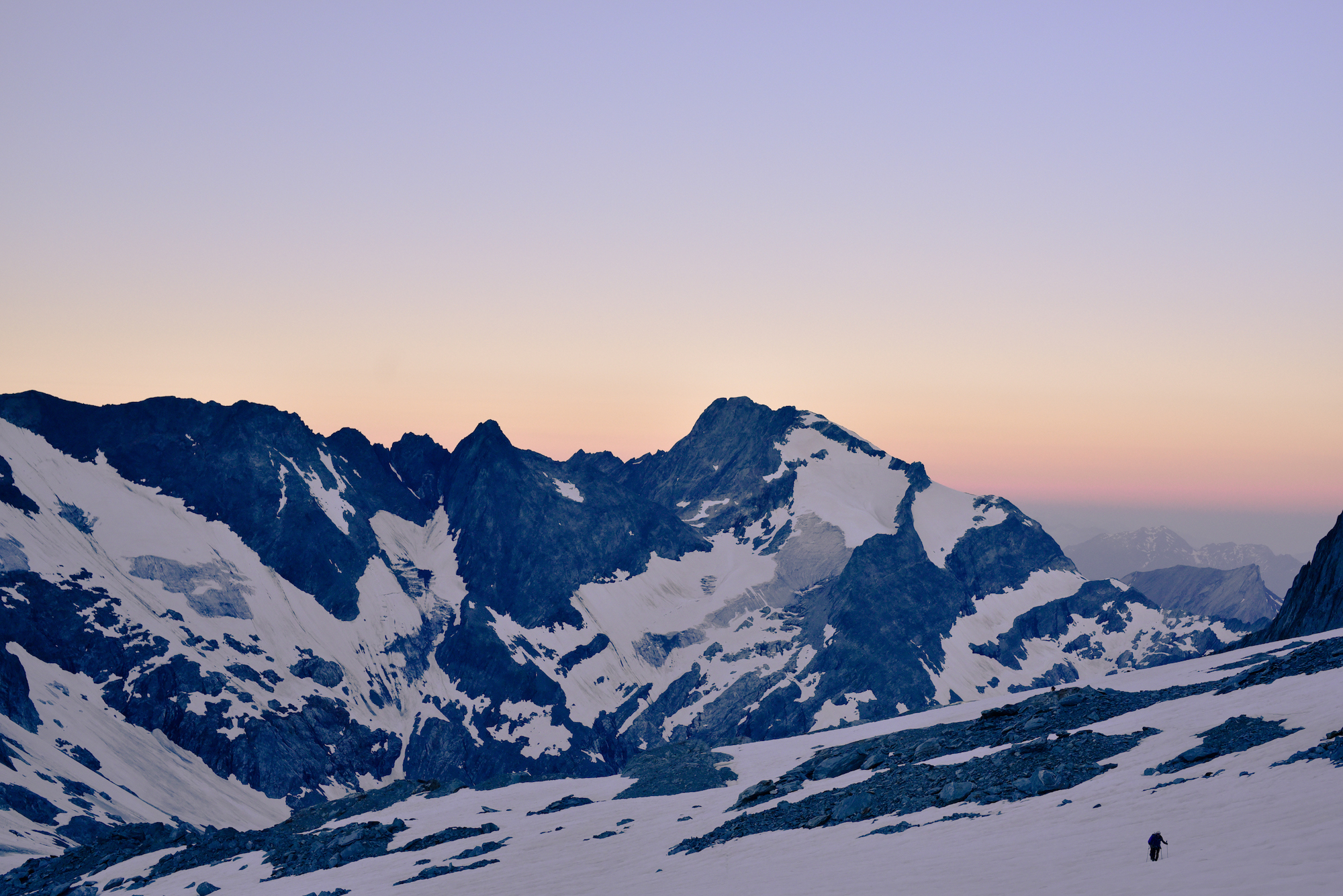 <blockquote> <p>First lights coming from the East of the glacier</p> <p><h6>Copyright © Adrien Jacquier Bret</h6></p> </blockquote> It's time for us to be more careful about our movements, especially because we had to pass a bunch of crevasses and to check the reliability of snow bridges. But it's also time to suffer a bit more while climbing the Col Infranchissable (Impassable Mountain Pass) (3350m/10 990 ft.) and to get colder at the top of it, because of the temperature (-6/-9°C // 15/21°F) and also because of the wind chill effect. But we are finally reaching the sunbeams and are beginning to warm up during the ascent of the Col Des Dômes (3564m/11 692 ft.) that is endless and tiresome, but that is offering us a beautiful view of the whole Passy Valley, the Aravis Mountains and at the bottom of the mountain, Les Contamines-Montjoie. https://youtu.be/xAIrr55wwjo <blockquote> <p>A big crevasse during the ascent</p> <p><h6>Copyright © Clément Fivel</h6></p> </blockquote> 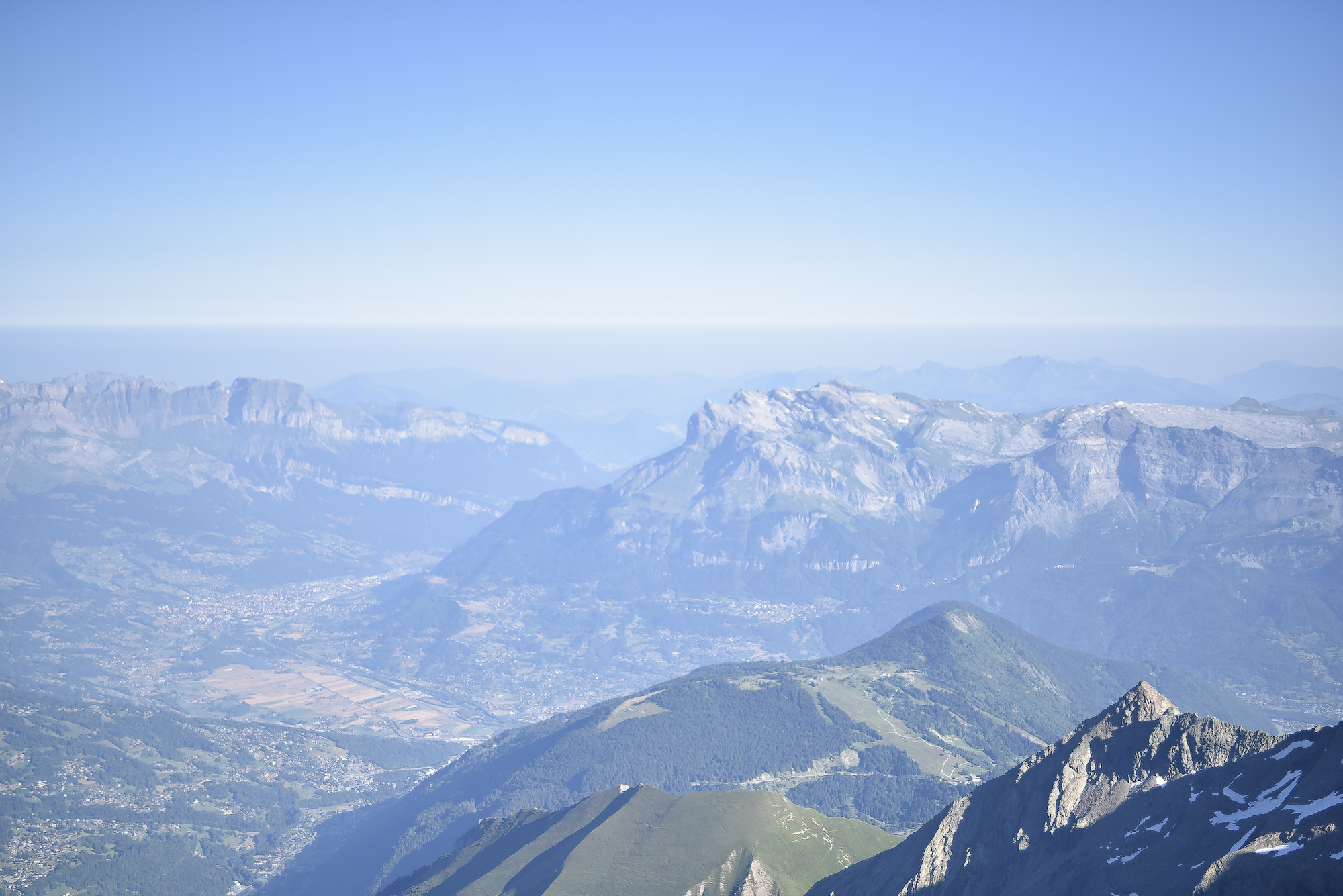 <blockquote> <p>A view of the valley</p> <p><h6>Copyright © Adrien Jacquier Bret</h6></p> </blockquote> 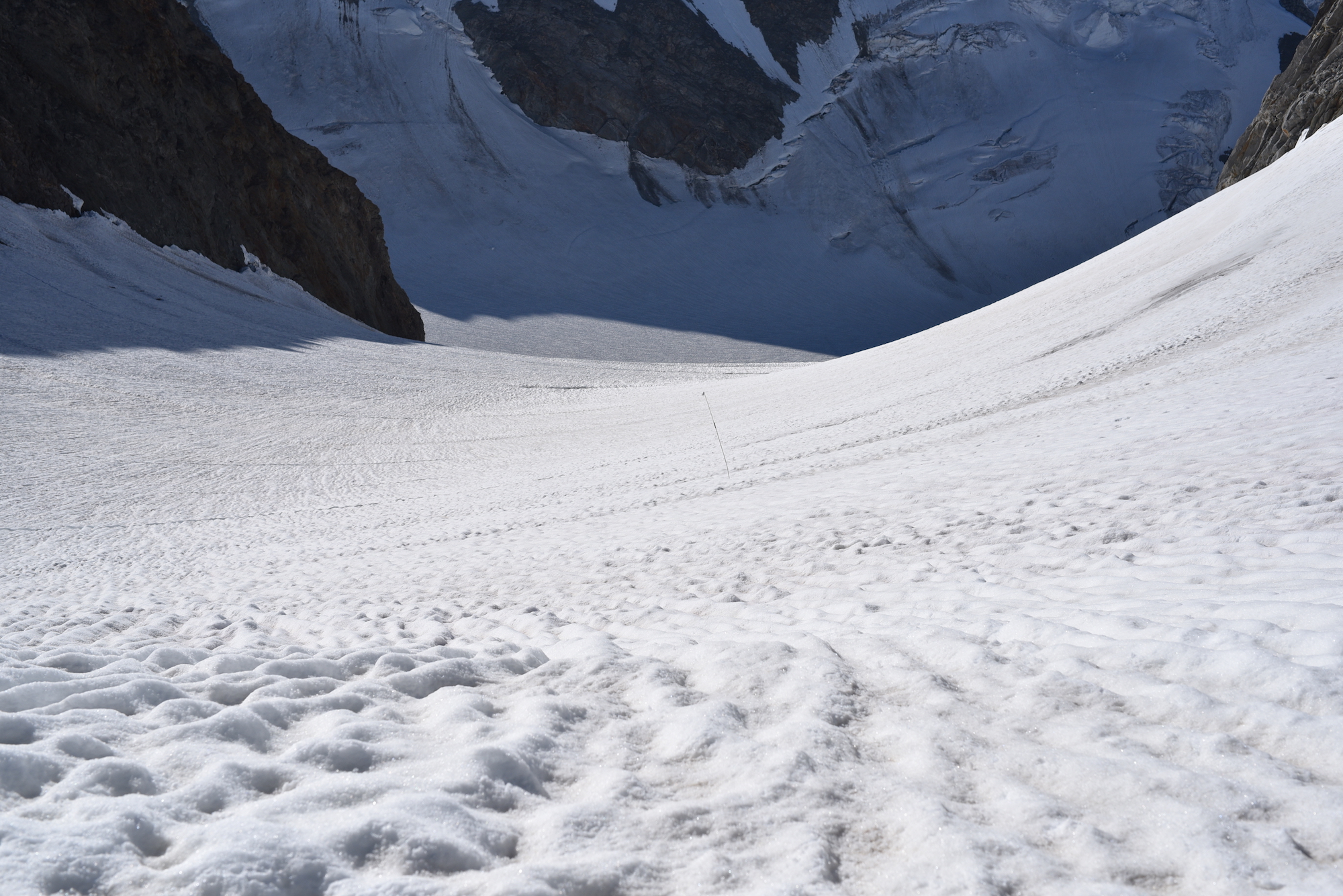 <blockquote> <p>The steep slope leading to the Col Des Dômes</p> <p><h6>Copyright © Adrien Jacquier Bret</h6></p> </blockquote> 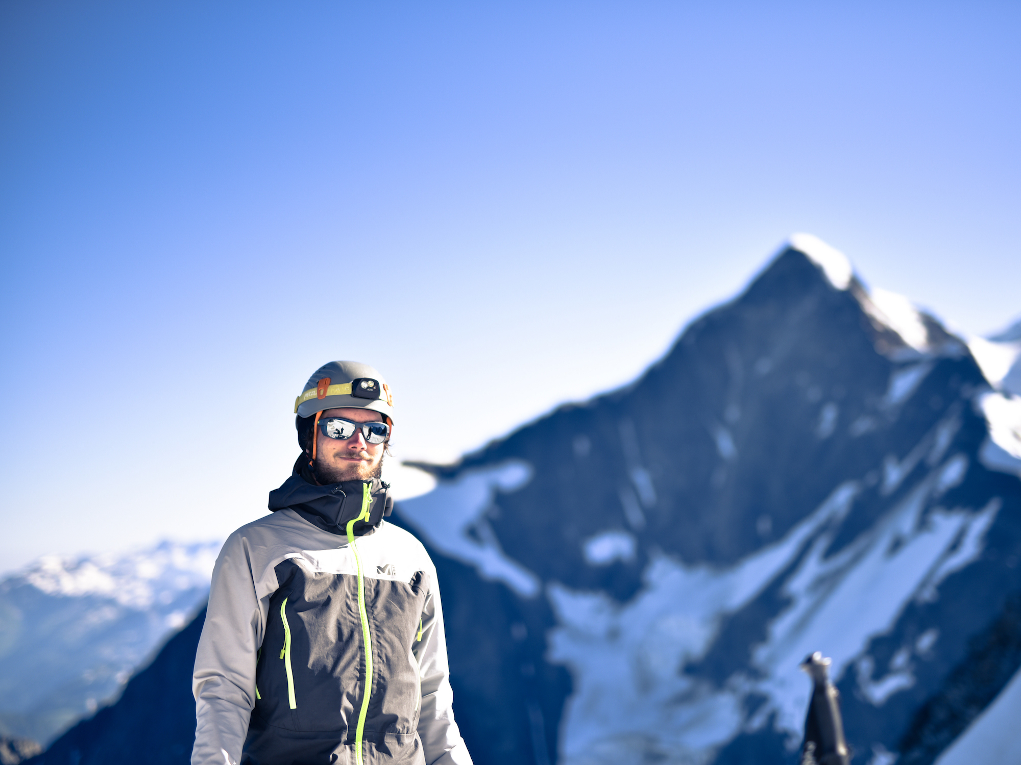 <blockquote> <p>Adrien</p> <p><h6>Copyright © Adrien Jacquier Bret</h6></p> </blockquote> 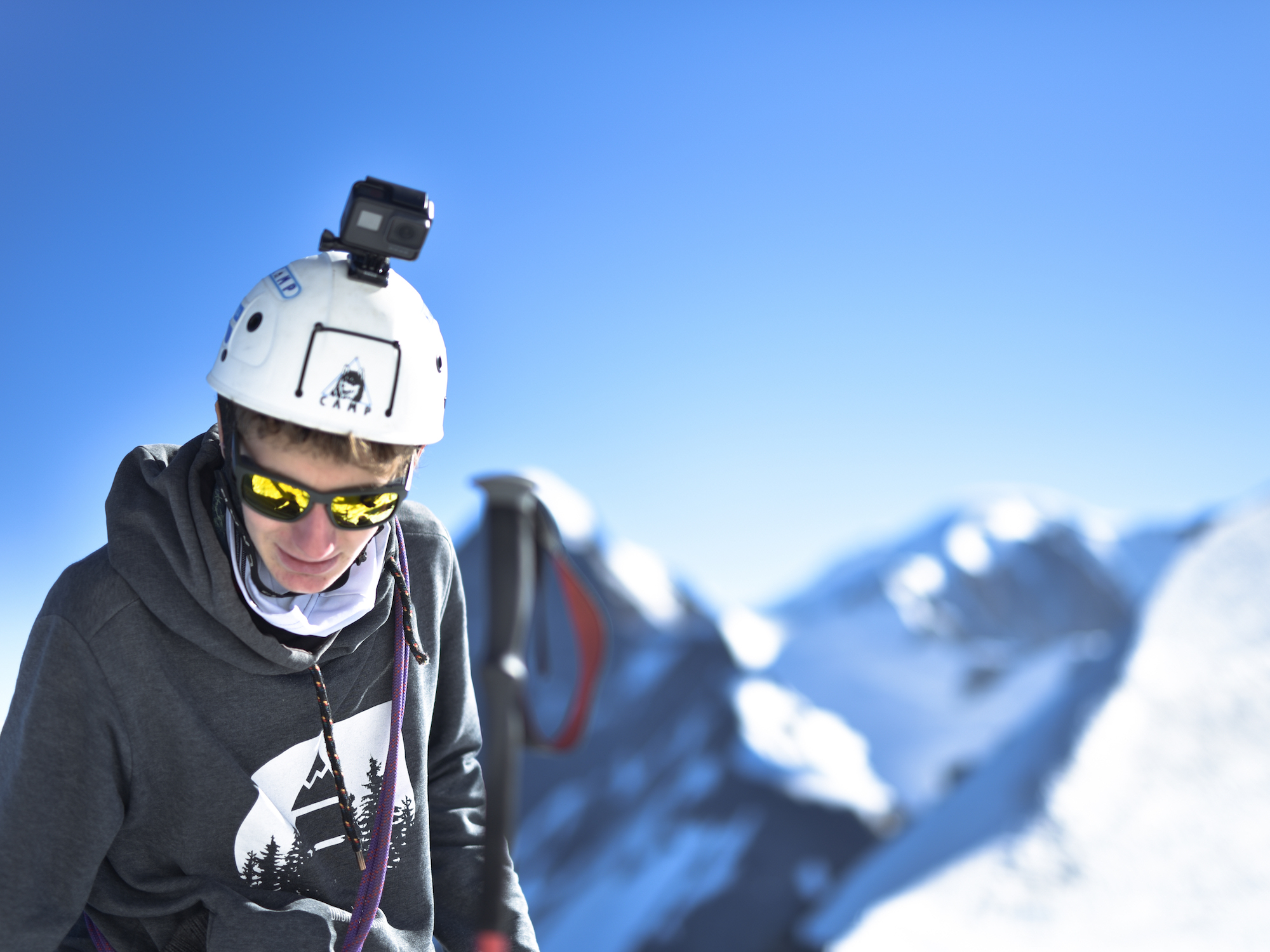 <blockquote> <p>Clément, our teammate</p> <p><h6>Copyright © Adrien Jacquier Bret</h6></p> </blockquote> 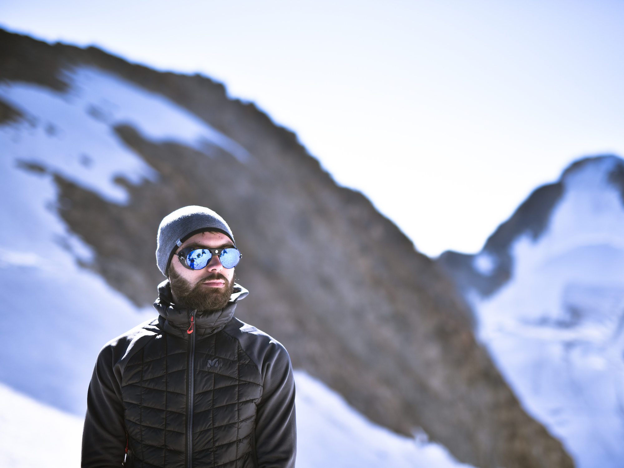 <blockquote> <p>Thibaud</p> <p><h6>Copyright © Adrien Jacquier Bret</h6></p> </blockquote> After a short break during which we ate a bit of fruit bars and took some pictures, we are now climbing a steep slope of ice (about 45° at some points), a dangerous but unavoidable way to reach the summit. When we arrive, a beautiful panorama is waiting for us, the Mont Blanc is shinning under the morning sun, standing in front of the world, proudly, the Aiguille De Bionnassay is offering us its South-West face whose steepness can't let the snow covering it, showing the way of the Voie Royale. We are also amazed by the gigantic seracs of the Aiguille De Tré-La-Tête, nearly falling off the mountain and drawing deep and black lesions in the snow, but the beauty of our trip is mainly about the snow ridge that shows the way to the next and final summit (we count five different summits at the top of the mountain). 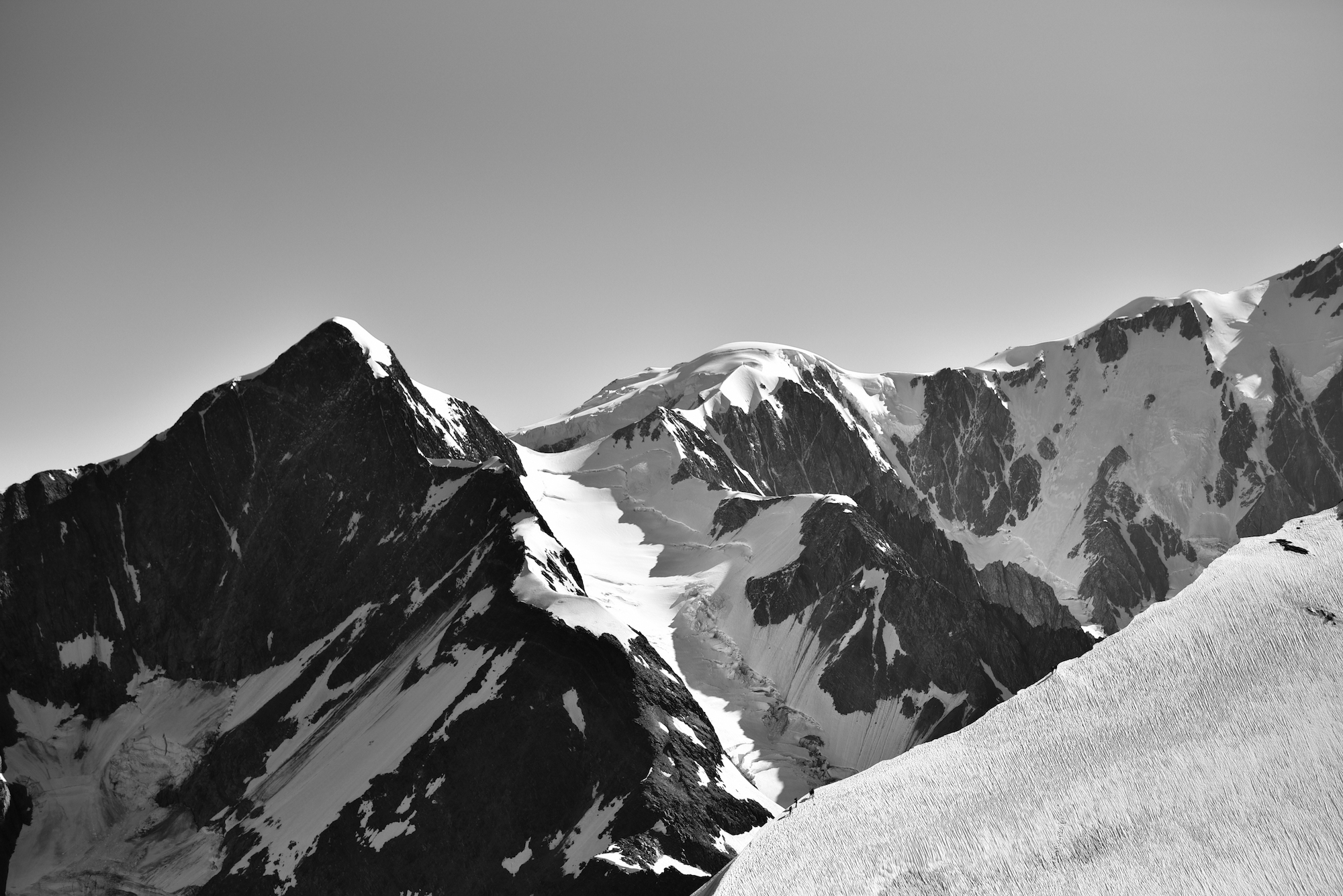 <blockquote> <p>A view of the Aiguille De Bionnassay and the Dôme Du Goûter next to the Mont Blanc</p> <p><h6>Copyright © Adrien Jacquier Bret</h6></p> </blockquote> 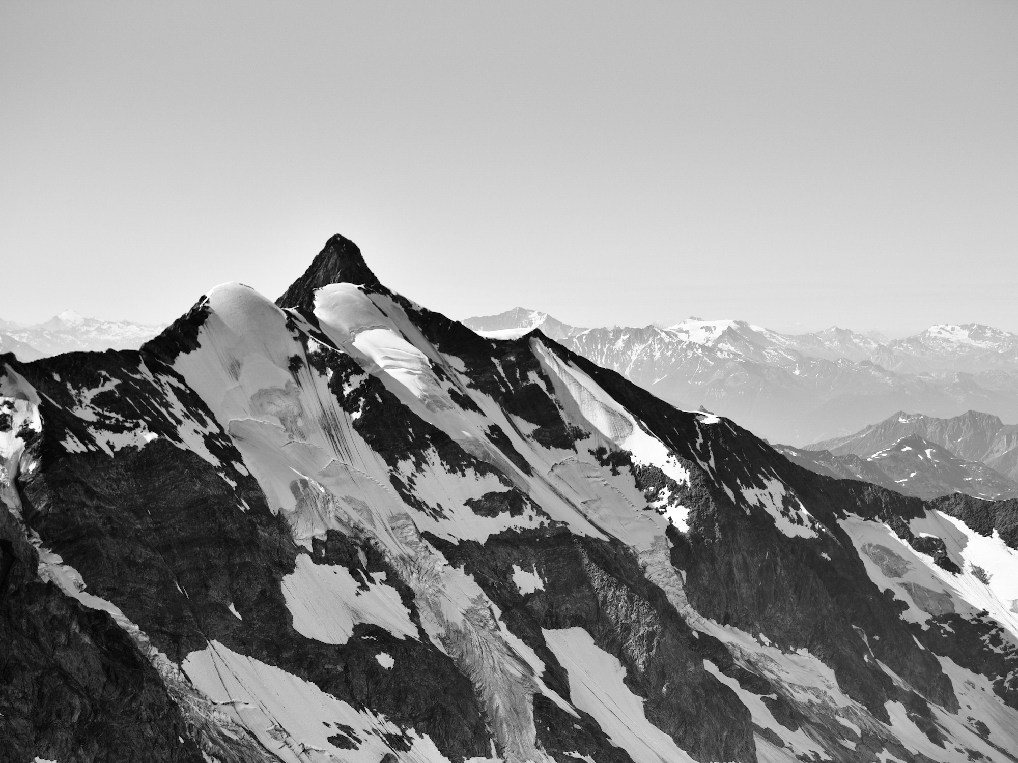 <blockquote> <p>The Aiguille Des Glaciers</p> <p><h6>Copyright © Adrien Jacquier Bret</h6></p> </blockquote> 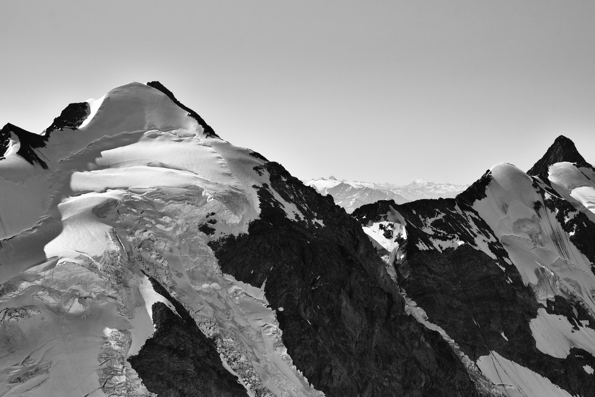 <blockquote> <p>Huge seracs of the Aiguille De Tré-La-Tête</p> <p><h6>Copyright © Adrien Jacquier Bret</h6></p> </blockquote> 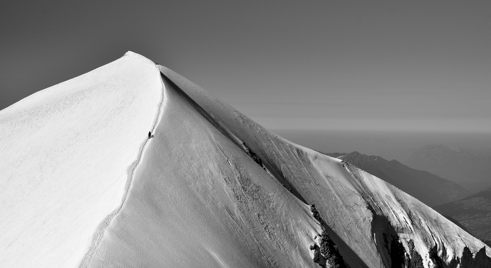 <blockquote> <p>What a beautiful summit ridge</p> <p><h6>Copyright © Adrien Jacquier Bret</h6></p> </blockquote> The next step is to climb that snow ridge, it is the highest summit of the five ones (3673m/12 050 ft.), then the summit behind, and to go down the mountain until the mountain pass of the Aiguille De La Bérangère. After a quite harsh and long walk we finally arrive, exhausted, at a mountain pass where we are looking for possibilities to go through a shortcut by the Glacier d’Armancette. We eventually end up going by the casual route of Aiguille de la Bérangère not knowing if the ice-field would be practicable or not. So we are climbing the Aiguille De La Bérangère that is, by the way, a dangerous way to go down because of the instability of the rocks, and the absence of any rock piton to get safe, but we finally reached the summit, and climbed down the mountain until arriving at the second refuge to rest a little bit before returning to the initial point. 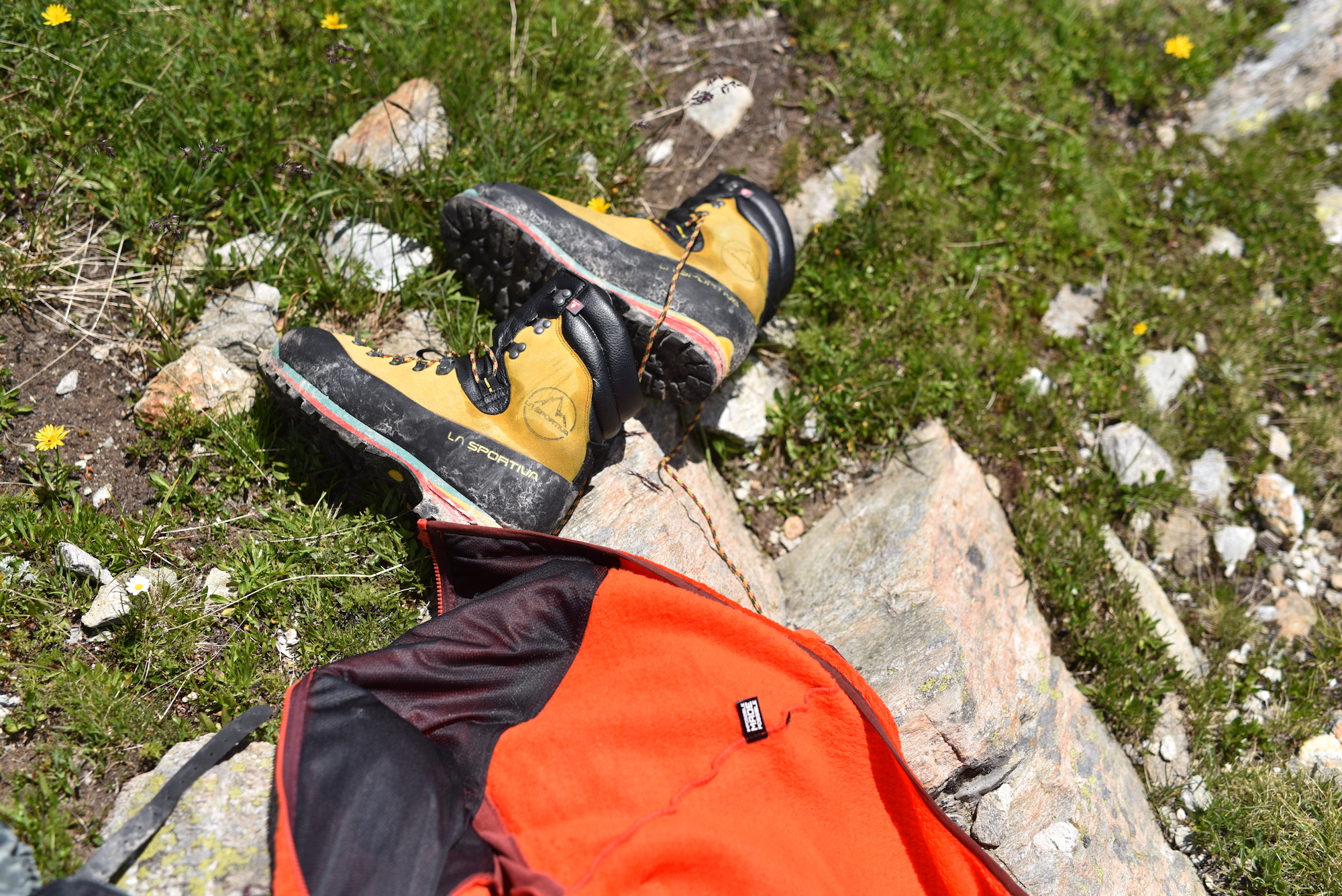 <blockquote> <p>Our stuff after the race, quiet tired</p> <p><h6>Copyright © Adrien Jacquier Bret</h6></p> </blockquote>  <blockquote> <p>Arrival at the refuge, clothes are drying under the sun</p> <p><h6>Copyright © Adrien Jacquier Bret</h6></p> </blockquote> It's now time to go to the first Refuge De Tré-La-Tête and then to the car, near Les Contamines-Montjoie. Exhausted, hungry and a bit burned by the sun, we finally achieve to go back home thinking of how harsh and long this race was. But what a beautiful journey ! Photo Credit © : Adrien Jacquier Bret / Clément Fivel Video Credit © : Clément Fivel Photography/Video gear : Nikon D750 + Sigma Art 50mm f/1.4 - GoPro Hero 5 <hr> # TRADUCTION FRANÇAISE / FRENCH TRANSLATION # Dômes De Miage (Massif du Mont Blanc) - Course en 2 jours ## 18/07/2018 - 18 Juillet 2018  <strong><h2><b>Détails</h2></strong> https://www.visorando.com/img/fiches/duree.png Durée : 20h https://www.visorando.com/img/fiches/distance.png Distance : 28.5km https://www.visorando.com/img/fiches/denivele-plus.png Dénivelé positif : 3624m (11 889 ft.) https://www.visorando.com/img/fiches/denivele-moins.png Dénivelé négatif : 3617m (11 866 ft.) https://www.visorando.com/img/fiches/point-haut.png Point haut : 3670m (12 040 ft.) https://www.visorando.com/img/fiches/point-bas.png Point bas : 1180m (3871 ft.) https://www.visorando.com/img/fiches/difficulte-tres-difficile.png Cotation d’alpinisme : PD II (Peu difficile) L’objectif de cette semaine était l’ascension des Dômes de Miage, sommet culminant à 3673m dans le massif du Mont Blanc. Cette course d’alpinisme est renommée pour la beauté de son arrête sommitale ainsi que sa facilité technique lorsque le temps le permet et la course pas trop glissante. Malgré une cotation PD (peu difficile), certains passages n’en demeurent pas moins dangereux pour des débutants ou des gens non habitués aux compétences de la montagne. Notre équipe est donc composée de mon frère et moi-même (respectivement Thibaud et Adrien Jacquier Bret), et de notre ami Clément Fivel qui fera office de guide, étant bien plus expérimenté que nous le sommes en haute montagne. https://youtu.be/nCQsvERaQ-0 <blockquote> <p>Le film final de notre course</p> <p><h6>Copyright © Clément Fivel</h6></p> </blockquote> Nous débutons la phase d’approche à Les Contamines-Montjoie jusqu’au premier refuge et étape de moyenne montagne, le Refuge de Tré-La-Tête (1970m), à côté du quel nous mangeons et nous reposons avant de reprendre la route pour le second refuge. L’itinéraire que nous devons suivre afin d’y parvenir est d’abord assez difficile, raide, rocailleux et parsemé de passages à cordes fixes mais devient par la suite plus praticable en serpentant longtemps le long du glacier. Nous arrivons ensuite à une passerelle Himalayenne de 60m de long, permettant de traverser un important gouffre donnant sur la dernière partie du trek et deuxième refuge.  <blockquote> <p>Durant la marche entre les deux refuges</p> <p><h6>Copyright © Clément Fivel</h6></p> </blockquote> https://youtu.be/IyJk7-eeBhg <blockquote> <p>La passerelle himalayenne</p> <p><h6>Copyright © Clément Fivel</h6></p> </blockquote> C’est après une dernière et fatigante marche que nous arrivons au Refuge des Conscrits (2610m), un grand établissement construit en 1997 (deuxième édition de l’édifice) surplombant l’impressionnant glacier de Tré-La-Tête que nous avons côtoyé toute la journée. Le refuge est le plus imposant des environs de Tré-La-Tête, le rendant extrêmement peuplé et demandé, et est de fait le point de départ de la majorité des marches et courses de la région avec notamment la fameuse Voie Royale, passant des Dômes de Miage à l’Aguille de Bionnassay pour finalement terminer au sommet du Mont Blanc. Le soleil va pour se coucher lorsque nous sommes étonnés par l’architecture de l’édifice, son isolement, et bientôt nous sommes vivifiés à l’idée de s’assoir et de se réchauffer. Peu après avoir posé nos affaires et payé la reservation, le temps magnifique nous permit de fumer une cigarette accompagnée d’une belle bière en terrasse et finir cette éprouvante journée de marche sur un repas et un sommeil bien mérités.  <blockquote> <p>Refuge Des Conscrits (2610m)</p> <p><h6>Copyright © Adrien Jacquier Bret</h6></p> </blockquote> Il est 3h00 du matin lorsque nous nous extirpons de nos confortables couches pour prendre une bref petit-déjeuner (en fait, une partie de nos rations pour le repas de midi et le souper), enfiler nos habits de haute montagne et notre équipement. C’est vers 4h30 que, casques et lumières frontales prêt à emplois, nous débutons enfin la tant attendu ascension. Nous progressons d’abord sur de la roche glissante et de la neige gelé avant de finalement chausser nos crampons aux abords du glacier. Le glacier de Tré-La-Tête, long de sept kilomètres, est le troisième plus grand glacier de France et du massif du Mont-Blanc. Dû à son isolement, sa difficulté d’accès et son bon nombre de crevasse il reste l’un des glaciers les moins étudiés de la communauté scientifique, et chaque année on dénote l’influence du réchauffement climatique par une réduction toujours plus importante de son étendue. Il est 5h00 lorsque l’équipe progresse avec difficulté, principalement dû aux formes que prend la neige; le vent ayant solidifié celle-ci en couches successive de vagues gelées, elle nous contraint maintenant à placer nos pas au sommet de chaque sculptures, nous épuisant les jambes. Notre peine est régulièrement balayé par le spectacle que nous offre cette magnifique vallée de neige pure, éternelle, et élevant nos regards aux timides et faibles premières lueurs d’un jour cotonneux caressant les sommets voisins, rien n’aurait pu nous défaire de cet agréable sentiment de plénitude, et de ce silence.  <blockquote> <p>Première lumières venant de l’Est du glacier</p> <p><h6>Copyright © Adrien Jacquier Bret</h6></p> </blockquote> Il est maintenant temps d’être plus alerte de nos mouvements afin de traverser en sécurité les nombreuses crevasses et tester la fiabilité des ponts de neige. Il est aussi le temps de souffrir un peu plus lors de l’ascension du Col Infranchissable (3350m) et de ressentir les premières baisses significatives de température (-6/-9°C), l’effet wind chill rendant l’atmosphère d’autant plus mordante. Nous finissons enfin par atteindre les premiers rayons de soleil aux abords de l’interminable et fatiguant Col des Dômes (3564m), qui en son sommet, nous dispense d’une vue imprenable sur la vallée de Passy, les montagnes Aravis et de notre point de départ de Les Contamines-Montjoie. https://youtu.be/xAIrr55wwjo <blockquote> <p>Une profonde crevasse durant l’ascension</p> <p><h6>Copyright © Clément Fivel</h6></p> </blockquote>  <blockquote> <p>Vue sur la vallée</p> <p><h6>Copyright © Adrien Jacquier Bret</h6></p> </blockquote>  <blockquote> <p>La pente bien raide menant au Col des Dômes</p> <p><h6>Copyright © Adrien Jacquier Bret</h6></p> </blockquote>  <blockquote> <p>Adrien</p> <p><h6>Copyright © Adrien Jacquier Bret</h6></p> </blockquote>  <blockquote> <p>Clément, notre compagnon de cordée</p> <p><h6>Copyright © Adrien Jacquier Bret</h6></p> </blockquote>  <blockquote> <p>Thibaud</p> <p><h6>Copyright © Adrien Jacquier Bret</h6></p> </blockquote> Quelques bares de céréales et une volée de clichés plus tard, nous escaladons désormais une pente raide entièrement constituée de glace (à 45° par endroits). Une voie délicate mais nécessaire pour atteindre le sommet. A notre arrivée, un magnifique panorama se dévoile à nos yeux émerveillés. Le Mont-Blanc, colosse magnifique et tranquille, s’élève sous le soleil du matin tandis que l’Aguille de Bionnassay nous offre une face sud-ouest escarpée et nue. La Voie Royale se déroule désormais devant nous. Nous sommes d’autant impressionnés par les seracs gigantesques de l’Aguille de Tré-La-Tête, prêts à s’effondrer et découpant la neige de profondes cicatrices noires emprisonnant la lumière. La beauté de notre périple consistera finalement grandement en la traversée de la mythique arrête sommitale s’élançant à l’assaut des derniers dômes (on décompte cinq sommet distincts).  <blockquote> <p>Vue sur l’Aiguille de Bionnassay et le Dôme du Goûter d’où se dessine le Mont Blanc </p> <p><h6>Copyright © Adrien Jacquier Bret</h6></p> </blockquote>  <blockquote> <p>L’Aiguille des Glaciers</p> <p><h6>Copyright © Adrien Jacquier Bret</h6></p> </blockquote>  <blockquote> <p>Séracs géants de l’Aiguille de Tré-La-Tête</p> <p><h6>Copyright © Adrien Jacquier Bret</h6></p> </blockquote>  <blockquote> <p>Quelle magnifique crête sommitale</p> <p><h6>Copyright © Adrien Jacquier Bret</h6></p> </blockquote> La prochaine étape consiste donc en l’ascension de l’arrête afin d’atteindre le point culminant des Dômes de Miage à 3673m. Une fois avoir profité un dernier moment de l’instant et laissant le sommet derrière nous, nous descendons désormais vers l’Aiguille de la Bérangère. Après une longue et épuisante marche nous arrivons finalement à un col de montagne où nous avons la possibilité d’emprunter un raccourcis par le Glacier d’Armancette. Nous décidons finalement d’emprunter la voie normale par l’Aiguille de la Bérangère ne voulant pas nous risquer à un terrain peut-être non praticable. Nous escaladons maintenant l’Aiguille de la Bérangère qui se révèle finalement être un passage dangereux vers la descente au refuge à cause des roches extrêmement friables dont la route est faite. Sans système d’assurance ni pitons disponibles nous finissons par arriver au sommet pour ensuite désescalader l’édifice et entamer la descente par les névés jusqu’au second refuge où nous nous reposerons quelques temps, avant d’entamer la dernière partie de notre marche vers la voiture.  <blockquote> <p>Notre matériel après la course, quelque peu fatigué</p> <p><h6>Copyright © Adrien Jacquier Bret</h6></p> </blockquote>  <blockquote> <p>Arrivée au refuge, les vêtements sèchent au soleil</p> <p><h6>Copyright © Adrien Jacquier Bret</h6></p> </blockquote> Il est maintenant temps de rejoindre le Refuge de Tré-La-Tête, puis notre voiture toujours parquée à Les Contamines-Montjoie. Épuisés, affamés et quelque peu brûlés par le soleil, nous réussissons finalement par rejoindre nos domiciles respectifs nous félicitant d’avoir accompli une course longue et plutôt endurante . Mais quelle magnifique course ! Credit Photo © : Adrien Jacquier Bret / Clément Fivel Credit Vidéo © : Clément Fivel Matériel Photo/Vidéo : Nikon D750 + Sigma Art 50mm f/1.4 - GoPro Hero 5 |
| json metadata | {"tags":["fr","en","travel","sport","mountaineering"],"image":["https://cdn.steemitimages.com/DQmeHcuFLDhBhnHLwnsQoNtPrnRvbZvvD3DXnUqGMTPXthh/Sans%20titre%20-%201.png","https://www.visorando.com/img/fiches/duree.png","https://www.visorando.com/img/fiches/distance.png","https://www.visorando.com/img/fiches/denivele-plus.png","https://www.visorando.com/img/fiches/denivele-moins.png","https://www.visorando.com/img/fiches/point-haut.png","https://www.visorando.com/img/fiches/point-bas.png","https://www.visorando.com/img/fiches/difficulte-tres-difficile.png","https://img.youtube.com/vi/nCQsvERaQ-0/0.jpg","https://cdn.steemitimages.com/DQmSX4xRt6uS7GAB2tT4cNJdAT6fQs8WTuDoVTvjZCMePqQ/image.png","https://img.youtube.com/vi/IyJk7-eeBhg/0.jpg","https://cdn.steemitimages.com/DQmNSnSK4M3vjLgS1UJY8L8Jsta2VFUdA2XLcFVYpvr26Q6/S06_1924.JPG","https://cdn.steemitimages.com/DQmeieuamxJa5ihvr4o8p44kgPPj3gphK7bBi6Ewau1D2zw/S06_1841.jpg","https://img.youtube.com/vi/xAIrr55wwjo/0.jpg","https://cdn.steemitimages.com/DQmZCNn6E6FrBMBEugdbxMKds74PHYQFkxBwLJvJa4SH8Qj/S06_1866.jpg","https://cdn.steemitimages.com/DQmSpjrTBegFozVGmgMR3rFig1g2FM5kK6DV7fC3mHs72zd/S06_1900.JPG","https://cdn.steemitimages.com/DQmbPKfnGDXbZPEMqfxRuduHidfESx49WwppTHtKQt3RyU6/S06_1892.jpg","https://cdn.steemitimages.com/DQmeZ9amdpLLKdEfDJWNUj926d8U5m5czRirPKPAC6udq9E/S06_1876.jpg","https://cdn.steemitimages.com/DQmRCJGj1XPHKyoSynL9yVBAYFaN3iUa18N2yfxUzySmz1L/S06_1885.jpg","https://cdn.steemitimages.com/DQmaEA9v9W5Ui8iHXPeMcEhCrqkL9e5gSUrjqGTjjdDh9ht/S06_1911.jpg","https://cdn.steemitimages.com/DQmPwGpnaqJUBGBBZ8tdDnFv72Lg9ePAEZ7VknPMdk1oZHS/S06_1909.jpg","https://cdn.steemitimages.com/DQme3GbHNMyH8VU3xyHpDotRoJRuVqZh3xBfRjR1ja9MtnK/S06_1903.jpg","https://cdn.steemitimages.com/DQmahVQcKrRydGKmCRedF5VNXyGp6qGAMPv8Ujzi1GuZ8wo/S06_1905.jpg","https://cdn.steemitimages.com/DQmU4WJg178vePQpx9NPGeDgXcf3QDWTRFfc27qVQpKDQC5/S06_1928.JPG","https://cdn.steemitimages.com/DQmcAjfHJKbkyTX29B41CUrdRJ49kkQwnzK59uDjLWW3FvE/S06_1930.JPG","https://cdn.steemitimages.com/DQmPVUjJqPa5gLTVoixfGR87TSPmk4WLnzZv2NG3ypN6GoL/Sans%20titre%20-%20FR.png"],"links":["https://youtu.be/nCQsvERaQ-0","https://youtu.be/IyJk7-eeBhg","https://youtu.be/xAIrr55wwjo"],"app":"steemit/0.1","format":"markdown"} |
| Transaction Info | Block #25150485/Trx 2c6dfc233b7792b1dc68066c8bc27cf129b361ec |
View Raw JSON Data
{
"trx_id": "2c6dfc233b7792b1dc68066c8bc27cf129b361ec",
"block": 25150485,
"trx_in_block": 7,
"op_in_trx": 0,
"virtual_op": 0,
"timestamp": "2018-08-17T15:39:39",
"op": [
"comment",
{
"parent_author": "",
"parent_permlink": "mountaineering",
"author": "aedyn",
"permlink": "en-fr-domes-de-miage-mont-blanc-mountains-2-days-trip",
"title": "[EN/FR] Dômes De Miage (Mont Blanc Mountains) - 2 Days Trip",
"body": "# Dômes De Miage (Mont Blanc Mountains) - 2 Days Trip\n###### <b>TRADUCTION FRANÇAISE EN BAS DE PAGE (FRENCH TRANSLATION AT THE BOTTOM) </b>\n\n<strong><h2><b>Details</h2></strong>\nhttps://www.visorando.com/img/fiches/duree.png Duration : 20h\nhttps://www.visorando.com/img/fiches/distance.png Distance : 28.5km\nhttps://www.visorando.com/img/fiches/denivele-plus.png Ascending elevation : 3624m (11 889 ft.)\nhttps://www.visorando.com/img/fiches/denivele-moins.png Descending elevation : 3617m (11 866 ft.)\nhttps://www.visorando.com/img/fiches/point-haut.png Highest point : 3670m (12 040 ft.)\nhttps://www.visorando.com/img/fiches/point-bas.png Lowest point : 1180m (3871 ft.)\nhttps://www.visorando.com/img/fiches/difficulte-tres-difficile.png Mountaineering cotation : PD II (not much difficult)\n\n\nThe goal of the week is to climb the Dômes De Miage summit at 3673m (12 050 ft.), located in the Mont Blanc Mountains, it is a famous mountaineering race especially because of the beauty of the final snow ridge, and because of almost no technical skills required when the weather isn't bad or many routes aren't frozen or slippery. Despite the \"PD-\" (not much difficult) rating of the race, some places are still dangerous without being with someone a little bit skillful about mountaineering. Our team is composed of my brother and I, Thibaud and Adrien Jacquier Bret, and our teammate Clément Fivel, who already climbed some mountains and is a lot more experienced than we are, he will be our guide and leading climber.\n\nhttps://youtu.be/nCQsvERaQ-0\n<blockquote>\n<p>The final film of our trip</p>\n<p><h6>Copyright © Clément Fivel</h6></p>\n</blockquote>\n\n\nStarting from Les Contamines-Montjoie, we begin to hike until arriving at the first mid-mountain refuge, the Refuge De Tré-La-Tête (1970m/6463 ft.), next to which we ate our lunches and had some rest before heading to the second refuge. The itinerary we must follow to achieve this hike is pretty hard in the beginning, steep, rocky, and helped by fixed ropes, but then becomes flat and snaking, for a long time, until arriving at the 60m long (196 ft.) Passerelle Himalayenne (footbridge) crossing a huge gulf, before showing the last part of the hike, leading to the second refuge.\n\n\n<blockquote>\n<p>During the hike between the two refuges</p>\n<p><h6>Copyright © Clément Fivel</h6></p>\n</blockquote>\n\nhttps://youtu.be/IyJk7-eeBhg\n<blockquote>\n<p>The Passerelle Himalayenne</p>\n<p><h6>Copyright © Clément Fivel</h6></p>\n</blockquote>\n\nThen, after a last but hard walk because being exhausted, we arrived at the second refuge at about 2610m (8562 ft.) of altitude, the Refuge Des Conscrits, a large building built in 1997 (the old one is now destroyed) on the right edge of the huge Glacier De Tré-La-Tête next to which we hiked all day long.\nThe refuge is actually the most important one of the Tré-La-Tête area in this mountains, and also the most attended, from which many mountaineering races are starting, including the famous Voie Royale (Royal Path), crossing the Dômes De Miage and the Aiguille De Bionnassay to finally finish at the top of the Mont Blanc.\nApproaching the first rocks indicating the end of the day, we are first stricken by the escarpment of the structure, and the isolation of such a living place, but then, delighted by the perspective of a sit and a warm place.\nAfter having dropped all our stuff, payed our booking and being given slippers, the good weather lets us smoking a cigarette and drinking a fresh beer on the terrace before a meal and a short but comfortable night.\n\n\n<blockquote>\n<p>Refuge Des Conscrits (2610m)</p>\n<p><h6>Copyright © Adrien Jacquier Bret</h6></p>\n</blockquote>\n\n\nIt's now 3:00 a.m and we get up from our warm and cosy beds, get down to have a brief breakfast (in fact, a part of our rations for the lunch and meal) and to wear our mountaineering clothes and gear. At 4:30 a.m, helmets and headlamps put on, we're finally ready to start climbing and are beginning to walk on slippery rocks, before we put on our crampons when arriving on the glacier.\nThe Glacier De Tré-La-Tête, seven kilometers long, is the third biggest glacier in France and in the Mont Blanc Mountains, and is the one that has been the less studied by scientists because of its isolation and difficult access, it is, like every glacier in these mountains, full of crevasses, and shrinking every year because of global warming, making it more dangerous and uncertain for climbers.\nAt 6:00 a.m the team is now walking on hard snow, with a bit of difficulty due to the shape of it, solid snow waves graven by the wind, forcing us to make every step on the top of every ridge, and tiring a bit our legs. But we are also walking in a pure and beautiful valley of ice, looking at the shy and thin light of sunrise, while glowing sunbeams are slowly cuddling the summit of mountains, nothing could be more pleasant than this feeling, than this silence.\n\n\n<blockquote>\n<p>First lights coming from the East of the glacier</p>\n<p><h6>Copyright © Adrien Jacquier Bret</h6></p>\n</blockquote>\n\nIt's time for us to be more careful about our movements, especially because we had to pass a bunch of crevasses and to check the reliability of snow bridges. But it's also time to suffer a bit more while climbing the Col Infranchissable (Impassable Mountain Pass) (3350m/10 990 ft.) and to get colder at the top of it, because of the temperature (-6/-9°C // 15/21°F) and also because of the wind chill effect.\nBut we are finally reaching the sunbeams and are beginning to warm up during the ascent of the Col Des Dômes (3564m/11 692 ft.) that is endless and tiresome, but that is offering us a beautiful view of the whole Passy Valley, the Aravis Mountains and at the bottom of the mountain, Les Contamines-Montjoie.\n\nhttps://youtu.be/xAIrr55wwjo\n<blockquote>\n<p>A big crevasse during the ascent</p>\n<p><h6>Copyright © Clément Fivel</h6></p>\n</blockquote>\n\n\n<blockquote>\n<p>A view of the valley</p>\n<p><h6>Copyright © Adrien Jacquier Bret</h6></p>\n</blockquote>\n\n\n<blockquote>\n<p>The steep slope leading to the Col Des Dômes</p>\n<p><h6>Copyright © Adrien Jacquier Bret</h6></p>\n</blockquote>\n\n\n<blockquote>\n<p>Adrien</p>\n<p><h6>Copyright © Adrien Jacquier Bret</h6></p>\n</blockquote>\n\n\n<blockquote>\n<p>Clément, our teammate</p>\n<p><h6>Copyright © Adrien Jacquier Bret</h6></p>\n</blockquote>\n\n\n<blockquote>\n<p>Thibaud</p>\n<p><h6>Copyright © Adrien Jacquier Bret</h6></p>\n</blockquote>\n\nAfter a short break during which we ate a bit of fruit bars and took some pictures, we are now climbing a steep slope of ice (about 45° at some points), a dangerous but unavoidable way to reach the summit.\nWhen we arrive, a beautiful panorama is waiting for us, the Mont Blanc is shinning under the morning sun, standing in front of the world, proudly, the Aiguille De Bionnassay is offering us its South-West face whose steepness can't let the snow covering it, showing the way of the Voie Royale.\nWe are also amazed by the gigantic seracs of the Aiguille De Tré-La-Tête, nearly falling off the mountain and drawing deep and black lesions in the snow, but the beauty of our trip is mainly about the snow ridge that shows the way to the next and final summit (we count five different summits at the top of the mountain).\n\n\n<blockquote>\n<p>A view of the Aiguille De Bionnassay and the Dôme Du Goûter next to the Mont Blanc</p>\n<p><h6>Copyright © Adrien Jacquier Bret</h6></p>\n</blockquote>\n\n\n<blockquote>\n<p>The Aiguille Des Glaciers</p>\n<p><h6>Copyright © Adrien Jacquier Bret</h6></p>\n</blockquote>\n\n\n<blockquote>\n<p>Huge seracs of the Aiguille De Tré-La-Tête</p>\n<p><h6>Copyright © Adrien Jacquier Bret</h6></p>\n</blockquote>\n\n\n<blockquote>\n<p>What a beautiful summit ridge</p>\n<p><h6>Copyright © Adrien Jacquier Bret</h6></p>\n</blockquote>\n\nThe next step is to climb that snow ridge, it is the highest summit of the five ones (3673m/12 050 ft.), then the summit behind, and to go down the mountain until the mountain pass of the Aiguille De La Bérangère.\nAfter a quite harsh and long walk we finally arrive, exhausted, at a mountain pass where we are looking for possibilities to go through a shortcut by the Glacier d’Armancette. We eventually end up going by the casual route of Aiguille de la Bérangère not knowing if the ice-field would be practicable or not.\nSo we are climbing the Aiguille De La Bérangère that is, by the way, a dangerous way to go down because of the instability of the rocks, and the absence of any rock piton to get safe, but we finally reached the summit, and climbed down the mountain until arriving at the second refuge to rest a little bit before returning to the initial point.\n\n\n<blockquote>\n<p>Our stuff after the race, quiet tired</p>\n<p><h6>Copyright © Adrien Jacquier Bret</h6></p>\n</blockquote>\n\n\n<blockquote>\n<p>Arrival at the refuge, clothes are drying under the sun</p>\n<p><h6>Copyright © Adrien Jacquier Bret</h6></p>\n</blockquote>\n\n\nIt's now time to go to the first Refuge De Tré-La-Tête and then to the car, near Les Contamines-Montjoie. Exhausted, hungry and a bit burned by the sun, we finally achieve to go back home thinking of how harsh and long this race was. But what a beautiful journey ! \n\nPhoto Credit © : Adrien Jacquier Bret / Clément Fivel\nVideo Credit © : Clément Fivel\n\nPhotography/Video gear : Nikon D750 + Sigma Art 50mm f/1.4 - GoPro Hero 5\n\n\n<hr>\n\n\n# TRADUCTION FRANÇAISE / FRENCH TRANSLATION\n\n# Dômes De Miage (Massif du Mont Blanc) - Course en 2 jours\n## 18/07/2018 - 18 Juillet 2018\n\n\n\n<strong><h2><b>Détails</h2></strong>\nhttps://www.visorando.com/img/fiches/duree.png Durée : 20h\nhttps://www.visorando.com/img/fiches/distance.png Distance : 28.5km\nhttps://www.visorando.com/img/fiches/denivele-plus.png Dénivelé positif : 3624m (11 889 ft.)\nhttps://www.visorando.com/img/fiches/denivele-moins.png Dénivelé négatif : 3617m (11 866 ft.)\nhttps://www.visorando.com/img/fiches/point-haut.png Point haut : 3670m (12 040 ft.)\nhttps://www.visorando.com/img/fiches/point-bas.png Point bas : 1180m (3871 ft.)\nhttps://www.visorando.com/img/fiches/difficulte-tres-difficile.png Cotation d’alpinisme : PD II (Peu difficile)\n\n\nL’objectif de cette semaine était l’ascension des Dômes de Miage, sommet culminant à 3673m dans le massif du Mont Blanc. Cette course d’alpinisme est renommée pour la beauté de son arrête sommitale ainsi que sa facilité technique lorsque le temps le permet et la course pas trop glissante. Malgré une cotation PD (peu difficile), certains passages n’en demeurent pas moins dangereux pour des débutants ou des gens non habitués aux compétences de la montagne. Notre équipe est donc composée de mon frère et moi-même (respectivement Thibaud et Adrien Jacquier Bret), et de notre ami Clément Fivel qui fera office de guide, étant bien plus expérimenté que nous le sommes en haute montagne.\n\nhttps://youtu.be/nCQsvERaQ-0\n<blockquote>\n<p>Le film final de notre course</p>\n<p><h6>Copyright © Clément Fivel</h6></p>\n</blockquote>\n\n\nNous débutons la phase d’approche à Les Contamines-Montjoie jusqu’au premier refuge et étape de moyenne montagne, le Refuge de Tré-La-Tête (1970m), à côté du quel nous mangeons et nous reposons avant de reprendre la route pour le second refuge. L’itinéraire que nous devons suivre afin d’y parvenir est d’abord assez difficile, raide, rocailleux et parsemé de passages à cordes fixes mais devient par la suite plus praticable en serpentant longtemps le long du glacier. Nous arrivons ensuite à une passerelle Himalayenne de 60m de long, permettant de traverser un important gouffre donnant sur la dernière partie du trek et deuxième refuge.\n\n\n<blockquote>\n<p>Durant la marche entre les deux refuges</p>\n<p><h6>Copyright © Clément Fivel</h6></p>\n</blockquote>\n\nhttps://youtu.be/IyJk7-eeBhg\n<blockquote>\n<p>La passerelle himalayenne</p>\n<p><h6>Copyright © Clément Fivel</h6></p>\n</blockquote>\n\nC’est après une dernière et fatigante marche que nous arrivons au Refuge des Conscrits (2610m), un grand établissement construit en 1997 (deuxième édition de l’édifice) surplombant l’impressionnant glacier de Tré-La-Tête que nous avons côtoyé toute la journée.\nLe refuge est le plus imposant des environs de Tré-La-Tête, le rendant extrêmement peuplé et demandé, et est de fait le point de départ de la majorité des marches et courses de la région avec notamment la fameuse Voie Royale, passant des Dômes de Miage à l’Aguille de Bionnassay pour finalement terminer au sommet du Mont Blanc.\nLe soleil va pour se coucher lorsque nous sommes étonnés par l’architecture de l’édifice, son isolement, et bientôt nous sommes vivifiés à l’idée de s’assoir et de se réchauffer.\nPeu après avoir posé nos affaires et payé la reservation, le temps magnifique nous permit de fumer une cigarette accompagnée d’une belle bière en terrasse et finir cette éprouvante journée de marche sur un repas et un sommeil bien mérités.\n\n\n<blockquote>\n<p>Refuge Des Conscrits (2610m)</p>\n<p><h6>Copyright © Adrien Jacquier Bret</h6></p>\n</blockquote>\n\n\nIl est 3h00 du matin lorsque nous nous extirpons de nos confortables couches pour prendre une bref petit-déjeuner (en fait, une partie de nos rations pour le repas de midi et le souper), enfiler nos habits de haute montagne et notre équipement. C’est vers 4h30 que, casques et lumières frontales prêt à emplois, nous débutons enfin la tant attendu ascension. Nous progressons d’abord sur de la roche glissante et de la neige gelé avant de finalement chausser nos crampons aux abords du glacier.\nLe glacier de Tré-La-Tête, long de sept kilomètres, est le troisième plus grand glacier de France et du massif du Mont-Blanc. Dû à son isolement, sa difficulté d’accès et son bon nombre de crevasse il reste l’un des glaciers les moins étudiés de la communauté scientifique, et chaque année on dénote l’influence du réchauffement climatique par une réduction toujours plus importante de son étendue.\nIl est 5h00 lorsque l’équipe progresse avec difficulté, principalement dû aux formes que prend la neige; le vent ayant solidifié celle-ci en couches successive de vagues gelées, elle nous contraint maintenant à placer nos pas au sommet de chaque sculptures, nous épuisant les jambes. Notre peine est régulièrement balayé par le spectacle que nous offre cette magnifique vallée de neige pure, éternelle, et élevant nos regards aux timides et faibles premières lueurs d’un jour cotonneux caressant les sommets voisins, rien n’aurait pu nous défaire de cet agréable sentiment de plénitude, et de ce silence.\n\n\n<blockquote>\n<p>Première lumières venant de l’Est du glacier</p>\n<p><h6>Copyright © Adrien Jacquier Bret</h6></p>\n</blockquote>\n\nIl est maintenant temps d’être plus alerte de nos mouvements afin de traverser en sécurité les nombreuses crevasses et tester la fiabilité des ponts de neige. Il est aussi le temps de souffrir un peu plus lors de l’ascension du Col Infranchissable (3350m) et de ressentir les premières baisses significatives de température (-6/-9°C), l’effet wind chill rendant l’atmosphère d’autant plus mordante.\nNous finissons enfin par atteindre les premiers rayons de soleil aux abords de l’interminable et fatiguant Col des Dômes (3564m), qui en son sommet, nous dispense d’une vue imprenable sur la vallée de Passy, les montagnes Aravis et de notre point de départ de Les Contamines-Montjoie.\n\nhttps://youtu.be/xAIrr55wwjo\n<blockquote>\n<p>Une profonde crevasse durant l’ascension</p>\n<p><h6>Copyright © Clément Fivel</h6></p>\n</blockquote>\n\n\n<blockquote>\n<p>Vue sur la vallée</p>\n<p><h6>Copyright © Adrien Jacquier Bret</h6></p>\n</blockquote>\n\n\n<blockquote>\n<p>La pente bien raide menant au Col des Dômes</p>\n<p><h6>Copyright © Adrien Jacquier Bret</h6></p>\n</blockquote>\n\n\n<blockquote>\n<p>Adrien</p>\n<p><h6>Copyright © Adrien Jacquier Bret</h6></p>\n</blockquote>\n\n\n<blockquote>\n<p>Clément, notre compagnon de cordée</p>\n<p><h6>Copyright © Adrien Jacquier Bret</h6></p>\n</blockquote>\n\n\n<blockquote>\n<p>Thibaud</p>\n<p><h6>Copyright © Adrien Jacquier Bret</h6></p>\n</blockquote>\n\nQuelques bares de céréales et une volée de clichés plus tard, nous escaladons désormais une pente raide entièrement constituée de glace (à 45° par endroits). Une voie délicate mais nécessaire pour atteindre le sommet.\nA notre arrivée, un magnifique panorama se dévoile à nos yeux émerveillés. Le Mont-Blanc, colosse magnifique et tranquille, s’élève sous le soleil du matin tandis que l’Aguille de Bionnassay nous offre une face sud-ouest escarpée et nue. La Voie Royale se déroule désormais devant nous.\nNous sommes d’autant impressionnés par les seracs gigantesques de l’Aguille de Tré-La-Tête, prêts à s’effondrer et découpant la neige de profondes cicatrices noires emprisonnant la lumière. La beauté de notre périple consistera finalement grandement en la traversée de la mythique arrête sommitale s’élançant à l’assaut des derniers dômes (on décompte cinq sommet distincts).\n\n\n<blockquote>\n<p>Vue sur l’Aiguille de Bionnassay et le Dôme du Goûter d’où se dessine le Mont Blanc </p>\n<p><h6>Copyright © Adrien Jacquier Bret</h6></p>\n</blockquote>\n\n\n<blockquote>\n<p>L’Aiguille des Glaciers</p>\n<p><h6>Copyright © Adrien Jacquier Bret</h6></p>\n</blockquote>\n\n\n<blockquote>\n<p>Séracs géants de l’Aiguille de Tré-La-Tête</p>\n<p><h6>Copyright © Adrien Jacquier Bret</h6></p>\n</blockquote>\n\n\n<blockquote>\n<p>Quelle magnifique crête sommitale</p>\n<p><h6>Copyright © Adrien Jacquier Bret</h6></p>\n</blockquote>\n\nLa prochaine étape consiste donc en l’ascension de l’arrête afin d’atteindre le point culminant des Dômes de Miage à 3673m. Une fois avoir profité un dernier moment de l’instant et laissant le sommet derrière nous, nous descendons désormais vers l’Aiguille de la Bérangère.\nAprès une longue et épuisante marche nous arrivons finalement à un col de montagne où nous avons la possibilité d’emprunter un raccourcis par le Glacier d’Armancette. Nous décidons finalement d’emprunter la voie normale par l’Aiguille de la Bérangère ne voulant pas nous risquer à un terrain peut-être non praticable.\nNous escaladons maintenant l’Aiguille de la Bérangère qui se révèle finalement être un passage dangereux vers la descente au refuge à cause des roches extrêmement friables dont la route est faite. Sans système d’assurance ni pitons disponibles nous finissons par arriver au sommet pour ensuite désescalader l’édifice et entamer la descente par les névés jusqu’au second refuge où nous nous reposerons quelques temps, avant d’entamer la dernière partie de notre marche vers la voiture.\n\n\n<blockquote>\n<p>Notre matériel après la course, quelque peu fatigué</p>\n<p><h6>Copyright © Adrien Jacquier Bret</h6></p>\n</blockquote>\n\n\n<blockquote>\n<p>Arrivée au refuge, les vêtements sèchent au soleil</p>\n<p><h6>Copyright © Adrien Jacquier Bret</h6></p>\n</blockquote>\n\n\nIl est maintenant temps de rejoindre le Refuge de Tré-La-Tête, puis notre voiture toujours parquée à Les Contamines-Montjoie. Épuisés, affamés et quelque peu brûlés par le soleil, nous réussissons finalement par rejoindre nos domiciles respectifs nous félicitant d’avoir accompli une course longue et plutôt endurante . Mais quelle magnifique course !\n\n\nCredit Photo © : Adrien Jacquier Bret / Clément Fivel\nCredit Vidéo © : Clément Fivel\n\nMatériel Photo/Vidéo : Nikon D750 + Sigma Art 50mm f/1.4 - GoPro Hero 5",
"json_metadata": "{\"tags\":[\"fr\",\"en\",\"travel\",\"sport\",\"mountaineering\"],\"image\":[\"https://cdn.steemitimages.com/DQmeHcuFLDhBhnHLwnsQoNtPrnRvbZvvD3DXnUqGMTPXthh/Sans%20titre%20-%201.png\",\"https://www.visorando.com/img/fiches/duree.png\",\"https://www.visorando.com/img/fiches/distance.png\",\"https://www.visorando.com/img/fiches/denivele-plus.png\",\"https://www.visorando.com/img/fiches/denivele-moins.png\",\"https://www.visorando.com/img/fiches/point-haut.png\",\"https://www.visorando.com/img/fiches/point-bas.png\",\"https://www.visorando.com/img/fiches/difficulte-tres-difficile.png\",\"https://img.youtube.com/vi/nCQsvERaQ-0/0.jpg\",\"https://cdn.steemitimages.com/DQmSX4xRt6uS7GAB2tT4cNJdAT6fQs8WTuDoVTvjZCMePqQ/image.png\",\"https://img.youtube.com/vi/IyJk7-eeBhg/0.jpg\",\"https://cdn.steemitimages.com/DQmNSnSK4M3vjLgS1UJY8L8Jsta2VFUdA2XLcFVYpvr26Q6/S06_1924.JPG\",\"https://cdn.steemitimages.com/DQmeieuamxJa5ihvr4o8p44kgPPj3gphK7bBi6Ewau1D2zw/S06_1841.jpg\",\"https://img.youtube.com/vi/xAIrr55wwjo/0.jpg\",\"https://cdn.steemitimages.com/DQmZCNn6E6FrBMBEugdbxMKds74PHYQFkxBwLJvJa4SH8Qj/S06_1866.jpg\",\"https://cdn.steemitimages.com/DQmSpjrTBegFozVGmgMR3rFig1g2FM5kK6DV7fC3mHs72zd/S06_1900.JPG\",\"https://cdn.steemitimages.com/DQmbPKfnGDXbZPEMqfxRuduHidfESx49WwppTHtKQt3RyU6/S06_1892.jpg\",\"https://cdn.steemitimages.com/DQmeZ9amdpLLKdEfDJWNUj926d8U5m5czRirPKPAC6udq9E/S06_1876.jpg\",\"https://cdn.steemitimages.com/DQmRCJGj1XPHKyoSynL9yVBAYFaN3iUa18N2yfxUzySmz1L/S06_1885.jpg\",\"https://cdn.steemitimages.com/DQmaEA9v9W5Ui8iHXPeMcEhCrqkL9e5gSUrjqGTjjdDh9ht/S06_1911.jpg\",\"https://cdn.steemitimages.com/DQmPwGpnaqJUBGBBZ8tdDnFv72Lg9ePAEZ7VknPMdk1oZHS/S06_1909.jpg\",\"https://cdn.steemitimages.com/DQme3GbHNMyH8VU3xyHpDotRoJRuVqZh3xBfRjR1ja9MtnK/S06_1903.jpg\",\"https://cdn.steemitimages.com/DQmahVQcKrRydGKmCRedF5VNXyGp6qGAMPv8Ujzi1GuZ8wo/S06_1905.jpg\",\"https://cdn.steemitimages.com/DQmU4WJg178vePQpx9NPGeDgXcf3QDWTRFfc27qVQpKDQC5/S06_1928.JPG\",\"https://cdn.steemitimages.com/DQmcAjfHJKbkyTX29B41CUrdRJ49kkQwnzK59uDjLWW3FvE/S06_1930.JPG\",\"https://cdn.steemitimages.com/DQmPVUjJqPa5gLTVoixfGR87TSPmk4WLnzZv2NG3ypN6GoL/Sans%20titre%20-%20FR.png\"],\"links\":[\"https://youtu.be/nCQsvERaQ-0\",\"https://youtu.be/IyJk7-eeBhg\",\"https://youtu.be/xAIrr55wwjo\"],\"app\":\"steemit/0.1\",\"format\":\"markdown\"}"
}
]
}aedynpublished a new post: en-fr-domes-de-miage-mont-blanc-mountains-2-days-trip2018/08/17 15:38:27
aedynpublished a new post: en-fr-domes-de-miage-mont-blanc-mountains-2-days-trip
2018/08/17 15:38:27
| parent author | |
| parent permlink | mountaineering |
| author | aedyn |
| permlink | en-fr-domes-de-miage-mont-blanc-mountains-2-days-trip |
| title | [EN/FR] Dômes De Miage (Mont Blanc Mountains) - 2 Days Trip |
| body | # Dômes De Miage (Mont Blanc Mountains) - 2 Days Trip ###### <b>TRADUCTION FRANÇAISE EN BAS DE PAGE (FRENCH TRANSLATION AT THE BOTTOM) </b>  <strong><h2><b>Details</h2></strong> https://www.visorando.com/img/fiches/duree.png Duration : 20h https://www.visorando.com/img/fiches/distance.png Distance : 28.5km https://www.visorando.com/img/fiches/denivele-plus.png Ascending elevation : 3624m (11 889 ft.) https://www.visorando.com/img/fiches/denivele-moins.png Descending elevation : 3617m (11 866 ft.) https://www.visorando.com/img/fiches/point-haut.png Highest point : 3670m (12 040 ft.) https://www.visorando.com/img/fiches/point-bas.png Lowest point : 1180m (3871 ft.) https://www.visorando.com/img/fiches/difficulte-tres-difficile.png Mountaineering cotation : PD II (not much difficult) The goal of the week is to climb the Dômes De Miage summit at 3673m (12 050 ft.), located in the Mont Blanc Mountains, it is a famous mountaineering race especially because of the beauty of the final snow ridge, and because of almost no technical skills required when the weather isn't bad or many routes aren't frozen or slippery. Despite the "PD-" (not much difficult) rating of the race, some places are still dangerous without being with someone a little bit skillful about mountaineering. Our team is composed of my brother and I, Thibaud and Adrien Jacquier Bret, and our teammate Clément Fivel, who already climbed some mountains and is a lot more experienced than we are, he will be our guide and leading climber. https://youtu.be/nCQsvERaQ-0 <blockquote> <p>The final film of our trip</p> <p><h6>Copyright © Clément Fivel</h6></p> </blockquote> Starting from Les Contamines-Montjoie, we begin to hike until arriving at the first mid-mountain refuge, the Refuge De Tré-La-Tête (1970m/6463 ft.), next to which we ate our lunches and had some rest before heading to the second refuge. The itinerary we must follow to achieve this hike is pretty hard in the beginning, steep, rocky, and helped by fixed ropes, but then becomes flat and snaking, for a long time, until arriving at the 60m long (196 ft.) Passerelle Himalayenne (footbridge) crossing a huge gulf, before showing the last part of the hike, leading to the second refuge.  <blockquote> <p>During the hike between the two refuges</p> <p><h6>Copyright © Clément Fivel</h6></p> </blockquote> https://youtu.be/IyJk7-eeBhg <blockquote> <p>The Passerelle Himalayenne</p> <p><h6>Copyright © Clément Fivel</h6></p> </blockquote> Then, after a last but hard walk because being exhausted, we arrived at the second refuge at about 2610m (8562 ft.) of altitude, the Refuge Des Conscrits, a large building built in 1997 (the old one is now destroyed) on the right edge of the huge Glacier De Tré-La-Tête next to which we hiked all day long. The refuge is actually the most important one of the Tré-La-Tête area in this mountains, and also the most attended, from which many mountaineering races are starting, including the famous Voie Royale (Royal Path), crossing the Dômes De Miage and the Aiguille De Bionnassay to finally finish at the top of the Mont Blanc. Approaching the first rocks indicating the end of the day, we are first stricken by the escarpment of the structure, and the isolation of such a living place, but then, delighted by the perspective of a sit and a warm place. After having dropped all our stuff, payed our booking and being given slippers, the good weather lets us smoking a cigarette and drinking a fresh beer on the terrace before a meal and a short but comfortable night.  <blockquote> <p>Refuge Des Conscrits (2610m)</p> <p><h6>Copyright © Adrien Jacquier Bret</h6></p> </blockquote> It's now 3:00 a.m and we get up from our warm and cosy beds, get down to have a brief breakfast (in fact, a part of our rations for the lunch and meal) and to wear our mountaineering clothes and gear. At 4:30 a.m, helmets and headlamps put on, we're finally ready to start climbing and are beginning to walk on slippery rocks, before we put on our crampons when arriving on the glacier. The Glacier De Tré-La-Tête, seven kilometers long, is the third biggest glacier in France and in the Mont Blanc Mountains, and is the one that has been the less studied by scientists because of its isolation and difficult access, it is, like every glacier in these mountains, full of crevasses, and shrinking every year because of global warming, making it more dangerous and uncertain for climbers. At 6:00 a.m the team is now walking on hard snow, with a bit of difficulty due to the shape of it, solid snow waves graven by the wind, forcing us to make every step on the top of every ridge, and tiring a bit our legs. But we are also walking in a pure and beautiful valley of ice, looking at the shy and thin light of sunrise, while glowing sunbeams are slowly cuddling the summit of mountains, nothing could be more pleasant than this feeling, than this silence.  <blockquote> <p>First lights coming from the East of the glacier</p> <p><h6>Copyright © Adrien Jacquier Bret</h6></p> </blockquote> It's time for us to be more careful about our movements, especially because we had to pass a bunch of crevasses and to check the reliability of snow bridges. But it's also time to suffer a bit more while climbing the Col Infranchissable (Impassable Mountain Pass) (3350m/10 990 ft.) and to get colder at the top of it, because of the temperature (-6/-9°C // 15/21°F) and also because of the wind chill effect. But we are finally reaching the sunbeams and are beginning to warm up during the ascent of the Col Des Dômes (3564m/11 692 ft.) that is endless and tiresome, but that is offering us a beautiful view of the whole Passy Valley, the Aravis Mountains and at the bottom of the mountain, Les Contamines-Montjoie. https://youtu.be/xAIrr55wwjo <blockquote> <p>A big crevasse during the ascent</p> <p><h6>Copyright © Clément Fivel</h6></p> </blockquote>  <blockquote> <p>A view of the valley</p> <p><h6>Copyright © Adrien Jacquier Bret</h6></p> </blockquote>  <blockquote> <p>The steep slope leading to the Col Des Dômes</p> <p><h6>Copyright © Adrien Jacquier Bret</h6></p> </blockquote>  <blockquote> <p>Adrien</p> <p><h6>Copyright © Adrien Jacquier Bret</h6></p> </blockquote>  <blockquote> <p>Clément, our teammate</p> <p><h6>Copyright © Adrien Jacquier Bret</h6></p> </blockquote>  <blockquote> <p>Thibaud</p> <p><h6>Copyright © Adrien Jacquier Bret</h6></p> </blockquote> After a short break during which we ate a bit of fruit bars and took some pictures, we are now climbing a steep slope of ice (about 45° at some points), a dangerous but unavoidable way to reach the summit. When we arrive, a beautiful panorama is waiting for us, the Mont Blanc is shinning under the morning sun, standing in front of the world, proudly, the Aiguille De Bionnassay is offering us its South-West face whose steepness can't let the snow covering it, showing the way of the Voie Royale. We are also amazed by the gigantic seracs of the Aiguille De Tré-La-Tête, nearly falling off the mountain and drawing deep and black lesions in the snow, but the beauty of our trip is mainly about the snow ridge that shows the way to the next and final summit (we count five different summits at the top of the mountain).  <blockquote> <p>A view of the Aiguille De Bionnassay and the Dôme Du Goûter next to the Mont Blanc</p> <p><h6>Copyright © Adrien Jacquier Bret</h6></p> </blockquote>  <blockquote> <p>The Aiguille Des Glaciers</p> <p><h6>Copyright © Adrien Jacquier Bret</h6></p> </blockquote>  <blockquote> <p>Huge seracs of the Aiguille De Tré-La-Tête</p> <p><h6>Copyright © Adrien Jacquier Bret</h6></p> </blockquote>  <blockquote> <p>What a beautiful summit ridge</p> <p><h6>Copyright © Adrien Jacquier Bret</h6></p> </blockquote> The next step is to climb that snow ridge, it is the highest summit of the five ones (3673m/12 050 ft.), then the summit behind, and to go down the mountain until the mountain pass of the Aiguille De La Bérangère. After a quite harsh and long walk we finally arrive, exhausted, at a mountain pass where we are looking for possibilities to go through a shortcut by the Glacier d’Armancette. We eventually end up going by the casual route of Aiguille de la Bérangère not knowing if the ice-field would be practicable or not. So we are climbing the Aiguille De La Bérangère that is, by the way, a dangerous way to go down because of the instability of the rocks, and the absence of any rock piton to get safe, but we finally reached the summit, and climbed down the mountain until arriving at the second refuge to rest a little bit before returning to the initial point.  <blockquote> <p>Our stuff after the race, quiet tired</p> <p><h6>Copyright © Adrien Jacquier Bret</h6></p> </blockquote>  <blockquote> <p>Arrival at the refuge, clothes are drying under the sun</p> <p><h6>Copyright © Adrien Jacquier Bret</h6></p> </blockquote> It's now time to go to the first Refuge De Tré-La-Tête and then to the car, near Les Contamines-Montjoie. Exhausted, hungry and a bit burned by the sun, we finally achieve to go back home thinking of how harsh and long this race was. But what a beautiful journey ! Photo Credit © : Adrien Jacquier Bret / Clément Fivel Video Credit © : Clément Fivel Photography/Video gear : Nikon D750 + Sigma Art 50mm f/1.4 - GoPro Hero 5 <hr> # TRADUCTION FRANÇAISE / FRENCH TRANSLATION # Dômes De Miage (Massif du Mont Blanc) - Course en 2 jours ## 18/07/2018 - 18 Juillet 2018  <strong><h2><b>Détails</h2></strong> https://www.visorando.com/img/fiches/duree.png Durée : 20h https://www.visorando.com/img/fiches/distance.png Distance : 28.5km https://www.visorando.com/img/fiches/denivele-plus.png Dénivelé positif : 3624m (11 889 ft.) https://www.visorando.com/img/fiches/denivele-moins.png Dénivelé négatif : 3617m (11 866 ft.) https://www.visorando.com/img/fiches/point-haut.png Point haut : 3670m (12 040 ft.) https://www.visorando.com/img/fiches/point-bas.png Point bas : 1180m (3871 ft.) https://www.visorando.com/img/fiches/difficulte-tres-difficile.png Cotation d’alpinisme : PD II (Peu difficile) L’objectif de cette semaine était l’ascension des Dômes de Miage, sommet culminant à 3673m dans le massif du Mont Blanc. Cette course d’alpinisme est renommée pour la beauté de son arrête sommitale ainsi que sa facilité technique lorsque le temps le permet et la course pas trop glissante. Malgré une cotation PD (peu difficile), certains passages n’en demeurent pas moins dangereux pour des débutants ou des gens non habitués aux compétences de la montagne. Notre équipe est donc composée de mon frère et moi-même (respectivement Thibaud et Adrien Jacquier Bret), et de notre ami Clément Fivel qui fera office de guide, étant bien plus expérimenté que nous le sommes en haute montagne. https://youtu.be/nCQsvERaQ-0 <blockquote> <p>Le film final de notre course</p> <p><h6>Copyright © Clément Fivel</h6></p> </blockquote> Nous débutons la phase d’approche à Les Contamines-Montjoie jusqu’au premier refuge et étape de moyenne montagne, le Refuge de Tré-La-Tête (1970m), à côté du quel nous mangeons et nous reposons avant de reprendre la route pour le second refuge. L’itinéraire que nous devons suivre afin d’y parvenir est d’abord assez difficile, raide, rocailleux et parsemé de passages à cordes fixes mais devient par la suite plus praticable en serpentant longtemps le long du glacier. Nous arrivons ensuite à une passerelle Himalayenne de 60m de long, permettant de traverser un important gouffre donnant sur la dernière partie du trek et deuxième refuge.  <blockquote> <p>Durant la marche entre les deux refuges</p> <p><h6>Copyright © Clément Fivel</h6></p> </blockquote> https://youtu.be/IyJk7-eeBhg <blockquote> <p>La passerelle himalayenne</p> <p><h6>Copyright © Clément Fivel</h6></p> </blockquote> C’est après une dernière et fatigante marche que nous arrivons au Refuge des Conscrits (2610m), un grand établissement construit en 1997 (deuxième édition de l’édifice) surplombant l’impressionnant glacier de Tré-La-Tête que nous avons côtoyé toute la journée. Le refuge est le plus imposant des environs de Tré-La-Tête, le rendant extrêmement peuplé et demandé, et est de fait le point de départ de la majorité des marches et courses de la région avec notamment la fameuse Voie Royale, passant des Dômes de Miage à l’Aguille de Bionnassay pour finalement terminer au sommet du Mont Blanc. Le soleil va pour se coucher lorsque nous sommes étonnés par l’architecture de l’édifice, son isolement, et bientôt nous sommes vivifiés à l’idée de s’assoir et de se réchauffer. Peu après avoir posé nos affaires et payé la reservation, le temps magnifique nous permit de fumer une cigarette accompagnée d’une belle bière en terrasse et finir cette éprouvante journée de marche sur un repas et un sommeil bien mérités.  <blockquote> <p>Refuge Des Conscrits (2610m)</p> <p><h6>Copyright © Adrien Jacquier Bret</h6></p> </blockquote> Il est 3h00 du matin lorsque nous nous extirpons de nos confortables couches pour prendre une bref petit-déjeuner (en fait, une partie de nos rations pour le repas de midi et le souper), enfiler nos habits de haute montagne et notre équipement. C’est vers 4h30 que, casques et lumières frontales prêt à emplois, nous débutons enfin la tant attendu ascension. Nous progressons d’abord sur de la roche glissante et de la neige gelé avant de finalement chausser nos crampons aux abords du glacier. Le glacier de Tré-La-Tête, long de sept kilomètres, est le troisième plus grand glacier de France et du massif du Mont-Blanc. Dû à son isolement, sa difficulté d’accès et son bon nombre de crevasse il reste l’un des glaciers les moins étudiés de la communauté scientifique, et chaque année on dénote l’influence du réchauffement climatique par une réduction toujours plus importante de son étendue. Il est 5h00 lorsque l’équipe progresse avec difficulté, principalement dû aux formes que prend la neige; le vent ayant solidifié celle-ci en couches successive de vagues gelées, elle nous contraint maintenant à placer nos pas au sommet de chaque sculptures, nous épuisant les jambes. Notre peine est régulièrement balayé par le spectacle que nous offre cette magnifique vallée de neige pure, éternelle, et élevant nos regards aux timides et faibles premières lueurs d’un jour cotonneux caressant les sommets voisins, rien n’aurait pu nous défaire de cet agréable sentiment de plénitude, et de ce silence.  <blockquote> <p>Première lumières venant de l’Est du glacier</p> <p><h6>Copyright © Adrien Jacquier Bret</h6></p> </blockquote> Il est maintenant temps d’être plus alerte de nos mouvements afin de traverser en sécurité les nombreuses crevasses et tester la fiabilité des ponts de neige. Il est aussi le temps de souffrir un peu plus lors de l’ascension du Col Infranchissable (3350m) et de ressentir les premières baisses significatives de température (-6/-9°C), l’effet wind chill rendant l’atmosphère d’autant plus mordante. Nous finissons enfin par atteindre les premiers rayons de soleil aux abords de l’interminable et fatiguant Col des Dômes (3564m), qui en son sommet, nous dispense d’une vue imprenable sur la vallée de Passy, les montagnes Aravis et de notre point de départ de Les Contamines-Montjoie. https://youtu.be/xAIrr55wwjo <blockquote> <p>Une profonde crevasse durant l’ascension</p> <p><h6>Copyright © Clément Fivel</h6></p> </blockquote>  <blockquote> <p>Vue sur la vallée</p> <p><h6>Copyright © Adrien Jacquier Bret</h6></p> </blockquote>  <blockquote> <p>La pente bien raide menant au Col des Dômes</p> <p><h6>Copyright © Adrien Jacquier Bret</h6></p> </blockquote>  <blockquote> <p>Adrien</p> <p><h6>Copyright © Adrien Jacquier Bret</h6></p> </blockquote>  <blockquote> <p>Clément, notre compagnon de cordée</p> <p><h6>Copyright © Adrien Jacquier Bret</h6></p> </blockquote>  <blockquote> <p>Thibaud</p> <p><h6>Copyright © Adrien Jacquier Bret</h6></p> </blockquote> Quelques bares de céréales et une volée de clichés plus tard, nous escaladons désormais une pente raide entièrement constituée de glace (à 45° par endroits). Une voie délicate mais nécessaire pour atteindre le sommet. A notre arrivée, un magnifique panorama se dévoile à nos yeux émerveillés. Le Mont-Blanc, colosse magnifique et tranquille, s’élève sous le soleil du matin tandis que l’Aguille de Bionnassay nous offre une face sud-ouest escarpée et nue. La Voie Royale se déroule désormais devant nous. Nous sommes d’autant impressionnés par les seracs gigantesques de l’Aguille de Tré-La-Tête, prêts à s’effondrer et découpant la neige de profondes cicatrices noires emprisonnant la lumière. La beauté de notre périple consistera finalement grandement en la traversée de la mythique arrête sommitale s’élançant à l’assaut des derniers dômes (on décompte cinq sommet distincts).  <blockquote> <p>Vue sur l’Aiguille de Bionnassay et le Dôme du Goûter d’où se dessine le Mont Blanc </p> <p><h6>Copyright © Adrien Jacquier Bret</h6></p> </blockquote>  <blockquote> <p>L’Aiguille des Glaciers</p> <p><h6>Copyright © Adrien Jacquier Bret</h6></p> </blockquote>  <blockquote> <p>Séracs géants de l’Aiguille de Tré-La-Tête</p> <p><h6>Copyright © Adrien Jacquier Bret</h6></p> </blockquote>  <blockquote> <p>Quelle magnifique crête sommitale</p> <p><h6>Copyright © Adrien Jacquier Bret</h6></p> </blockquote> La prochaine étape consiste donc en l’ascension de l’arrête afin d’atteindre le point culminant des Dômes de Miage à 3673m. Une fois avoir profité un dernier moment de l’instant et laissant le sommet derrière nous, nous descendons désormais vers l’Aiguille de la Bérangère. Après une longue et épuisante marche nous arrivons finalement à un col de montagne où nous avons la possibilité d’emprunter un raccourcis par le Glacier d’Armancette. Nous décidons finalement d’emprunter la voie normale par l’Aiguille de la Bérangère ne voulant pas nous risquer à un terrain peut-être non praticable. Nous escaladons maintenant l’Aiguille de la Bérangère qui se révèle finalement être un passage dangereux vers la descente au refuge à cause des roches extrêmement friables dont la route est faite. Sans système d’assurance ni pitons disponibles nous finissons par arriver au sommet pour ensuite désescalader l’édifice et entamer la descente par les névés jusqu’au second refuge où nous nous reposerons quelques temps, avant d’entamer la dernière partie de notre marche vers la voiture.  <blockquote> <p>Notre matériel après la course, quelque peu fatigué</p> <p><h6>Copyright © Adrien Jacquier Bret</h6></p> </blockquote>  <blockquote> <p>Arrivée au refuge, les vêtements sèchent au soleil</p> <p><h6>Copyright © Adrien Jacquier Bret</h6></p> </blockquote> Il est maintenant temps de rejoindre le Refuge de Tré-La-Tête, puis notre voiture toujours parquée à Les Contamines-Montjoie. Épuisés, affamés et quelque peu brûlés par le soleil, nous réussissons finalement par rejoindre nos domiciles respectifs nous félicitant d’avoir accompli une course longue et plutôt endurante . Mais quelle magnifique course ! Credit Photo © : Adrien Jacquier Bret / Clément Fivel Credit Vidéo © : Clément Fivel Matériel Photo/Vidéo : Nikon D750 + Sigma Art 50mm f/1.4 - GoPro Hero 5 |
| json metadata | {"tags":["fr","en","mountaineering","travel","sport"],"image":["https://cdn.steemitimages.com/DQmeHcuFLDhBhnHLwnsQoNtPrnRvbZvvD3DXnUqGMTPXthh/Sans%20titre%20-%201.png","https://www.visorando.com/img/fiches/duree.png","https://www.visorando.com/img/fiches/distance.png","https://www.visorando.com/img/fiches/denivele-plus.png","https://www.visorando.com/img/fiches/denivele-moins.png","https://www.visorando.com/img/fiches/point-haut.png","https://www.visorando.com/img/fiches/point-bas.png","https://www.visorando.com/img/fiches/difficulte-tres-difficile.png","https://img.youtube.com/vi/nCQsvERaQ-0/0.jpg","https://cdn.steemitimages.com/DQmSX4xRt6uS7GAB2tT4cNJdAT6fQs8WTuDoVTvjZCMePqQ/image.png","https://img.youtube.com/vi/IyJk7-eeBhg/0.jpg","https://cdn.steemitimages.com/DQmNSnSK4M3vjLgS1UJY8L8Jsta2VFUdA2XLcFVYpvr26Q6/S06_1924.JPG","https://cdn.steemitimages.com/DQmeieuamxJa5ihvr4o8p44kgPPj3gphK7bBi6Ewau1D2zw/S06_1841.jpg","https://img.youtube.com/vi/xAIrr55wwjo/0.jpg","https://cdn.steemitimages.com/DQmZCNn6E6FrBMBEugdbxMKds74PHYQFkxBwLJvJa4SH8Qj/S06_1866.jpg","https://cdn.steemitimages.com/DQmSpjrTBegFozVGmgMR3rFig1g2FM5kK6DV7fC3mHs72zd/S06_1900.JPG","https://cdn.steemitimages.com/DQmbPKfnGDXbZPEMqfxRuduHidfESx49WwppTHtKQt3RyU6/S06_1892.jpg","https://cdn.steemitimages.com/DQmeZ9amdpLLKdEfDJWNUj926d8U5m5czRirPKPAC6udq9E/S06_1876.jpg","https://cdn.steemitimages.com/DQmRCJGj1XPHKyoSynL9yVBAYFaN3iUa18N2yfxUzySmz1L/S06_1885.jpg","https://cdn.steemitimages.com/DQmaEA9v9W5Ui8iHXPeMcEhCrqkL9e5gSUrjqGTjjdDh9ht/S06_1911.jpg","https://cdn.steemitimages.com/DQmPwGpnaqJUBGBBZ8tdDnFv72Lg9ePAEZ7VknPMdk1oZHS/S06_1909.jpg","https://cdn.steemitimages.com/DQme3GbHNMyH8VU3xyHpDotRoJRuVqZh3xBfRjR1ja9MtnK/S06_1903.jpg","https://cdn.steemitimages.com/DQmahVQcKrRydGKmCRedF5VNXyGp6qGAMPv8Ujzi1GuZ8wo/S06_1905.jpg","https://cdn.steemitimages.com/DQmU4WJg178vePQpx9NPGeDgXcf3QDWTRFfc27qVQpKDQC5/S06_1928.JPG","https://cdn.steemitimages.com/DQmcAjfHJKbkyTX29B41CUrdRJ49kkQwnzK59uDjLWW3FvE/S06_1930.JPG","https://cdn.steemitimages.com/DQmPVUjJqPa5gLTVoixfGR87TSPmk4WLnzZv2NG3ypN6GoL/Sans%20titre%20-%20FR.png"],"links":["https://youtu.be/nCQsvERaQ-0","https://youtu.be/IyJk7-eeBhg","https://youtu.be/xAIrr55wwjo"],"app":"steemit/0.1","format":"markdown"} |
| Transaction Info | Block #25150461/Trx b8c96b48b4faff6b15bfe34cbae28794618c51b8 |
View Raw JSON Data
{
"trx_id": "b8c96b48b4faff6b15bfe34cbae28794618c51b8",
"block": 25150461,
"trx_in_block": 48,
"op_in_trx": 0,
"virtual_op": 0,
"timestamp": "2018-08-17T15:38:27",
"op": [
"comment",
{
"parent_author": "",
"parent_permlink": "mountaineering",
"author": "aedyn",
"permlink": "en-fr-domes-de-miage-mont-blanc-mountains-2-days-trip",
"title": "[EN/FR] Dômes De Miage (Mont Blanc Mountains) - 2 Days Trip",
"body": "# Dômes De Miage (Mont Blanc Mountains) - 2 Days Trip\n###### <b>TRADUCTION FRANÇAISE EN BAS DE PAGE (FRENCH TRANSLATION AT THE BOTTOM) </b>\n\n<strong><h2><b>Details</h2></strong>\nhttps://www.visorando.com/img/fiches/duree.png Duration : 20h\nhttps://www.visorando.com/img/fiches/distance.png Distance : 28.5km\nhttps://www.visorando.com/img/fiches/denivele-plus.png Ascending elevation : 3624m (11 889 ft.)\nhttps://www.visorando.com/img/fiches/denivele-moins.png Descending elevation : 3617m (11 866 ft.)\nhttps://www.visorando.com/img/fiches/point-haut.png Highest point : 3670m (12 040 ft.)\nhttps://www.visorando.com/img/fiches/point-bas.png Lowest point : 1180m (3871 ft.)\nhttps://www.visorando.com/img/fiches/difficulte-tres-difficile.png Mountaineering cotation : PD II (not much difficult)\n\n\nThe goal of the week is to climb the Dômes De Miage summit at 3673m (12 050 ft.), located in the Mont Blanc Mountains, it is a famous mountaineering race especially because of the beauty of the final snow ridge, and because of almost no technical skills required when the weather isn't bad or many routes aren't frozen or slippery. Despite the \"PD-\" (not much difficult) rating of the race, some places are still dangerous without being with someone a little bit skillful about mountaineering. Our team is composed of my brother and I, Thibaud and Adrien Jacquier Bret, and our teammate Clément Fivel, who already climbed some mountains and is a lot more experienced than we are, he will be our guide and leading climber.\n\nhttps://youtu.be/nCQsvERaQ-0\n<blockquote>\n<p>The final film of our trip</p>\n<p><h6>Copyright © Clément Fivel</h6></p>\n</blockquote>\n\n\nStarting from Les Contamines-Montjoie, we begin to hike until arriving at the first mid-mountain refuge, the Refuge De Tré-La-Tête (1970m/6463 ft.), next to which we ate our lunches and had some rest before heading to the second refuge. The itinerary we must follow to achieve this hike is pretty hard in the beginning, steep, rocky, and helped by fixed ropes, but then becomes flat and snaking, for a long time, until arriving at the 60m long (196 ft.) Passerelle Himalayenne (footbridge) crossing a huge gulf, before showing the last part of the hike, leading to the second refuge.\n\n\n<blockquote>\n<p>During the hike between the two refuges</p>\n<p><h6>Copyright © Clément Fivel</h6></p>\n</blockquote>\n\nhttps://youtu.be/IyJk7-eeBhg\n<blockquote>\n<p>The Passerelle Himalayenne</p>\n<p><h6>Copyright © Clément Fivel</h6></p>\n</blockquote>\n\nThen, after a last but hard walk because being exhausted, we arrived at the second refuge at about 2610m (8562 ft.) of altitude, the Refuge Des Conscrits, a large building built in 1997 (the old one is now destroyed) on the right edge of the huge Glacier De Tré-La-Tête next to which we hiked all day long.\nThe refuge is actually the most important one of the Tré-La-Tête area in this mountains, and also the most attended, from which many mountaineering races are starting, including the famous Voie Royale (Royal Path), crossing the Dômes De Miage and the Aiguille De Bionnassay to finally finish at the top of the Mont Blanc.\nApproaching the first rocks indicating the end of the day, we are first stricken by the escarpment of the structure, and the isolation of such a living place, but then, delighted by the perspective of a sit and a warm place.\nAfter having dropped all our stuff, payed our booking and being given slippers, the good weather lets us smoking a cigarette and drinking a fresh beer on the terrace before a meal and a short but comfortable night.\n\n\n<blockquote>\n<p>Refuge Des Conscrits (2610m)</p>\n<p><h6>Copyright © Adrien Jacquier Bret</h6></p>\n</blockquote>\n\n\nIt's now 3:00 a.m and we get up from our warm and cosy beds, get down to have a brief breakfast (in fact, a part of our rations for the lunch and meal) and to wear our mountaineering clothes and gear. At 4:30 a.m, helmets and headlamps put on, we're finally ready to start climbing and are beginning to walk on slippery rocks, before we put on our crampons when arriving on the glacier.\nThe Glacier De Tré-La-Tête, seven kilometers long, is the third biggest glacier in France and in the Mont Blanc Mountains, and is the one that has been the less studied by scientists because of its isolation and difficult access, it is, like every glacier in these mountains, full of crevasses, and shrinking every year because of global warming, making it more dangerous and uncertain for climbers.\nAt 6:00 a.m the team is now walking on hard snow, with a bit of difficulty due to the shape of it, solid snow waves graven by the wind, forcing us to make every step on the top of every ridge, and tiring a bit our legs. But we are also walking in a pure and beautiful valley of ice, looking at the shy and thin light of sunrise, while glowing sunbeams are slowly cuddling the summit of mountains, nothing could be more pleasant than this feeling, than this silence.\n\n\n<blockquote>\n<p>First lights coming from the East of the glacier</p>\n<p><h6>Copyright © Adrien Jacquier Bret</h6></p>\n</blockquote>\n\nIt's time for us to be more careful about our movements, especially because we had to pass a bunch of crevasses and to check the reliability of snow bridges. But it's also time to suffer a bit more while climbing the Col Infranchissable (Impassable Mountain Pass) (3350m/10 990 ft.) and to get colder at the top of it, because of the temperature (-6/-9°C // 15/21°F) and also because of the wind chill effect.\nBut we are finally reaching the sunbeams and are beginning to warm up during the ascent of the Col Des Dômes (3564m/11 692 ft.) that is endless and tiresome, but that is offering us a beautiful view of the whole Passy Valley, the Aravis Mountains and at the bottom of the mountain, Les Contamines-Montjoie.\n\nhttps://youtu.be/xAIrr55wwjo\n<blockquote>\n<p>A big crevasse during the ascent</p>\n<p><h6>Copyright © Clément Fivel</h6></p>\n</blockquote>\n\n\n<blockquote>\n<p>A view of the valley</p>\n<p><h6>Copyright © Adrien Jacquier Bret</h6></p>\n</blockquote>\n\n\n<blockquote>\n<p>The steep slope leading to the Col Des Dômes</p>\n<p><h6>Copyright © Adrien Jacquier Bret</h6></p>\n</blockquote>\n\n\n<blockquote>\n<p>Adrien</p>\n<p><h6>Copyright © Adrien Jacquier Bret</h6></p>\n</blockquote>\n\n\n<blockquote>\n<p>Clément, our teammate</p>\n<p><h6>Copyright © Adrien Jacquier Bret</h6></p>\n</blockquote>\n\n\n<blockquote>\n<p>Thibaud</p>\n<p><h6>Copyright © Adrien Jacquier Bret</h6></p>\n</blockquote>\n\nAfter a short break during which we ate a bit of fruit bars and took some pictures, we are now climbing a steep slope of ice (about 45° at some points), a dangerous but unavoidable way to reach the summit.\nWhen we arrive, a beautiful panorama is waiting for us, the Mont Blanc is shinning under the morning sun, standing in front of the world, proudly, the Aiguille De Bionnassay is offering us its South-West face whose steepness can't let the snow covering it, showing the way of the Voie Royale.\nWe are also amazed by the gigantic seracs of the Aiguille De Tré-La-Tête, nearly falling off the mountain and drawing deep and black lesions in the snow, but the beauty of our trip is mainly about the snow ridge that shows the way to the next and final summit (we count five different summits at the top of the mountain).\n\n\n<blockquote>\n<p>A view of the Aiguille De Bionnassay and the Dôme Du Goûter next to the Mont Blanc</p>\n<p><h6>Copyright © Adrien Jacquier Bret</h6></p>\n</blockquote>\n\n\n<blockquote>\n<p>The Aiguille Des Glaciers</p>\n<p><h6>Copyright © Adrien Jacquier Bret</h6></p>\n</blockquote>\n\n\n<blockquote>\n<p>Huge seracs of the Aiguille De Tré-La-Tête</p>\n<p><h6>Copyright © Adrien Jacquier Bret</h6></p>\n</blockquote>\n\n\n<blockquote>\n<p>What a beautiful summit ridge</p>\n<p><h6>Copyright © Adrien Jacquier Bret</h6></p>\n</blockquote>\n\nThe next step is to climb that snow ridge, it is the highest summit of the five ones (3673m/12 050 ft.), then the summit behind, and to go down the mountain until the mountain pass of the Aiguille De La Bérangère.\nAfter a quite harsh and long walk we finally arrive, exhausted, at a mountain pass where we are looking for possibilities to go through a shortcut by the Glacier d’Armancette. We eventually end up going by the casual route of Aiguille de la Bérangère not knowing if the ice-field would be practicable or not.\nSo we are climbing the Aiguille De La Bérangère that is, by the way, a dangerous way to go down because of the instability of the rocks, and the absence of any rock piton to get safe, but we finally reached the summit, and climbed down the mountain until arriving at the second refuge to rest a little bit before returning to the initial point.\n\n\n<blockquote>\n<p>Our stuff after the race, quiet tired</p>\n<p><h6>Copyright © Adrien Jacquier Bret</h6></p>\n</blockquote>\n\n\n<blockquote>\n<p>Arrival at the refuge, clothes are drying under the sun</p>\n<p><h6>Copyright © Adrien Jacquier Bret</h6></p>\n</blockquote>\n\n\nIt's now time to go to the first Refuge De Tré-La-Tête and then to the car, near Les Contamines-Montjoie. Exhausted, hungry and a bit burned by the sun, we finally achieve to go back home thinking of how harsh and long this race was. But what a beautiful journey ! \n\nPhoto Credit © : Adrien Jacquier Bret / Clément Fivel\nVideo Credit © : Clément Fivel\n\nPhotography/Video gear : Nikon D750 + Sigma Art 50mm f/1.4 - GoPro Hero 5\n\n\n<hr>\n\n\n# TRADUCTION FRANÇAISE / FRENCH TRANSLATION\n\n# Dômes De Miage (Massif du Mont Blanc) - Course en 2 jours\n## 18/07/2018 - 18 Juillet 2018\n\n\n\n<strong><h2><b>Détails</h2></strong>\nhttps://www.visorando.com/img/fiches/duree.png Durée : 20h\nhttps://www.visorando.com/img/fiches/distance.png Distance : 28.5km\nhttps://www.visorando.com/img/fiches/denivele-plus.png Dénivelé positif : 3624m (11 889 ft.)\nhttps://www.visorando.com/img/fiches/denivele-moins.png Dénivelé négatif : 3617m (11 866 ft.)\nhttps://www.visorando.com/img/fiches/point-haut.png Point haut : 3670m (12 040 ft.)\nhttps://www.visorando.com/img/fiches/point-bas.png Point bas : 1180m (3871 ft.)\nhttps://www.visorando.com/img/fiches/difficulte-tres-difficile.png Cotation d’alpinisme : PD II (Peu difficile)\n\n\nL’objectif de cette semaine était l’ascension des Dômes de Miage, sommet culminant à 3673m dans le massif du Mont Blanc. Cette course d’alpinisme est renommée pour la beauté de son arrête sommitale ainsi que sa facilité technique lorsque le temps le permet et la course pas trop glissante. Malgré une cotation PD (peu difficile), certains passages n’en demeurent pas moins dangereux pour des débutants ou des gens non habitués aux compétences de la montagne. Notre équipe est donc composée de mon frère et moi-même (respectivement Thibaud et Adrien Jacquier Bret), et de notre ami Clément Fivel qui fera office de guide, étant bien plus expérimenté que nous le sommes en haute montagne.\n\nhttps://youtu.be/nCQsvERaQ-0\n<blockquote>\n<p>Le film final de notre course</p>\n<p><h6>Copyright © Clément Fivel</h6></p>\n</blockquote>\n\n\nNous débutons la phase d’approche à Les Contamines-Montjoie jusqu’au premier refuge et étape de moyenne montagne, le Refuge de Tré-La-Tête (1970m), à côté du quel nous mangeons et nous reposons avant de reprendre la route pour le second refuge. L’itinéraire que nous devons suivre afin d’y parvenir est d’abord assez difficile, raide, rocailleux et parsemé de passages à cordes fixes mais devient par la suite plus praticable en serpentant longtemps le long du glacier. Nous arrivons ensuite à une passerelle Himalayenne de 60m de long, permettant de traverser un important gouffre donnant sur la dernière partie du trek et deuxième refuge.\n\n\n<blockquote>\n<p>Durant la marche entre les deux refuges</p>\n<p><h6>Copyright © Clément Fivel</h6></p>\n</blockquote>\n\nhttps://youtu.be/IyJk7-eeBhg\n<blockquote>\n<p>La passerelle himalayenne</p>\n<p><h6>Copyright © Clément Fivel</h6></p>\n</blockquote>\n\nC’est après une dernière et fatigante marche que nous arrivons au Refuge des Conscrits (2610m), un grand établissement construit en 1997 (deuxième édition de l’édifice) surplombant l’impressionnant glacier de Tré-La-Tête que nous avons côtoyé toute la journée.\nLe refuge est le plus imposant des environs de Tré-La-Tête, le rendant extrêmement peuplé et demandé, et est de fait le point de départ de la majorité des marches et courses de la région avec notamment la fameuse Voie Royale, passant des Dômes de Miage à l’Aguille de Bionnassay pour finalement terminer au sommet du Mont Blanc.\nLe soleil va pour se coucher lorsque nous sommes étonnés par l’architecture de l’édifice, son isolement, et bientôt nous sommes vivifiés à l’idée de s’assoir et de se réchauffer.\nPeu après avoir posé nos affaires et payé la reservation, le temps magnifique nous permit de fumer une cigarette accompagnée d’une belle bière en terrasse et finir cette éprouvante journée de marche sur un repas et un sommeil bien mérités.\n\n\n<blockquote>\n<p>Refuge Des Conscrits (2610m)</p>\n<p><h6>Copyright © Adrien Jacquier Bret</h6></p>\n</blockquote>\n\n\nIl est 3h00 du matin lorsque nous nous extirpons de nos confortables couches pour prendre une bref petit-déjeuner (en fait, une partie de nos rations pour le repas de midi et le souper), enfiler nos habits de haute montagne et notre équipement. C’est vers 4h30 que, casques et lumières frontales prêt à emplois, nous débutons enfin la tant attendu ascension. Nous progressons d’abord sur de la roche glissante et de la neige gelé avant de finalement chausser nos crampons aux abords du glacier.\nLe glacier de Tré-La-Tête, long de sept kilomètres, est le troisième plus grand glacier de France et du massif du Mont-Blanc. Dû à son isolement, sa difficulté d’accès et son bon nombre de crevasse il reste l’un des glaciers les moins étudiés de la communauté scientifique, et chaque année on dénote l’influence du réchauffement climatique par une réduction toujours plus importante de son étendue.\nIl est 5h00 lorsque l’équipe progresse avec difficulté, principalement dû aux formes que prend la neige; le vent ayant solidifié celle-ci en couches successive de vagues gelées, elle nous contraint maintenant à placer nos pas au sommet de chaque sculptures, nous épuisant les jambes. Notre peine est régulièrement balayé par le spectacle que nous offre cette magnifique vallée de neige pure, éternelle, et élevant nos regards aux timides et faibles premières lueurs d’un jour cotonneux caressant les sommets voisins, rien n’aurait pu nous défaire de cet agréable sentiment de plénitude, et de ce silence.\n\n\n<blockquote>\n<p>Première lumières venant de l’Est du glacier</p>\n<p><h6>Copyright © Adrien Jacquier Bret</h6></p>\n</blockquote>\n\nIl est maintenant temps d’être plus alerte de nos mouvements afin de traverser en sécurité les nombreuses crevasses et tester la fiabilité des ponts de neige. Il est aussi le temps de souffrir un peu plus lors de l’ascension du Col Infranchissable (3350m) et de ressentir les premières baisses significatives de température (-6/-9°C), l’effet wind chill rendant l’atmosphère d’autant plus mordante.\nNous finissons enfin par atteindre les premiers rayons de soleil aux abords de l’interminable et fatiguant Col des Dômes (3564m), qui en son sommet, nous dispense d’une vue imprenable sur la vallée de Passy, les montagnes Aravis et de notre point de départ de Les Contamines-Montjoie.\n\nhttps://youtu.be/xAIrr55wwjo\n<blockquote>\n<p>Une profonde crevasse durant l’ascension</p>\n<p><h6>Copyright © Clément Fivel</h6></p>\n</blockquote>\n\n\n<blockquote>\n<p>Vue sur la vallée</p>\n<p><h6>Copyright © Adrien Jacquier Bret</h6></p>\n</blockquote>\n\n\n<blockquote>\n<p>La pente bien raide menant au Col des Dômes</p>\n<p><h6>Copyright © Adrien Jacquier Bret</h6></p>\n</blockquote>\n\n\n<blockquote>\n<p>Adrien</p>\n<p><h6>Copyright © Adrien Jacquier Bret</h6></p>\n</blockquote>\n\n\n<blockquote>\n<p>Clément, notre compagnon de cordée</p>\n<p><h6>Copyright © Adrien Jacquier Bret</h6></p>\n</blockquote>\n\n\n<blockquote>\n<p>Thibaud</p>\n<p><h6>Copyright © Adrien Jacquier Bret</h6></p>\n</blockquote>\n\nQuelques bares de céréales et une volée de clichés plus tard, nous escaladons désormais une pente raide entièrement constituée de glace (à 45° par endroits). Une voie délicate mais nécessaire pour atteindre le sommet.\nA notre arrivée, un magnifique panorama se dévoile à nos yeux émerveillés. Le Mont-Blanc, colosse magnifique et tranquille, s’élève sous le soleil du matin tandis que l’Aguille de Bionnassay nous offre une face sud-ouest escarpée et nue. La Voie Royale se déroule désormais devant nous.\nNous sommes d’autant impressionnés par les seracs gigantesques de l’Aguille de Tré-La-Tête, prêts à s’effondrer et découpant la neige de profondes cicatrices noires emprisonnant la lumière. La beauté de notre périple consistera finalement grandement en la traversée de la mythique arrête sommitale s’élançant à l’assaut des derniers dômes (on décompte cinq sommet distincts).\n\n\n<blockquote>\n<p>Vue sur l’Aiguille de Bionnassay et le Dôme du Goûter d’où se dessine le Mont Blanc </p>\n<p><h6>Copyright © Adrien Jacquier Bret</h6></p>\n</blockquote>\n\n\n<blockquote>\n<p>L’Aiguille des Glaciers</p>\n<p><h6>Copyright © Adrien Jacquier Bret</h6></p>\n</blockquote>\n\n\n<blockquote>\n<p>Séracs géants de l’Aiguille de Tré-La-Tête</p>\n<p><h6>Copyright © Adrien Jacquier Bret</h6></p>\n</blockquote>\n\n\n<blockquote>\n<p>Quelle magnifique crête sommitale</p>\n<p><h6>Copyright © Adrien Jacquier Bret</h6></p>\n</blockquote>\n\nLa prochaine étape consiste donc en l’ascension de l’arrête afin d’atteindre le point culminant des Dômes de Miage à 3673m. Une fois avoir profité un dernier moment de l’instant et laissant le sommet derrière nous, nous descendons désormais vers l’Aiguille de la Bérangère.\nAprès une longue et épuisante marche nous arrivons finalement à un col de montagne où nous avons la possibilité d’emprunter un raccourcis par le Glacier d’Armancette. Nous décidons finalement d’emprunter la voie normale par l’Aiguille de la Bérangère ne voulant pas nous risquer à un terrain peut-être non praticable.\nNous escaladons maintenant l’Aiguille de la Bérangère qui se révèle finalement être un passage dangereux vers la descente au refuge à cause des roches extrêmement friables dont la route est faite. Sans système d’assurance ni pitons disponibles nous finissons par arriver au sommet pour ensuite désescalader l’édifice et entamer la descente par les névés jusqu’au second refuge où nous nous reposerons quelques temps, avant d’entamer la dernière partie de notre marche vers la voiture.\n\n\n<blockquote>\n<p>Notre matériel après la course, quelque peu fatigué</p>\n<p><h6>Copyright © Adrien Jacquier Bret</h6></p>\n</blockquote>\n\n\n<blockquote>\n<p>Arrivée au refuge, les vêtements sèchent au soleil</p>\n<p><h6>Copyright © Adrien Jacquier Bret</h6></p>\n</blockquote>\n\n\nIl est maintenant temps de rejoindre le Refuge de Tré-La-Tête, puis notre voiture toujours parquée à Les Contamines-Montjoie. Épuisés, affamés et quelque peu brûlés par le soleil, nous réussissons finalement par rejoindre nos domiciles respectifs nous félicitant d’avoir accompli une course longue et plutôt endurante . Mais quelle magnifique course !\n\n\nCredit Photo © : Adrien Jacquier Bret / Clément Fivel\nCredit Vidéo © : Clément Fivel\n\nMatériel Photo/Vidéo : Nikon D750 + Sigma Art 50mm f/1.4 - GoPro Hero 5",
"json_metadata": "{\"tags\":[\"fr\",\"en\",\"mountaineering\",\"travel\",\"sport\"],\"image\":[\"https://cdn.steemitimages.com/DQmeHcuFLDhBhnHLwnsQoNtPrnRvbZvvD3DXnUqGMTPXthh/Sans%20titre%20-%201.png\",\"https://www.visorando.com/img/fiches/duree.png\",\"https://www.visorando.com/img/fiches/distance.png\",\"https://www.visorando.com/img/fiches/denivele-plus.png\",\"https://www.visorando.com/img/fiches/denivele-moins.png\",\"https://www.visorando.com/img/fiches/point-haut.png\",\"https://www.visorando.com/img/fiches/point-bas.png\",\"https://www.visorando.com/img/fiches/difficulte-tres-difficile.png\",\"https://img.youtube.com/vi/nCQsvERaQ-0/0.jpg\",\"https://cdn.steemitimages.com/DQmSX4xRt6uS7GAB2tT4cNJdAT6fQs8WTuDoVTvjZCMePqQ/image.png\",\"https://img.youtube.com/vi/IyJk7-eeBhg/0.jpg\",\"https://cdn.steemitimages.com/DQmNSnSK4M3vjLgS1UJY8L8Jsta2VFUdA2XLcFVYpvr26Q6/S06_1924.JPG\",\"https://cdn.steemitimages.com/DQmeieuamxJa5ihvr4o8p44kgPPj3gphK7bBi6Ewau1D2zw/S06_1841.jpg\",\"https://img.youtube.com/vi/xAIrr55wwjo/0.jpg\",\"https://cdn.steemitimages.com/DQmZCNn6E6FrBMBEugdbxMKds74PHYQFkxBwLJvJa4SH8Qj/S06_1866.jpg\",\"https://cdn.steemitimages.com/DQmSpjrTBegFozVGmgMR3rFig1g2FM5kK6DV7fC3mHs72zd/S06_1900.JPG\",\"https://cdn.steemitimages.com/DQmbPKfnGDXbZPEMqfxRuduHidfESx49WwppTHtKQt3RyU6/S06_1892.jpg\",\"https://cdn.steemitimages.com/DQmeZ9amdpLLKdEfDJWNUj926d8U5m5czRirPKPAC6udq9E/S06_1876.jpg\",\"https://cdn.steemitimages.com/DQmRCJGj1XPHKyoSynL9yVBAYFaN3iUa18N2yfxUzySmz1L/S06_1885.jpg\",\"https://cdn.steemitimages.com/DQmaEA9v9W5Ui8iHXPeMcEhCrqkL9e5gSUrjqGTjjdDh9ht/S06_1911.jpg\",\"https://cdn.steemitimages.com/DQmPwGpnaqJUBGBBZ8tdDnFv72Lg9ePAEZ7VknPMdk1oZHS/S06_1909.jpg\",\"https://cdn.steemitimages.com/DQme3GbHNMyH8VU3xyHpDotRoJRuVqZh3xBfRjR1ja9MtnK/S06_1903.jpg\",\"https://cdn.steemitimages.com/DQmahVQcKrRydGKmCRedF5VNXyGp6qGAMPv8Ujzi1GuZ8wo/S06_1905.jpg\",\"https://cdn.steemitimages.com/DQmU4WJg178vePQpx9NPGeDgXcf3QDWTRFfc27qVQpKDQC5/S06_1928.JPG\",\"https://cdn.steemitimages.com/DQmcAjfHJKbkyTX29B41CUrdRJ49kkQwnzK59uDjLWW3FvE/S06_1930.JPG\",\"https://cdn.steemitimages.com/DQmPVUjJqPa5gLTVoixfGR87TSPmk4WLnzZv2NG3ypN6GoL/Sans%20titre%20-%20FR.png\"],\"links\":[\"https://youtu.be/nCQsvERaQ-0\",\"https://youtu.be/IyJk7-eeBhg\",\"https://youtu.be/xAIrr55wwjo\"],\"app\":\"steemit/0.1\",\"format\":\"markdown\"}"
}
]
}aerithe77upvoted (100.00%) @aedyn / en-fr-domes-de-miage-mont-blanc-mountains-2-days-trip2018/08/17 15:22:42
aerithe77upvoted (100.00%) @aedyn / en-fr-domes-de-miage-mont-blanc-mountains-2-days-trip
2018/08/17 15:22:42
| voter | aerithe77 |
| author | aedyn |
| permlink | en-fr-domes-de-miage-mont-blanc-mountains-2-days-trip |
| weight | 10000 (100.00%) |
| Transaction Info | Block #25150146/Trx 608bf0d9f5008103b51773539f3aca62708d87f2 |
View Raw JSON Data
{
  "trx_id": "608bf0d9f5008103b51773539f3aca62708d87f2",
  "block": 25150146,
  "trx_in_block": 34,
  "op_in_trx": 0,
  "virtual_op": 0,
  "timestamp": "2018-08-17T15:22:42",
  "op": [
    "vote",
    {
      "voter": "aerithe77",
      "author": "aedyn",
      "permlink": "en-fr-domes-de-miage-mont-blanc-mountains-2-days-trip",
      "weight": 10000
    }
  ]
}aedynupvoted (100.00%) @hiranya / how-exercise-shapes-you-far-beyond-the-gym-201791t72849907z2018/08/17 14:12:54
aedynupvoted (100.00%) @hiranya / how-exercise-shapes-you-far-beyond-the-gym-201791t72849907z
2018/08/17 14:12:54
| voter | aedyn |
| author | hiranya |
| permlink | how-exercise-shapes-you-far-beyond-the-gym-201791t72849907z |
| weight | 10000 (100.00%) |
| Transaction Info | Block #25148751/Trx c54687fdfc48f97ba5fe0beb1e64e7ccb2c54c8e |
View Raw JSON Data
{
  "trx_id": "c54687fdfc48f97ba5fe0beb1e64e7ccb2c54c8e",
  "block": 25148751,
  "trx_in_block": 17,
  "op_in_trx": 0,
  "virtual_op": 0,
  "timestamp": "2018-08-17T14:12:54",
  "op": [
    "vote",
    {
      "voter": "aedyn",
      "author": "hiranya",
      "permlink": "how-exercise-shapes-you-far-beyond-the-gym-201791t72849907z",
      "weight": 10000
    }
  ]
}2018/08/17 14:07:57
2018/08/17 14:07:57
| voter | aedyn |
| author | steemitplayer |
| permlink | climber-completes-the-most-dangerous-rope-free-ascent-ever-2017819t112657485z |
| weight | 10000 (100.00%) |
| Transaction Info | Block #25148652/Trx 3fe6a16cae536913d3d1e8074680bdd30a22e1e9 |
View Raw JSON Data
{
  "trx_id": "3fe6a16cae536913d3d1e8074680bdd30a22e1e9",
  "block": 25148652,
  "trx_in_block": 4,
  "op_in_trx": 0,
  "virtual_op": 0,
  "timestamp": "2018-08-17T14:07:57",
  "op": [
    "vote",
    {
      "voter": "aedyn",
      "author": "steemitplayer",
      "permlink": "climber-completes-the-most-dangerous-rope-free-ascent-ever-2017819t112657485z",
      "weight": 10000
    }
  ]
}2018/08/17 14:06:18
2018/08/17 14:06:18
| parent author | luigiborla |
| parent permlink | mont-blanc-aiguille-du-midi-l-ingresso-per-la-montagna-piu-bella-del-mondo |
| author | aedyn |
| permlink | re-luigiborla-mont-blanc-aiguille-du-midi-l-ingresso-per-la-montagna-piu-bella-del-mondo-20180817t140617229z |
| title | |
| body | Sono parole che il mondo degli alpinisti dovrebbe ascoltare più spesso, bravo ! |
| json metadata | {"tags":["photography"],"app":"steemit/0.1"} |
| Transaction Info | Block #25148619/Trx bb66b4c1c2dc9f36dda734fda152bf9506d9cb83 |
View Raw JSON Data
{
  "trx_id": "bb66b4c1c2dc9f36dda734fda152bf9506d9cb83",
  "block": 25148619,
  "trx_in_block": 23,
  "op_in_trx": 0,
  "virtual_op": 0,
  "timestamp": "2018-08-17T14:06:18",
  "op": [
    "comment",
    {
      "parent_author": "luigiborla",
      "parent_permlink": "mont-blanc-aiguille-du-midi-l-ingresso-per-la-montagna-piu-bella-del-mondo",
      "author": "aedyn",
      "permlink": "re-luigiborla-mont-blanc-aiguille-du-midi-l-ingresso-per-la-montagna-piu-bella-del-mondo-20180817t140617229z",
      "title": "",
      "body": "Sono parole che il mondo degli alpinisti dovrebbe ascoltare più spesso, bravo !",
      "json_metadata": "{\"tags\":[\"photography\"],\"app\":\"steemit/0.1\"}"
    }
  ]
}2018/08/17 14:01:51
2018/08/17 14:01:51
| voter | aedyn |
| author | luigiborla |
| permlink | mont-blanc-aiguille-du-midi-l-ingresso-per-la-montagna-piu-bella-del-mondo |
| weight | 10000 (100.00%) |
| Transaction Info | Block #25148530/Trx 969da6abae4c473f28131e04880894ccbe88c0e7 |
View Raw JSON Data
{
  "trx_id": "969da6abae4c473f28131e04880894ccbe88c0e7",
  "block": 25148530,
  "trx_in_block": 23,
  "op_in_trx": 0,
  "virtual_op": 0,
  "timestamp": "2018-08-17T14:01:51",
  "op": [
    "vote",
    {
      "voter": "aedyn",
      "author": "luigiborla",
      "permlink": "mont-blanc-aiguille-du-midi-l-ingresso-per-la-montagna-piu-bella-del-mondo",
      "weight": 10000
    }
  ]
}2018/08/17 14:00:21
2018/08/17 14:00:21
| parent author | luigiborla |
| parent permlink | 2avgyd-gran-paradiso-north-face |
| author | aedyn |
| permlink | re-luigiborla-2avgyd-gran-paradiso-north-face-20180817t140020605z |
| title | |
| body | Great ! Can you tell me a bit more about the difficulty of the north face instead of the normal route ? |
| json metadata | {"tags":["photography"],"app":"steemit/0.1"} |
| Transaction Info | Block #25148500/Trx eccb10d93a0ae36f7e983815e9c29327d72f4270 |
View Raw JSON Data
{
  "trx_id": "eccb10d93a0ae36f7e983815e9c29327d72f4270",
  "block": 25148500,
  "trx_in_block": 19,
  "op_in_trx": 0,
  "virtual_op": 0,
  "timestamp": "2018-08-17T14:00:21",
  "op": [
    "comment",
    {
      "parent_author": "luigiborla",
      "parent_permlink": "2avgyd-gran-paradiso-north-face",
      "author": "aedyn",
      "permlink": "re-luigiborla-2avgyd-gran-paradiso-north-face-20180817t140020605z",
      "title": "",
      "body": "Great ! Can you tell me a bit more about the difficulty of the north face instead of the normal route ?",
      "json_metadata": "{\"tags\":[\"photography\"],\"app\":\"steemit/0.1\"}"
    }
  ]
}aedynupvoted (100.00%) @luigiborla / 2avgyd-gran-paradiso-north-face2018/08/17 13:59:03
aedynupvoted (100.00%) @luigiborla / 2avgyd-gran-paradiso-north-face
2018/08/17 13:59:03
| voter | aedyn |
| author | luigiborla |
| permlink | 2avgyd-gran-paradiso-north-face |
| weight | 10000 (100.00%) |
| Transaction Info | Block #25148474/Trx 8c117fe25f3830c5cf9f478c766af35e95bd0a4f |
View Raw JSON Data
{
  "trx_id": "8c117fe25f3830c5cf9f478c766af35e95bd0a4f",
  "block": 25148474,
  "trx_in_block": 11,
  "op_in_trx": 0,
  "virtual_op": 0,
  "timestamp": "2018-08-17T13:59:03",
  "op": [
    "vote",
    {
      "voter": "aedyn",
      "author": "luigiborla",
      "permlink": "2avgyd-gran-paradiso-north-face",
      "weight": 10000
    }
  ]
}aedynupvoted (100.00%) @luigiborla / cresta-del-gran-paradiso2018/08/17 13:58:30
aedynupvoted (100.00%) @luigiborla / cresta-del-gran-paradiso
2018/08/17 13:58:30
| voter | aedyn |
| author | luigiborla |
| permlink | cresta-del-gran-paradiso |
| weight | 10000 (100.00%) |
| Transaction Info | Block #25148463/Trx 25d0af0be69605ac1394c52a763b21ca689f6fdd |
View Raw JSON Data
{
  "trx_id": "25d0af0be69605ac1394c52a763b21ca689f6fdd",
  "block": 25148463,
  "trx_in_block": 18,
  "op_in_trx": 0,
  "virtual_op": 0,
  "timestamp": "2018-08-17T13:58:30",
  "op": [
    "vote",
    {
      "voter": "aedyn",
      "author": "luigiborla",
      "permlink": "cresta-del-gran-paradiso",
      "weight": 10000
    }
  ]
}aedynfollowed @luigiborla2018/08/17 13:58:12
aedynfollowed @luigiborla
2018/08/17 13:58:12
| required auths | [] |
| required posting auths | ["aedyn"] |
| id | follow |
| json | ["follow",{"follower":"aedyn","following":"luigiborla","what":["blog"]}] |
| Transaction Info | Block #25148457/Trx de2d6f24f68206751bde660de49f31cf442dc05b |
View Raw JSON Data
{
  "trx_id": "de2d6f24f68206751bde660de49f31cf442dc05b",
  "block": 25148457,
  "trx_in_block": 17,
  "op_in_trx": 0,
  "virtual_op": 0,
  "timestamp": "2018-08-17T13:58:12",
  "op": [
    "custom_json",
    {
      "required_auths": [],
      "required_posting_auths": [
        "aedyn"
      ],
      "id": "follow",
      "json": "[\"follow\",{\"follower\":\"aedyn\",\"following\":\"luigiborla\",\"what\":[\"blog\"]}]"
    }
  ]
}sensationupvoted (100.00%) @aedyn / en-fr-domes-de-miage-mont-blanc-mountains-2-days-trip2018/08/17 12:55:06
sensationupvoted (100.00%) @aedyn / en-fr-domes-de-miage-mont-blanc-mountains-2-days-trip
2018/08/17 12:55:06
| voter | sensation |
| author | aedyn |
| permlink | en-fr-domes-de-miage-mont-blanc-mountains-2-days-trip |
| weight | 10000 (100.00%) |
| Transaction Info | Block #25147195/Trx 6ee1d7679fcb5a93fa5a3ca9339bcd77b3ef651d |
View Raw JSON Data
{
  "trx_id": "6ee1d7679fcb5a93fa5a3ca9339bcd77b3ef651d",
  "block": 25147195,
  "trx_in_block": 9,
  "op_in_trx": 0,
  "virtual_op": 0,
  "timestamp": "2018-08-17T12:55:06",
  "op": [
    "vote",
    {
      "voter": "sensation",
      "author": "aedyn",
      "permlink": "en-fr-domes-de-miage-mont-blanc-mountains-2-days-trip",
      "weight": 10000
    }
  ]
}aedynupvoted (100.00%) @aedyn / en-fr-domes-de-miage-mont-blanc-mountains-2-days-trip2018/08/17 12:48:33
aedynupvoted (100.00%) @aedyn / en-fr-domes-de-miage-mont-blanc-mountains-2-days-trip
2018/08/17 12:48:33
| voter | aedyn |
| author | aedyn |
| permlink | en-fr-domes-de-miage-mont-blanc-mountains-2-days-trip |
| weight | 10000 (100.00%) |
| Transaction Info | Block #25147064/Trx 7892e4dacdda9188ceb512731ac0bdbbbe629faa |
View Raw JSON Data
{
  "trx_id": "7892e4dacdda9188ceb512731ac0bdbbbe629faa",
  "block": 25147064,
  "trx_in_block": 21,
  "op_in_trx": 0,
  "virtual_op": 0,
  "timestamp": "2018-08-17T12:48:33",
  "op": [
    "vote",
    {
      "voter": "aedyn",
      "author": "aedyn",
      "permlink": "en-fr-domes-de-miage-mont-blanc-mountains-2-days-trip",
      "weight": 10000
    }
  ]
}aedynupdated their account properties2018/08/17 12:46:18
aedynupdated their account properties
2018/08/17 12:46:18
| account | aedyn |
| memo key | STM4zsWoVnrKG5cBhJYzGoCvjj47ajpD8fcN9JnTgmzZ6F9bshFvS |
| json metadata | {"profile":{"name":"DharmaBrothers"}} |
| Transaction Info | Block #25147019/Trx ef8b8b5bdfc84f720dbc0c2b19d21faa24deae16 |
View Raw JSON Data
{
  "trx_id": "ef8b8b5bdfc84f720dbc0c2b19d21faa24deae16",
  "block": 25147019,
  "trx_in_block": 14,
  "op_in_trx": 0,
  "virtual_op": 0,
  "timestamp": "2018-08-17T12:46:18",
  "op": [
    "account_update",
    {
      "account": "aedyn",
      "memo_key": "STM4zsWoVnrKG5cBhJYzGoCvjj47ajpD8fcN9JnTgmzZ6F9bshFvS",
      "json_metadata": "{\"profile\":{\"name\":\"DharmaBrothers\"}}"
    }
  ]
}aedynfollowed @dharmablues2018/08/17 12:41:45
aedynfollowed @dharmablues
2018/08/17 12:41:45
| required auths | [] |
| required posting auths | ["aedyn"] |
| id | follow |
| json | ["follow",{"follower":"aedyn","following":"dharmablues","what":["blog"]}] |
| Transaction Info | Block #25146928/Trx 9e8c6f03a1ba32fc7157f4115b5d9907cb2f1a4f |
View Raw JSON Data
{
  "trx_id": "9e8c6f03a1ba32fc7157f4115b5d9907cb2f1a4f",
  "block": 25146928,
  "trx_in_block": 11,
  "op_in_trx": 0,
  "virtual_op": 0,
  "timestamp": "2018-08-17T12:41:45",
  "op": [
    "custom_json",
    {
      "required_auths": [],
      "required_posting_auths": [
        "aedyn"
      ],
      "id": "follow",
      "json": "[\"follow\",{\"follower\":\"aedyn\",\"following\":\"dharmablues\",\"what\":[\"blog\"]}]"
    }
  ]
}dharmabluesupvoted (100.00%) @aedyn / en-fr-domes-de-miage-mont-blanc-mountains-2-days-trip2018/08/17 12:10:21
dharmabluesupvoted (100.00%) @aedyn / en-fr-domes-de-miage-mont-blanc-mountains-2-days-trip
2018/08/17 12:10:21
| voter | dharmablues |
| author | aedyn |
| permlink | en-fr-domes-de-miage-mont-blanc-mountains-2-days-trip |
| weight | 10000 (100.00%) |
| Transaction Info | Block #25146300/Trx 1ecae4817e996e09c07037ea051ccdd310f1c374 |
View Raw JSON Data
{
  "trx_id": "1ecae4817e996e09c07037ea051ccdd310f1c374",
  "block": 25146300,
  "trx_in_block": 34,
  "op_in_trx": 0,
  "virtual_op": 0,
  "timestamp": "2018-08-17T12:10:21",
  "op": [
    "vote",
    {
      "voter": "dharmablues",
      "author": "aedyn",
      "permlink": "en-fr-domes-de-miage-mont-blanc-mountains-2-days-trip",
      "weight": 10000
    }
  ]
}alphabotupvoted (1.00%) @aedyn / en-fr-domes-de-miage-mont-blanc-mountains-2-days-trip2018/08/17 12:04:36
alphabotupvoted (1.00%) @aedyn / en-fr-domes-de-miage-mont-blanc-mountains-2-days-trip
2018/08/17 12:04:36
| voter | alphabot |
| author | aedyn |
| permlink | en-fr-domes-de-miage-mont-blanc-mountains-2-days-trip |
| weight | 100 (1.00%) |
| Transaction Info | Block #25146185/Trx 704eb37a910c0f1b477559cc53ba298da3c676ec |
View Raw JSON Data
{
  "trx_id": "704eb37a910c0f1b477559cc53ba298da3c676ec",
  "block": 25146185,
  "trx_in_block": 31,
  "op_in_trx": 0,
  "virtual_op": 0,
  "timestamp": "2018-08-17T12:04:36",
  "op": [
    "vote",
    {
      "voter": "alphabot",
      "author": "aedyn",
      "permlink": "en-fr-domes-de-miage-mont-blanc-mountains-2-days-trip",
      "weight": 100
    }
  ]
}aedynpublished a new post: en-fr-domes-de-miage-mont-blanc-mountains-2-days-trip2018/08/17 12:04:27
aedynpublished a new post: en-fr-domes-de-miage-mont-blanc-mountains-2-days-trip
2018/08/17 12:04:27
| parent author | |
| parent permlink | mountaineering |
| author | aedyn |
| permlink | en-fr-domes-de-miage-mont-blanc-mountains-2-days-trip |
| title | [EN/FR] Dômes De Miage (Mont Blanc Mountains) - 2 Days Trip |
| body | # Dômes De Miage (Mont Blanc Mountains) - 2 Days Trip ###### <b>TRADUCTION FRANÇAISE EN BAS DE PAGE (FRENCH TRANSLATION AT THE BOTTOM) </b>  <strong><h2><b>Details</h2></strong> https://www.visorando.com/img/fiches/duree.png Duration : 20h https://www.visorando.com/img/fiches/distance.png Distance : 28.5km https://www.visorando.com/img/fiches/denivele-plus.png Ascending elevation : 3624m (11 889 ft.) https://www.visorando.com/img/fiches/denivele-moins.png Descending elevation : 3617m (11 866 ft.) https://www.visorando.com/img/fiches/point-haut.png Highest point : 3670m (12 040 ft.) https://www.visorando.com/img/fiches/point-bas.png Lowest point : 1180m (3871 ft.) https://www.visorando.com/img/fiches/difficulte-tres-difficile.png Mountaineering cotation : PD II (not much difficult) The goal of the week is to climb the Dômes De Miage summit at 3673m (12 050 ft.), located in the Mont Blanc Mountains, it is a famous mountaineering race especially because of the beauty of the final snow ridge, and because of almost no technical skills required when the weather isn't bad or many routes aren't frozen or slippery. Despite the "PD-" (not much difficult) rating of the race, some places are still dangerous without being with someone a little bit skillful about mountaineering. Our team is composed of my brother and I, Thibaud and Adrien Jacquier Bret, and our teammate Clément Fivel, who already climbed some mountains and is a lot more experienced than we are, he will be our guide and leading climber. https://youtu.be/nCQsvERaQ-0 <blockquote> <p>The final film of our trip</p> <p><h6>Copyright © Clément Fivel</h6></p> </blockquote> Starting from Les Contamines-Montjoie, we begin to hike until arriving at the first mid-mountain refuge, the Refuge De Tré-La-Tête (1970m/6463 ft.), next to which we ate our lunches and had some rest before heading to the second refuge. The itinerary we must follow to achieve this hike is pretty hard in the beginning, steep, rocky, and helped by fixed ropes, but then becomes flat and snaking, for a long time, until arriving at the 60m long (196 ft.) Passerelle Himalayenne (footbridge) crossing a huge gulf, before showing the last part of the hike, leading to the second refuge.  <blockquote> <p>During the hike between the two refuges</p> <p><h6>Copyright © Clément Fivel</h6></p> </blockquote> https://youtu.be/IyJk7-eeBhg <blockquote> <p>The Passerelle Himalayenne</p> <p><h6>Copyright © Clément Fivel</h6></p> </blockquote> Then, after a last but hard walk because being exhausted, we arrived at the second refuge at about 2610m (8562 ft.) of altitude, the Refuge Des Conscrits, a large building built in 1997 (the old one is now destroyed) on the right edge of the huge Glacier De Tré-La-Tête next to which we hiked all day long. The refuge is actually the most important one of the Tré-La-Tête area in this mountains, and also the most attended, from which many mountaineering races are starting, including the famous Voie Royale (Royal Path), crossing the Dômes De Miage and the Aiguille De Bionnassay to finally finish at the top of the Mont Blanc. Approaching the first rocks indicating the end of the day, we are first stricken by the escarpment of the structure, and the isolation of such a living place, but then, delighted by the perspective of a sit and a warm place. After having dropped all our stuff, payed our booking and being given slippers, the good weather lets us smoking a cigarette and drinking a fresh beer on the terrace before a meal and a short but comfortable night.  <blockquote> <p>Refuge Des Conscrits (2610m)</p> <p><h6>Copyright © Adrien Jacquier Bret</h6></p> </blockquote> It's now 3:00 a.m and we get up from our warm and cosy beds, get down to have a brief breakfast (in fact, a part of our rations for the lunch and meal) and to wear our mountaineering clothes and gear. At 4:30 a.m, helmets and headlamps put on, we're finally ready to start climbing and are beginning to walk on slippery rocks, before we put on our crampons when arriving on the glacier. The Glacier De Tré-La-Tête, seven kilometers long, is the third biggest glacier in France and in the Mont Blanc Mountains, and is the one that has been the less studied by scientists because of its isolation and difficult access, it is, like every glacier in these mountains, full of crevasses, and shrinking every year because of global warming, making it more dangerous and uncertain for climbers. At 6:00 a.m the team is now walking on hard snow, with a bit of difficulty due to the shape of it, solid snow waves graven by the wind, forcing us to make every step on the top of every ridge, and tiring a bit our legs. But we are also walking in a pure and beautiful valley of ice, looking at the shy and thin light of sunrise, while glowing sunbeams are slowly cuddling the summit of mountains, nothing could be more pleasant than this feeling, than this silence.  <blockquote> <p>First lights coming from the East of the glacier</p> <p><h6>Copyright © Adrien Jacquier Bret</h6></p> </blockquote> It's time for us to be more careful about our movements, especially because we had to pass a bunch of crevasses and to check the reliability of snow bridges. But it's also time to suffer a bit more while climbing the Col Infranchissable (Impassable Mountain Pass) (3350m/10 990 ft.) and to get colder at the top of it, because of the temperature (-6/-9°C // 15/21°F) and also because of the wind chill effect. But we are finally reaching the sunbeams and are beginning to warm up during the ascent of the Col Des Dômes (3564m/11 692 ft.) that is endless and tiresome, but that is offering us a beautiful view of the whole Passy Valley, the Aravis Mountains and at the bottom of the mountain, Les Contamines-Montjoie. https://youtu.be/xAIrr55wwjo <blockquote> <p>A big crevasse during the ascent</p> <p><h6>Copyright © Clément Fivel</h6></p> </blockquote>  <blockquote> <p>A view of the valley</p> <p><h6>Copyright © Adrien Jacquier Bret</h6></p> </blockquote>  <blockquote> <p>The steep slope leading to the Col Des Dômes</p> <p><h6>Copyright © Adrien Jacquier Bret</h6></p> </blockquote>  <blockquote> <p>Adrien</p> <p><h6>Copyright © Adrien Jacquier Bret</h6></p> </blockquote>  <blockquote> <p>Clément, our teammate</p> <p><h6>Copyright © Adrien Jacquier Bret</h6></p> </blockquote>  <blockquote> <p>Thibaud</p> <p><h6>Copyright © Adrien Jacquier Bret</h6></p> </blockquote> After a short break during which we ate a bit of fruit bars and took some pictures, we are now climbing a steep slope of ice (about 45° at some points), a dangerous but unavoidable way to reach the summit. When we arrive, a beautiful panorama is waiting for us, the Mont Blanc is shinning under the morning sun, standing in front of the world, proudly, the Aiguille De Bionnassay is offering us its South-West face whose steepness can't let the snow covering it, showing the way of the Voie Royale. We are also amazed by the gigantic seracs of the Aiguille De Tré-La-Tête, nearly falling off the mountain and drawing deep and black lesions in the snow, but the beauty of our trip is mainly about the snow ridge that shows the way to the next and final summit (we count five different summits at the top of the mountain).  <blockquote> <p>A view of the Aiguille De Bionnassay and the Dôme Du Goûter next to the Mont Blanc</p> <p><h6>Copyright © Adrien Jacquier Bret</h6></p> </blockquote>  <blockquote> <p>The Aiguille Des Glaciers</p> <p><h6>Copyright © Adrien Jacquier Bret</h6></p> </blockquote>  <blockquote> <p>Huge seracs of the Aiguille De Tré-La-Tête</p> <p><h6>Copyright © Adrien Jacquier Bret</h6></p> </blockquote>  <blockquote> <p>What a beautiful summit ridge</p> <p><h6>Copyright © Adrien Jacquier Bret</h6></p> </blockquote> The next step is to climb that snow ridge, it is the highest summit of the five ones (3673m/12 050 ft.), then the summit behind, and to go down the mountain until the mountain pass of the Aiguille De La Bérangère. After a quite harsh and long walk we finally arrive, exhausted, at a mountain pass where we are looking for possibilities to go through a shortcut by the Glacier d’Armancette. We eventually end up going by the casual route of Aiguille de la Bérangère not knowing if the ice-field would be practicable or not. So we are climbing the Aiguille De La Bérangère that is, by the way, a dangerous way to go down because of the instability of the rocks, and the absence of any rock piton to get safe, but we finally reached the summit, and climbed down the mountain until arriving at the second refuge to rest a little bit before returning to the initial point.  <blockquote> <p>Our stuff after the race, quiet tired</p> <p><h6>Copyright © Adrien Jacquier Bret</h6></p> </blockquote>  <blockquote> <p>Arrival at the refuge, clothes are drying under the sun</p> <p><h6>Copyright © Adrien Jacquier Bret</h6></p> </blockquote> It's now time to go to the first Refuge De Tré-La-Tête and then to the car, near Les Contamines-Montjoie. Exhausted, hungry and a bit burned by the sun, we finally achieve to go back home thinking of how harsh and long this race was. But what a beautiful journey ! Photo Credit © : Adrien Jacquier Bret / Clément Fivel Video Credit © : Clément Fivel Photography/Video gear : Nikon D750 + Sigma Art 50mm f/1.4 - GoPro Hero 5 <hr> # TRADUCTION FRANÇAISE / FRENCH TRANSLATION # Dômes De Miage (Massif du Mont Blanc) - Course en 2 jours ## 18/07/2018 - 18 Juillet 2018  <strong><h2><b>Détails</h2></strong> https://www.visorando.com/img/fiches/duree.png Durée : 20h https://www.visorando.com/img/fiches/distance.png Distance : 28.5km https://www.visorando.com/img/fiches/denivele-plus.png Dénivelé positif : 3624m (11 889 ft.) https://www.visorando.com/img/fiches/denivele-moins.png Dénivelé négatif : 3617m (11 866 ft.) https://www.visorando.com/img/fiches/point-haut.png Point haut : 3670m (12 040 ft.) https://www.visorando.com/img/fiches/point-bas.png Point bas : 1180m (3871 ft.) https://www.visorando.com/img/fiches/difficulte-tres-difficile.png Cotation d’alpinisme : PD II (Peu difficile) L’objectif de cette semaine était l’ascension des Dômes de Miage, sommet culminant à 3673m dans le massif du Mont Blanc. Cette course d’alpinisme est renommée pour la beauté de son arrête sommitale ainsi que sa facilité technique lorsque le temps le permet et la course pas trop glissante. Malgré une cotation PD (peu difficile), certains passages n’en demeurent pas moins dangereux pour des débutants ou des gens non habitués aux compétences de la montagne. Notre équipe est donc composée de mon frère et moi-même (respectivement Thibaud et Adrien Jacquier Bret), et de notre ami Clément Fivel qui fera office de guide, étant bien plus expérimenté que nous le sommes en haute montagne. https://youtu.be/nCQsvERaQ-0 <blockquote> <p>Le film final de notre course</p> <p><h6>Copyright © Clément Fivel</h6></p> </blockquote> Nous débutons la phase d’approche à Les Contamines-Montjoie jusqu’au premier refuge et étape de moyenne montagne, le Refuge de Tré-La-Tête (1970m), à côté du quel nous mangeons et nous reposons avant de reprendre la route pour le second refuge. L’itinéraire que nous devons suivre afin d’y parvenir est d’abord assez difficile, raide, rocailleux et parsemé de passages à cordes fixes mais devient par la suite plus praticable en serpentant longtemps le long du glacier. Nous arrivons ensuite à une passerelle Himalayenne de 60m de long, permettant de traverser un important gouffre donnant sur la dernière partie du trek et deuxième refuge.  <blockquote> <p>Durant la marche entre les deux refuges</p> <p><h6>Copyright © Clément Fivel</h6></p> </blockquote> https://youtu.be/IyJk7-eeBhg <blockquote> <p>La passerelle himalayenne</p> <p><h6>Copyright © Clément Fivel</h6></p> </blockquote> C’est après une dernière et fatigante marche que nous arrivons au Refuge des Conscrits (2610m), un grand établissement construit en 1997 (deuxième édition de l’édifice) surplombant l’impressionnant glacier de Tré-La-Tête que nous avons côtoyé toute la journée. Le refuge est le plus imposant des environs de Tré-La-Tête, le rendant extrêmement peuplé et demandé, et est de fait le point de départ de la majorité des marches et courses de la région avec notamment la fameuse Voie Royale, passant des Dômes de Miage à l’Aguille de Bionnassay pour finalement terminer au sommet du Mont Blanc. Le soleil va pour se coucher lorsque nous sommes étonnés par l’architecture de l’édifice, son isolement, et bientôt nous sommes vivifiés à l’idée de s’assoir et de se réchauffer. Peu après avoir posé nos affaires et payé la reservation, le temps magnifique nous permit de fumer une cigarette accompagnée d’une belle bière en terrasse et finir cette éprouvante journée de marche sur un repas et un sommeil bien mérités.  <blockquote> <p>Refuge Des Conscrits (2610m)</p> <p><h6>Copyright © Adrien Jacquier Bret</h6></p> </blockquote> Il est 3h00 du matin lorsque nous nous extirpons de nos confortables couches pour prendre une bref petit-déjeuner (en fait, une partie de nos rations pour le repas de midi et le souper), enfiler nos habits de haute montagne et notre équipement. C’est vers 4h30 que, casques et lumières frontales prêt à emplois, nous débutons enfin la tant attendu ascension. Nous progressons d’abord sur de la roche glissante et de la neige gelé avant de finalement chausser nos crampons aux abords du glacier. Le glacier de Tré-La-Tête, long de sept kilomètres, est le troisième plus grand glacier de France et du massif du Mont-Blanc. Dû à son isolement, sa difficulté d’accès et son bon nombre de crevasse il reste l’un des glaciers les moins étudiés de la communauté scientifique, et chaque année on dénote l’influence du réchauffement climatique par une réduction toujours plus importante de son étendue. Il est 5h00 lorsque l’équipe progresse avec difficulté, principalement dû aux formes que prend la neige; le vent ayant solidifié celle-ci en couches successive de vagues gelées, elle nous contraint maintenant à placer nos pas au sommet de chaque sculptures, nous épuisant les jambes. Notre peine est régulièrement balayé par le spectacle que nous offre cette magnifique vallée de neige pure, éternelle, et élevant nos regards aux timides et faibles premières lueurs d’un jour cotonneux caressant les sommets voisins, rien n’aurait pu nous défaire de cet agréable sentiment de plénitude, et de ce silence.  <blockquote> <p>Première lumières venant de l’Est du glacier</p> <p><h6>Copyright © Adrien Jacquier Bret</h6></p> </blockquote> Il est maintenant temps d’être plus alerte de nos mouvements afin de traverser en sécurité les nombreuses crevasses et tester la fiabilité des ponts de neige. Il est aussi le temps de souffrir un peu plus lors de l’ascension du Col Infranchissable (3350m) et de ressentir les premières baisses significatives de température (-6/-9°C), l’effet wind chill rendant l’atmosphère d’autant plus mordante. Nous finissons enfin par atteindre les premiers rayons de soleil aux abords de l’interminable et fatiguant Col des Dômes (3564m), qui en son sommet, nous dispense d’une vue imprenable sur la vallée de Passy, les montagnes Aravis et de notre point de départ de Les Contamines-Montjoie. https://youtu.be/xAIrr55wwjo <blockquote> <p>Une profonde crevasse durant l’ascension</p> <p><h6>Copyright © Clément Fivel</h6></p> </blockquote>  <blockquote> <p>Vue sur la vallée</p> <p><h6>Copyright © Adrien Jacquier Bret</h6></p> </blockquote>  <blockquote> <p>La pente bien raide menant au Col des Dômes</p> <p><h6>Copyright © Adrien Jacquier Bret</h6></p> </blockquote>  <blockquote> <p>Adrien</p> <p><h6>Copyright © Adrien Jacquier Bret</h6></p> </blockquote>  <blockquote> <p>Clément, notre compagnon de cordée</p> <p><h6>Copyright © Adrien Jacquier Bret</h6></p> </blockquote>  <blockquote> <p>Thibaud</p> <p><h6>Copyright © Adrien Jacquier Bret</h6></p> </blockquote> Quelques bares de céréales et une volée de clichés plus tard, nous escaladons désormais une pente raide entièrement constituée de glace (à 45° par endroits). Une voie délicate mais nécessaire pour atteindre le sommet. A notre arrivée, un magnifique panorama se dévoile à nos yeux émerveillés. Le Mont-Blanc, colosse magnifique et tranquille, s’élève sous le soleil du matin tandis que l’Aguille de Bionnassay nous offre une face sud-ouest escarpée et nue. La Voie Royale se déroule désormais devant nous. Nous sommes d’autant impressionnés par les seracs gigantesques de l’Aguille de Tré-La-Tête, prêts à s’effondrer et découpant la neige de profondes cicatrices noires emprisonnant la lumière. La beauté de notre périple consistera finalement grandement en la traversée de la mythique arrête sommitale s’élançant à l’assaut des derniers dômes (on décompte cinq sommet distincts).  <blockquote> <p>Vue sur l’Aiguille de Bionnassay et le Dôme du Goûter d’où se dessine le Mont Blanc </p> <p><h6>Copyright © Adrien Jacquier Bret</h6></p> </blockquote>  <blockquote> <p>L’Aiguille des Glaciers</p> <p><h6>Copyright © Adrien Jacquier Bret</h6></p> </blockquote>  <blockquote> <p>Séracs géants de l’Aiguille de Tré-La-Tête</p> <p><h6>Copyright © Adrien Jacquier Bret</h6></p> </blockquote>  <blockquote> <p>Quelle magnifique crête sommitale</p> <p><h6>Copyright © Adrien Jacquier Bret</h6></p> </blockquote> La prochaine étape consiste donc en l’ascension de l’arrête afin d’atteindre le point culminant des Dômes de Miage à 3673m. Une fois avoir profité un dernier moment de l’instant et laissant le sommet derrière nous, nous descendons désormais vers l’Aiguille de la Bérangère. Après une longue et épuisante marche nous arrivons finalement à un col de montagne où nous avons la possibilité d’emprunter un raccourcis par le Glacier d’Armancette. Nous décidons finalement d’emprunter la voie normale par l’Aiguille de la Bérangère ne voulant pas nous risquer à un terrain peut-être non praticable. Nous escaladons maintenant l’Aiguille de la Bérangère qui se révèle finalement être un passage dangereux vers la descente au refuge à cause des roches extrêmement friables dont la route est faite. Sans système d’assurance ni pitons disponibles nous finissons par arriver au sommet pour ensuite désescalader l’édifice et entamer la descente par les névés jusqu’au second refuge où nous nous reposerons quelques temps, avant d’entamer la dernière partie de notre marche vers la voiture.  <blockquote> <p>Notre matériel après la course, quelque peu fatigué</p> <p><h6>Copyright © Adrien Jacquier Bret</h6></p> </blockquote>  <blockquote> <p>Arrivée au refuge, les vêtements sèchent au soleil</p> <p><h6>Copyright © Adrien Jacquier Bret</h6></p> </blockquote> Il est maintenant temps de rejoindre le Refuge de Tré-La-Tête, puis notre voiture toujours parquée à Les Contamines-Montjoie. Épuisés, affamés et quelque peu brûlés par le soleil, nous réussissons finalement par rejoindre nos domiciles respectifs nous félicitant d’avoir accompli une course longue et plutôt endurante . Mais quelle magnifique course ! Credit Photo © : Adrien Jacquier Bret / Clément Fivel Credit Vidéo © : Clément Fivel Matériel Photo/Vidéo : Nikon D750 + Sigma Art 50mm f/1.4 - GoPro Hero 5 |
| json metadata | {"tags":["en","fr","travel","sport","mountaineering"],"image":["https://cdn.steemitimages.com/DQmeHcuFLDhBhnHLwnsQoNtPrnRvbZvvD3DXnUqGMTPXthh/Sans%20titre%20-%201.png","https://www.visorando.com/img/fiches/duree.png","https://www.visorando.com/img/fiches/distance.png","https://www.visorando.com/img/fiches/denivele-plus.png","https://www.visorando.com/img/fiches/denivele-moins.png","https://www.visorando.com/img/fiches/point-haut.png","https://www.visorando.com/img/fiches/point-bas.png","https://www.visorando.com/img/fiches/difficulte-tres-difficile.png","https://img.youtube.com/vi/nCQsvERaQ-0/0.jpg","https://cdn.steemitimages.com/DQmSX4xRt6uS7GAB2tT4cNJdAT6fQs8WTuDoVTvjZCMePqQ/image.png","https://img.youtube.com/vi/IyJk7-eeBhg/0.jpg","https://cdn.steemitimages.com/DQmNSnSK4M3vjLgS1UJY8L8Jsta2VFUdA2XLcFVYpvr26Q6/S06_1924.JPG","https://cdn.steemitimages.com/DQmeieuamxJa5ihvr4o8p44kgPPj3gphK7bBi6Ewau1D2zw/S06_1841.jpg","https://img.youtube.com/vi/xAIrr55wwjo/0.jpg","https://cdn.steemitimages.com/DQmZCNn6E6FrBMBEugdbxMKds74PHYQFkxBwLJvJa4SH8Qj/S06_1866.jpg","https://cdn.steemitimages.com/DQmSpjrTBegFozVGmgMR3rFig1g2FM5kK6DV7fC3mHs72zd/S06_1900.JPG","https://cdn.steemitimages.com/DQmbPKfnGDXbZPEMqfxRuduHidfESx49WwppTHtKQt3RyU6/S06_1892.jpg","https://cdn.steemitimages.com/DQmeZ9amdpLLKdEfDJWNUj926d8U5m5czRirPKPAC6udq9E/S06_1876.jpg","https://cdn.steemitimages.com/DQmRCJGj1XPHKyoSynL9yVBAYFaN3iUa18N2yfxUzySmz1L/S06_1885.jpg","https://cdn.steemitimages.com/DQmaEA9v9W5Ui8iHXPeMcEhCrqkL9e5gSUrjqGTjjdDh9ht/S06_1911.jpg","https://cdn.steemitimages.com/DQmPwGpnaqJUBGBBZ8tdDnFv72Lg9ePAEZ7VknPMdk1oZHS/S06_1909.jpg","https://cdn.steemitimages.com/DQme3GbHNMyH8VU3xyHpDotRoJRuVqZh3xBfRjR1ja9MtnK/S06_1903.jpg","https://cdn.steemitimages.com/DQmahVQcKrRydGKmCRedF5VNXyGp6qGAMPv8Ujzi1GuZ8wo/S06_1905.jpg","https://cdn.steemitimages.com/DQmU4WJg178vePQpx9NPGeDgXcf3QDWTRFfc27qVQpKDQC5/S06_1928.JPG","https://cdn.steemitimages.com/DQmcAjfHJKbkyTX29B41CUrdRJ49kkQwnzK59uDjLWW3FvE/S06_1930.JPG","https://cdn.steemitimages.com/DQmPVUjJqPa5gLTVoixfGR87TSPmk4WLnzZv2NG3ypN6GoL/Sans%20titre%20-%20FR.png"],"links":["https://youtu.be/nCQsvERaQ-0","https://youtu.be/IyJk7-eeBhg","https://youtu.be/xAIrr55wwjo"],"app":"steemit/0.1","format":"markdown"} |
| Transaction Info | Block #25146182/Trx 02fbe85adb0473ee7c11dc908d141d54a7c7cc37 |
View Raw JSON Data
{
"trx_id": "02fbe85adb0473ee7c11dc908d141d54a7c7cc37",
"block": 25146182,
"trx_in_block": 35,
"op_in_trx": 0,
"virtual_op": 0,
"timestamp": "2018-08-17T12:04:27",
"op": [
"comment",
{
"parent_author": "",
"parent_permlink": "mountaineering",
"author": "aedyn",
"permlink": "en-fr-domes-de-miage-mont-blanc-mountains-2-days-trip",
"title": "[EN/FR] Dômes De Miage (Mont Blanc Mountains) - 2 Days Trip",
"body": "# Dômes De Miage (Mont Blanc Mountains) - 2 Days Trip\n###### <b>TRADUCTION FRANÇAISE EN BAS DE PAGE (FRENCH TRANSLATION AT THE BOTTOM) </b>\n\n<strong><h2><b>Details</h2></strong>\nhttps://www.visorando.com/img/fiches/duree.png Duration : 20h\nhttps://www.visorando.com/img/fiches/distance.png Distance : 28.5km\nhttps://www.visorando.com/img/fiches/denivele-plus.png Ascending elevation : 3624m (11 889 ft.)\nhttps://www.visorando.com/img/fiches/denivele-moins.png Descending elevation : 3617m (11 866 ft.)\nhttps://www.visorando.com/img/fiches/point-haut.png Highest point : 3670m (12 040 ft.)\nhttps://www.visorando.com/img/fiches/point-bas.png Lowest point : 1180m (3871 ft.)\nhttps://www.visorando.com/img/fiches/difficulte-tres-difficile.png Mountaineering cotation : PD II (not much difficult)\n\n\nThe goal of the week is to climb the Dômes De Miage summit at 3673m (12 050 ft.), located in the Mont Blanc Mountains, it is a famous mountaineering race especially because of the beauty of the final snow ridge, and because of almost no technical skills required when the weather isn't bad or many routes aren't frozen or slippery. Despite the \"PD-\" (not much difficult) rating of the race, some places are still dangerous without being with someone a little bit skillful about mountaineering. Our team is composed of my brother and I, Thibaud and Adrien Jacquier Bret, and our teammate Clément Fivel, who already climbed some mountains and is a lot more experienced than we are, he will be our guide and leading climber.\n\nhttps://youtu.be/nCQsvERaQ-0\n<blockquote>\n<p>The final film of our trip</p>\n<p><h6>Copyright © Clément Fivel</h6></p>\n</blockquote>\n\n\nStarting from Les Contamines-Montjoie, we begin to hike until arriving at the first mid-mountain refuge, the Refuge De Tré-La-Tête (1970m/6463 ft.), next to which we ate our lunches and had some rest before heading to the second refuge. The itinerary we must follow to achieve this hike is pretty hard in the beginning, steep, rocky, and helped by fixed ropes, but then becomes flat and snaking, for a long time, until arriving at the 60m long (196 ft.) Passerelle Himalayenne (footbridge) crossing a huge gulf, before showing the last part of the hike, leading to the second refuge.\n\n\n<blockquote>\n<p>During the hike between the two refuges</p>\n<p><h6>Copyright © Clément Fivel</h6></p>\n</blockquote>\n\nhttps://youtu.be/IyJk7-eeBhg\n<blockquote>\n<p>The Passerelle Himalayenne</p>\n<p><h6>Copyright © Clément Fivel</h6></p>\n</blockquote>\n\nThen, after a last but hard walk because being exhausted, we arrived at the second refuge at about 2610m (8562 ft.) of altitude, the Refuge Des Conscrits, a large building built in 1997 (the old one is now destroyed) on the right edge of the huge Glacier De Tré-La-Tête next to which we hiked all day long.\nThe refuge is actually the most important one of the Tré-La-Tête area in this mountains, and also the most attended, from which many mountaineering races are starting, including the famous Voie Royale (Royal Path), crossing the Dômes De Miage and the Aiguille De Bionnassay to finally finish at the top of the Mont Blanc.\nApproaching the first rocks indicating the end of the day, we are first stricken by the escarpment of the structure, and the isolation of such a living place, but then, delighted by the perspective of a sit and a warm place.\nAfter having dropped all our stuff, payed our booking and being given slippers, the good weather lets us smoking a cigarette and drinking a fresh beer on the terrace before a meal and a short but comfortable night.\n\n\n<blockquote>\n<p>Refuge Des Conscrits (2610m)</p>\n<p><h6>Copyright © Adrien Jacquier Bret</h6></p>\n</blockquote>\n\n\nIt's now 3:00 a.m and we get up from our warm and cosy beds, get down to have a brief breakfast (in fact, a part of our rations for the lunch and meal) and to wear our mountaineering clothes and gear. At 4:30 a.m, helmets and headlamps put on, we're finally ready to start climbing and are beginning to walk on slippery rocks, before we put on our crampons when arriving on the glacier.\nThe Glacier De Tré-La-Tête, seven kilometers long, is the third biggest glacier in France and in the Mont Blanc Mountains, and is the one that has been the less studied by scientists because of its isolation and difficult access, it is, like every glacier in these mountains, full of crevasses, and shrinking every year because of global warming, making it more dangerous and uncertain for climbers.\nAt 6:00 a.m the team is now walking on hard snow, with a bit of difficulty due to the shape of it, solid snow waves graven by the wind, forcing us to make every step on the top of every ridge, and tiring a bit our legs. But we are also walking in a pure and beautiful valley of ice, looking at the shy and thin light of sunrise, while glowing sunbeams are slowly cuddling the summit of mountains, nothing could be more pleasant than this feeling, than this silence.\n\n\n<blockquote>\n<p>First lights coming from the East of the glacier</p>\n<p><h6>Copyright © Adrien Jacquier Bret</h6></p>\n</blockquote>\n\nIt's time for us to be more careful about our movements, especially because we had to pass a bunch of crevasses and to check the reliability of snow bridges. But it's also time to suffer a bit more while climbing the Col Infranchissable (Impassable Mountain Pass) (3350m/10 990 ft.) and to get colder at the top of it, because of the temperature (-6/-9°C // 15/21°F) and also because of the wind chill effect.\nBut we are finally reaching the sunbeams and are beginning to warm up during the ascent of the Col Des Dômes (3564m/11 692 ft.) that is endless and tiresome, but that is offering us a beautiful view of the whole Passy Valley, the Aravis Mountains and at the bottom of the mountain, Les Contamines-Montjoie.\n\nhttps://youtu.be/xAIrr55wwjo\n<blockquote>\n<p>A big crevasse during the ascent</p>\n<p><h6>Copyright © Clément Fivel</h6></p>\n</blockquote>\n\n\n<blockquote>\n<p>A view of the valley</p>\n<p><h6>Copyright © Adrien Jacquier Bret</h6></p>\n</blockquote>\n\n\n<blockquote>\n<p>The steep slope leading to the Col Des Dômes</p>\n<p><h6>Copyright © Adrien Jacquier Bret</h6></p>\n</blockquote>\n\n\n<blockquote>\n<p>Adrien</p>\n<p><h6>Copyright © Adrien Jacquier Bret</h6></p>\n</blockquote>\n\n\n<blockquote>\n<p>Clément, our teammate</p>\n<p><h6>Copyright © Adrien Jacquier Bret</h6></p>\n</blockquote>\n\n\n<blockquote>\n<p>Thibaud</p>\n<p><h6>Copyright © Adrien Jacquier Bret</h6></p>\n</blockquote>\n\nAfter a short break during which we ate a bit of fruit bars and took some pictures, we are now climbing a steep slope of ice (about 45° at some points), a dangerous but unavoidable way to reach the summit.\nWhen we arrive, a beautiful panorama is waiting for us, the Mont Blanc is shinning under the morning sun, standing in front of the world, proudly, the Aiguille De Bionnassay is offering us its South-West face whose steepness can't let the snow covering it, showing the way of the Voie Royale.\nWe are also amazed by the gigantic seracs of the Aiguille De Tré-La-Tête, nearly falling off the mountain and drawing deep and black lesions in the snow, but the beauty of our trip is mainly about the snow ridge that shows the way to the next and final summit (we count five different summits at the top of the mountain).\n\n\n<blockquote>\n<p>A view of the Aiguille De Bionnassay and the Dôme Du Goûter next to the Mont Blanc</p>\n<p><h6>Copyright © Adrien Jacquier Bret</h6></p>\n</blockquote>\n\n\n<blockquote>\n<p>The Aiguille Des Glaciers</p>\n<p><h6>Copyright © Adrien Jacquier Bret</h6></p>\n</blockquote>\n\n\n<blockquote>\n<p>Huge seracs of the Aiguille De Tré-La-Tête</p>\n<p><h6>Copyright © Adrien Jacquier Bret</h6></p>\n</blockquote>\n\n\n<blockquote>\n<p>What a beautiful summit ridge</p>\n<p><h6>Copyright © Adrien Jacquier Bret</h6></p>\n</blockquote>\n\nThe next step is to climb that snow ridge, it is the highest summit of the five ones (3673m/12 050 ft.), then the summit behind, and to go down the mountain until the mountain pass of the Aiguille De La Bérangère.\nAfter a quite harsh and long walk we finally arrive, exhausted, at a mountain pass where we are looking for possibilities to go through a shortcut by the Glacier d’Armancette. We eventually end up going by the casual route of Aiguille de la Bérangère not knowing if the ice-field would be practicable or not.\nSo we are climbing the Aiguille De La Bérangère that is, by the way, a dangerous way to go down because of the instability of the rocks, and the absence of any rock piton to get safe, but we finally reached the summit, and climbed down the mountain until arriving at the second refuge to rest a little bit before returning to the initial point.\n\n\n<blockquote>\n<p>Our stuff after the race, quiet tired</p>\n<p><h6>Copyright © Adrien Jacquier Bret</h6></p>\n</blockquote>\n\n\n<blockquote>\n<p>Arrival at the refuge, clothes are drying under the sun</p>\n<p><h6>Copyright © Adrien Jacquier Bret</h6></p>\n</blockquote>\n\n\nIt's now time to go to the first Refuge De Tré-La-Tête and then to the car, near Les Contamines-Montjoie. Exhausted, hungry and a bit burned by the sun, we finally achieve to go back home thinking of how harsh and long this race was. But what a beautiful journey ! \n\nPhoto Credit © : Adrien Jacquier Bret / Clément Fivel\nVideo Credit © : Clément Fivel\n\nPhotography/Video gear : Nikon D750 + Sigma Art 50mm f/1.4 - GoPro Hero 5\n\n\n<hr>\n\n\n# TRADUCTION FRANÇAISE / FRENCH TRANSLATION\n\n# Dômes De Miage (Massif du Mont Blanc) - Course en 2 jours\n## 18/07/2018 - 18 Juillet 2018\n\n\n\n<strong><h2><b>Détails</h2></strong>\nhttps://www.visorando.com/img/fiches/duree.png Durée : 20h\nhttps://www.visorando.com/img/fiches/distance.png Distance : 28.5km\nhttps://www.visorando.com/img/fiches/denivele-plus.png Dénivelé positif : 3624m (11 889 ft.)\nhttps://www.visorando.com/img/fiches/denivele-moins.png Dénivelé négatif : 3617m (11 866 ft.)\nhttps://www.visorando.com/img/fiches/point-haut.png Point haut : 3670m (12 040 ft.)\nhttps://www.visorando.com/img/fiches/point-bas.png Point bas : 1180m (3871 ft.)\nhttps://www.visorando.com/img/fiches/difficulte-tres-difficile.png Cotation d’alpinisme : PD II (Peu difficile)\n\n\nL’objectif de cette semaine était l’ascension des Dômes de Miage, sommet culminant à 3673m dans le massif du Mont Blanc. Cette course d’alpinisme est renommée pour la beauté de son arrête sommitale ainsi que sa facilité technique lorsque le temps le permet et la course pas trop glissante. Malgré une cotation PD (peu difficile), certains passages n’en demeurent pas moins dangereux pour des débutants ou des gens non habitués aux compétences de la montagne. Notre équipe est donc composée de mon frère et moi-même (respectivement Thibaud et Adrien Jacquier Bret), et de notre ami Clément Fivel qui fera office de guide, étant bien plus expérimenté que nous le sommes en haute montagne.\n\nhttps://youtu.be/nCQsvERaQ-0\n<blockquote>\n<p>Le film final de notre course</p>\n<p><h6>Copyright © Clément Fivel</h6></p>\n</blockquote>\n\n\nNous débutons la phase d’approche à Les Contamines-Montjoie jusqu’au premier refuge et étape de moyenne montagne, le Refuge de Tré-La-Tête (1970m), à côté du quel nous mangeons et nous reposons avant de reprendre la route pour le second refuge. L’itinéraire que nous devons suivre afin d’y parvenir est d’abord assez difficile, raide, rocailleux et parsemé de passages à cordes fixes mais devient par la suite plus praticable en serpentant longtemps le long du glacier. Nous arrivons ensuite à une passerelle Himalayenne de 60m de long, permettant de traverser un important gouffre donnant sur la dernière partie du trek et deuxième refuge.\n\n\n<blockquote>\n<p>Durant la marche entre les deux refuges</p>\n<p><h6>Copyright © Clément Fivel</h6></p>\n</blockquote>\n\nhttps://youtu.be/IyJk7-eeBhg\n<blockquote>\n<p>La passerelle himalayenne</p>\n<p><h6>Copyright © Clément Fivel</h6></p>\n</blockquote>\n\nC’est après une dernière et fatigante marche que nous arrivons au Refuge des Conscrits (2610m), un grand établissement construit en 1997 (deuxième édition de l’édifice) surplombant l’impressionnant glacier de Tré-La-Tête que nous avons côtoyé toute la journée.\nLe refuge est le plus imposant des environs de Tré-La-Tête, le rendant extrêmement peuplé et demandé, et est de fait le point de départ de la majorité des marches et courses de la région avec notamment la fameuse Voie Royale, passant des Dômes de Miage à l’Aguille de Bionnassay pour finalement terminer au sommet du Mont Blanc.\nLe soleil va pour se coucher lorsque nous sommes étonnés par l’architecture de l’édifice, son isolement, et bientôt nous sommes vivifiés à l’idée de s’assoir et de se réchauffer.\nPeu après avoir posé nos affaires et payé la reservation, le temps magnifique nous permit de fumer une cigarette accompagnée d’une belle bière en terrasse et finir cette éprouvante journée de marche sur un repas et un sommeil bien mérités.\n\n\n<blockquote>\n<p>Refuge Des Conscrits (2610m)</p>\n<p><h6>Copyright © Adrien Jacquier Bret</h6></p>\n</blockquote>\n\n\nIl est 3h00 du matin lorsque nous nous extirpons de nos confortables couches pour prendre une bref petit-déjeuner (en fait, une partie de nos rations pour le repas de midi et le souper), enfiler nos habits de haute montagne et notre équipement. C’est vers 4h30 que, casques et lumières frontales prêt à emplois, nous débutons enfin la tant attendu ascension. Nous progressons d’abord sur de la roche glissante et de la neige gelé avant de finalement chausser nos crampons aux abords du glacier.\nLe glacier de Tré-La-Tête, long de sept kilomètres, est le troisième plus grand glacier de France et du massif du Mont-Blanc. Dû à son isolement, sa difficulté d’accès et son bon nombre de crevasse il reste l’un des glaciers les moins étudiés de la communauté scientifique, et chaque année on dénote l’influence du réchauffement climatique par une réduction toujours plus importante de son étendue.\nIl est 5h00 lorsque l’équipe progresse avec difficulté, principalement dû aux formes que prend la neige; le vent ayant solidifié celle-ci en couches successive de vagues gelées, elle nous contraint maintenant à placer nos pas au sommet de chaque sculptures, nous épuisant les jambes. Notre peine est régulièrement balayé par le spectacle que nous offre cette magnifique vallée de neige pure, éternelle, et élevant nos regards aux timides et faibles premières lueurs d’un jour cotonneux caressant les sommets voisins, rien n’aurait pu nous défaire de cet agréable sentiment de plénitude, et de ce silence.\n\n\n<blockquote>\n<p>Première lumières venant de l’Est du glacier</p>\n<p><h6>Copyright © Adrien Jacquier Bret</h6></p>\n</blockquote>\n\nIl est maintenant temps d’être plus alerte de nos mouvements afin de traverser en sécurité les nombreuses crevasses et tester la fiabilité des ponts de neige. Il est aussi le temps de souffrir un peu plus lors de l’ascension du Col Infranchissable (3350m) et de ressentir les premières baisses significatives de température (-6/-9°C), l’effet wind chill rendant l’atmosphère d’autant plus mordante.\nNous finissons enfin par atteindre les premiers rayons de soleil aux abords de l’interminable et fatiguant Col des Dômes (3564m), qui en son sommet, nous dispense d’une vue imprenable sur la vallée de Passy, les montagnes Aravis et de notre point de départ de Les Contamines-Montjoie.\n\nhttps://youtu.be/xAIrr55wwjo\n<blockquote>\n<p>Une profonde crevasse durant l’ascension</p>\n<p><h6>Copyright © Clément Fivel</h6></p>\n</blockquote>\n\n\n<blockquote>\n<p>Vue sur la vallée</p>\n<p><h6>Copyright © Adrien Jacquier Bret</h6></p>\n</blockquote>\n\n\n<blockquote>\n<p>La pente bien raide menant au Col des Dômes</p>\n<p><h6>Copyright © Adrien Jacquier Bret</h6></p>\n</blockquote>\n\n\n<blockquote>\n<p>Adrien</p>\n<p><h6>Copyright © Adrien Jacquier Bret</h6></p>\n</blockquote>\n\n\n<blockquote>\n<p>Clément, notre compagnon de cordée</p>\n<p><h6>Copyright © Adrien Jacquier Bret</h6></p>\n</blockquote>\n\n\n<blockquote>\n<p>Thibaud</p>\n<p><h6>Copyright © Adrien Jacquier Bret</h6></p>\n</blockquote>\n\nQuelques bares de céréales et une volée de clichés plus tard, nous escaladons désormais une pente raide entièrement constituée de glace (à 45° par endroits). Une voie délicate mais nécessaire pour atteindre le sommet.\nA notre arrivée, un magnifique panorama se dévoile à nos yeux émerveillés. Le Mont-Blanc, colosse magnifique et tranquille, s’élève sous le soleil du matin tandis que l’Aguille de Bionnassay nous offre une face sud-ouest escarpée et nue. La Voie Royale se déroule désormais devant nous.\nNous sommes d’autant impressionnés par les seracs gigantesques de l’Aguille de Tré-La-Tête, prêts à s’effondrer et découpant la neige de profondes cicatrices noires emprisonnant la lumière. La beauté de notre périple consistera finalement grandement en la traversée de la mythique arrête sommitale s’élançant à l’assaut des derniers dômes (on décompte cinq sommet distincts).\n\n\n<blockquote>\n<p>Vue sur l’Aiguille de Bionnassay et le Dôme du Goûter d’où se dessine le Mont Blanc </p>\n<p><h6>Copyright © Adrien Jacquier Bret</h6></p>\n</blockquote>\n\n\n<blockquote>\n<p>L’Aiguille des Glaciers</p>\n<p><h6>Copyright © Adrien Jacquier Bret</h6></p>\n</blockquote>\n\n\n<blockquote>\n<p>Séracs géants de l’Aiguille de Tré-La-Tête</p>\n<p><h6>Copyright © Adrien Jacquier Bret</h6></p>\n</blockquote>\n\n\n<blockquote>\n<p>Quelle magnifique crête sommitale</p>\n<p><h6>Copyright © Adrien Jacquier Bret</h6></p>\n</blockquote>\n\nLa prochaine étape consiste donc en l’ascension de l’arrête afin d’atteindre le point culminant des Dômes de Miage à 3673m. Une fois avoir profité un dernier moment de l’instant et laissant le sommet derrière nous, nous descendons désormais vers l’Aiguille de la Bérangère.\nAprès une longue et épuisante marche nous arrivons finalement à un col de montagne où nous avons la possibilité d’emprunter un raccourcis par le Glacier d’Armancette. Nous décidons finalement d’emprunter la voie normale par l’Aiguille de la Bérangère ne voulant pas nous risquer à un terrain peut-être non praticable.\nNous escaladons maintenant l’Aiguille de la Bérangère qui se révèle finalement être un passage dangereux vers la descente au refuge à cause des roches extrêmement friables dont la route est faite. Sans système d’assurance ni pitons disponibles nous finissons par arriver au sommet pour ensuite désescalader l’édifice et entamer la descente par les névés jusqu’au second refuge où nous nous reposerons quelques temps, avant d’entamer la dernière partie de notre marche vers la voiture.\n\n\n<blockquote>\n<p>Notre matériel après la course, quelque peu fatigué</p>\n<p><h6>Copyright © Adrien Jacquier Bret</h6></p>\n</blockquote>\n\n\n<blockquote>\n<p>Arrivée au refuge, les vêtements sèchent au soleil</p>\n<p><h6>Copyright © Adrien Jacquier Bret</h6></p>\n</blockquote>\n\n\nIl est maintenant temps de rejoindre le Refuge de Tré-La-Tête, puis notre voiture toujours parquée à Les Contamines-Montjoie. Épuisés, affamés et quelque peu brûlés par le soleil, nous réussissons finalement par rejoindre nos domiciles respectifs nous félicitant d’avoir accompli une course longue et plutôt endurante . Mais quelle magnifique course !\n\n\nCredit Photo © : Adrien Jacquier Bret / Clément Fivel\nCredit Vidéo © : Clément Fivel\n\nMatériel Photo/Vidéo : Nikon D750 + Sigma Art 50mm f/1.4 - GoPro Hero 5",
"json_metadata": "{\"tags\":[\"en\",\"fr\",\"travel\",\"sport\",\"mountaineering\"],\"image\":[\"https://cdn.steemitimages.com/DQmeHcuFLDhBhnHLwnsQoNtPrnRvbZvvD3DXnUqGMTPXthh/Sans%20titre%20-%201.png\",\"https://www.visorando.com/img/fiches/duree.png\",\"https://www.visorando.com/img/fiches/distance.png\",\"https://www.visorando.com/img/fiches/denivele-plus.png\",\"https://www.visorando.com/img/fiches/denivele-moins.png\",\"https://www.visorando.com/img/fiches/point-haut.png\",\"https://www.visorando.com/img/fiches/point-bas.png\",\"https://www.visorando.com/img/fiches/difficulte-tres-difficile.png\",\"https://img.youtube.com/vi/nCQsvERaQ-0/0.jpg\",\"https://cdn.steemitimages.com/DQmSX4xRt6uS7GAB2tT4cNJdAT6fQs8WTuDoVTvjZCMePqQ/image.png\",\"https://img.youtube.com/vi/IyJk7-eeBhg/0.jpg\",\"https://cdn.steemitimages.com/DQmNSnSK4M3vjLgS1UJY8L8Jsta2VFUdA2XLcFVYpvr26Q6/S06_1924.JPG\",\"https://cdn.steemitimages.com/DQmeieuamxJa5ihvr4o8p44kgPPj3gphK7bBi6Ewau1D2zw/S06_1841.jpg\",\"https://img.youtube.com/vi/xAIrr55wwjo/0.jpg\",\"https://cdn.steemitimages.com/DQmZCNn6E6FrBMBEugdbxMKds74PHYQFkxBwLJvJa4SH8Qj/S06_1866.jpg\",\"https://cdn.steemitimages.com/DQmSpjrTBegFozVGmgMR3rFig1g2FM5kK6DV7fC3mHs72zd/S06_1900.JPG\",\"https://cdn.steemitimages.com/DQmbPKfnGDXbZPEMqfxRuduHidfESx49WwppTHtKQt3RyU6/S06_1892.jpg\",\"https://cdn.steemitimages.com/DQmeZ9amdpLLKdEfDJWNUj926d8U5m5czRirPKPAC6udq9E/S06_1876.jpg\",\"https://cdn.steemitimages.com/DQmRCJGj1XPHKyoSynL9yVBAYFaN3iUa18N2yfxUzySmz1L/S06_1885.jpg\",\"https://cdn.steemitimages.com/DQmaEA9v9W5Ui8iHXPeMcEhCrqkL9e5gSUrjqGTjjdDh9ht/S06_1911.jpg\",\"https://cdn.steemitimages.com/DQmPwGpnaqJUBGBBZ8tdDnFv72Lg9ePAEZ7VknPMdk1oZHS/S06_1909.jpg\",\"https://cdn.steemitimages.com/DQme3GbHNMyH8VU3xyHpDotRoJRuVqZh3xBfRjR1ja9MtnK/S06_1903.jpg\",\"https://cdn.steemitimages.com/DQmahVQcKrRydGKmCRedF5VNXyGp6qGAMPv8Ujzi1GuZ8wo/S06_1905.jpg\",\"https://cdn.steemitimages.com/DQmU4WJg178vePQpx9NPGeDgXcf3QDWTRFfc27qVQpKDQC5/S06_1928.JPG\",\"https://cdn.steemitimages.com/DQmcAjfHJKbkyTX29B41CUrdRJ49kkQwnzK59uDjLWW3FvE/S06_1930.JPG\",\"https://cdn.steemitimages.com/DQmPVUjJqPa5gLTVoixfGR87TSPmk4WLnzZv2NG3ypN6GoL/Sans%20titre%20-%20FR.png\"],\"links\":[\"https://youtu.be/nCQsvERaQ-0\",\"https://youtu.be/IyJk7-eeBhg\",\"https://youtu.be/xAIrr55wwjo\"],\"app\":\"steemit/0.1\",\"format\":\"markdown\"}"
}
]
}fastresteemupvoted (1.00%) @aedyn / en-fr-domes-de-miage-mont-blanc-mountains-2-days-trip2018/08/17 11:42:36
fastresteemupvoted (1.00%) @aedyn / en-fr-domes-de-miage-mont-blanc-mountains-2-days-trip
2018/08/17 11:42:36
| voter | fastresteem |
| author | aedyn |
| permlink | en-fr-domes-de-miage-mont-blanc-mountains-2-days-trip |
| weight | 100 (1.00%) |
| Transaction Info | Block #25145746/Trx 2de551c38e6963128dc21a37ce79463d8c362d3c |
View Raw JSON Data
{
  "trx_id": "2de551c38e6963128dc21a37ce79463d8c362d3c",
  "block": 25145746,
  "trx_in_block": 50,
  "op_in_trx": 0,
  "virtual_op": 0,
  "timestamp": "2018-08-17T11:42:36",
  "op": [
    "vote",
    {
      "voter": "fastresteem",
      "author": "aedyn",
      "permlink": "en-fr-domes-de-miage-mont-blanc-mountains-2-days-trip",
      "weight": 100
    }
  ]
}aedynpublished a new post: en-fr-domes-de-miage-mont-blanc-mountains-2-days-trip2018/08/17 11:42:27
aedynpublished a new post: en-fr-domes-de-miage-mont-blanc-mountains-2-days-trip
2018/08/17 11:42:27
| parent author | |
| parent permlink | mountaineering |
| author | aedyn |
| permlink | en-fr-domes-de-miage-mont-blanc-mountains-2-days-trip |
| title | [EN/FR] Dômes De Miage (Mont Blanc Mountains) - 2 Days Trip |
| body | # Dômes De Miage (Mont Blanc Mountains) - 2 Days Trip ###### <b>TRADUCTION FRANÇAISE EN BAS DE PAGE (FRENCH TRANSLATION AT THE BOTTOM) </b>  <strong><h2><b>Details</h2></strong> https://www.visorando.com/img/fiches/duree.png Duration : 20h https://www.visorando.com/img/fiches/distance.png Distance : 28.5km https://www.visorando.com/img/fiches/denivele-plus.png Ascending elevation : 3624m (11 889 ft.) https://www.visorando.com/img/fiches/denivele-moins.png Descending elevation : 3617m (11 866 ft.) https://www.visorando.com/img/fiches/point-haut.png Highest point : 3670m (12 040 ft.) https://www.visorando.com/img/fiches/point-bas.png Lowest point : 1180m (3871 ft.) https://www.visorando.com/img/fiches/difficulte-tres-difficile.png Mountaineering cotation : PD II (not much difficult) The goal of the week is to climb the Dômes De Miage summit at 3673m (12 050 ft.), located in the Mont Blanc Mountains, it is a famous mountaineering race especially because of the beauty of the final snow ridge, and because of almost no technical skills required when the weather isn't bad or many routes aren't frozen or slippery. Despite the "PD-" (not much difficult) rating of the race, some places are still dangerous without being with someone a little bit skillful about mountaineering. Our team is composed of my brother and I, Thibaud and Adrien Jacquier Bret, and our teammate Clément Fivel, who already climbed some mountains and is a lot more experienced than we are, he will be our guide and leading climber. https://youtu.be/nCQsvERaQ-0 <blockquote> <p>The final film of our trip</p> <p><h6>Copyright © Clément Fivel</h6></p> </blockquote> Starting from Les Contamines-Montjoie, we begin to hike until arriving at the first mid-mountain refuge, the Refuge De Tré-La-Tête (1970m/6463 ft.), next to which we ate our lunches and had some rest before heading to the second refuge. The itinerary we must follow to achieve this hike is pretty hard in the beginning, steep, rocky, and helped by fixed ropes, but then becomes flat and snaking, for a long time, until arriving at the 60m long (196 ft.) Passerelle Himalayenne (footbridge) crossing a huge gulf, before showing the last part of the hike, leading to the second refuge.  <blockquote> <p>During the hike between the two refuges</p> <p><h6>Copyright © Clément Fivel</h6></p> </blockquote> https://youtu.be/IyJk7-eeBhg <blockquote> <p>The Passerelle Himalayenne</p> <p><h6>Copyright © Clément Fivel</h6></p> </blockquote> Then, after a last but hard walk because being exhausted, we arrived at the second refuge at about 2610m (8562 ft.) of altitude, the Refuge Des Conscrits, a large building built in 1997 (the old one is now destroyed) on the right edge of the huge Glacier De Tré-La-Tête next to which we hiked all day long. The refuge is actually the most important one of the Tré-La-Tête area in this mountains, and also the most attended, from which many mountaineering races are starting, including the famous Voie Royale (Royal Path), crossing the Dômes De Miage and the Aiguille De Bionnassay to finally finish at the top of the Mont Blanc. Approaching the first rocks indicating the end of the day, we are first stricken by the escarpment of the structure, and the isolation of such a living place, but then, delighted by the perspective of a sit and a warm place. After having dropped all our stuff, payed our booking and being given slippers, the good weather lets us smoking a cigarette and drinking a fresh beer on the terrace before a meal and a short but comfortable night.  <blockquote> <p>Refuge Des Conscrits (2610m)</p> <p><h6>Copyright © Adrien Jacquier Bret</h6></p> </blockquote> It's now 3:00 a.m and we get up from our warm and cosy beds, get down to have a brief breakfast (in fact, a part of our rations for the lunch and meal) and to wear our mountaineering clothes and gear. At 4:30 a.m, helmets and headlamps put on, we're finally ready to start climbing and are beginning to walk on slippery rocks, before we put on our crampons when arriving on the glacier. The Glacier De Tré-La-Tête, seven kilometers long, is the third biggest glacier in France and in the Mont Blanc Mountains, and is the one that has been the less studied by scientists because of its isolation and difficult access, it is, like every glacier in these mountains, full of crevasses, and shrinking every year because of global warming, making it more dangerous and uncertain for climbers. At 6:00 a.m the team is now walking on hard snow, with a bit of difficulty due to the shape of it, solid snow waves graven by the wind, forcing us to make every step on the top of every ridge, and tiring a bit our legs. But we are also walking in a pure and beautiful valley of ice, looking at the shy and thin light of sunrise, while glowing sunbeams are slowly cuddling the summit of mountains, nothing could be more pleasant than this feeling, than this silence.  <blockquote> <p>First lights coming from the East of the glacier</p> <p><h6>Copyright © Adrien Jacquier Bret</h6></p> </blockquote> It's time for us to be more careful about our movements, especially because we had to pass a bunch of crevasses and to check the reliability of snow bridges. But it's also time to suffer a bit more while climbing the Col Infranchissable (Impassable Mountain Pass) (3350m/10 990 ft.) and to get colder at the top of it, because of the temperature (-6/-9°C // 15/21°F) and also because of the wind chill effect. But we are finally reaching the sunbeams and are beginning to warm up during the ascent of the Col Des Dômes (3564m/11 692 ft.) that is endless and tiresome, but that is offering us a beautiful view of the whole Passy Valley, the Aravis Mountains and at the bottom of the mountain, Les Contamines-Montjoie. https://youtu.be/xAIrr55wwjo <blockquote> <p>A big crevasse during the ascent</p> <p><h6>Copyright © Clément Fivel</h6></p> </blockquote>  <blockquote> <p>A view of the valley</p> <p><h6>Copyright © Adrien Jacquier Bret</h6></p> </blockquote>  <blockquote> <p>The steep slope leading to the Col Des Dômes</p> <p><h6>Copyright © Adrien Jacquier Bret</h6></p> </blockquote>  <blockquote> <p>Adrien</p> <p><h6>Copyright © Adrien Jacquier Bret</h6></p> </blockquote>  <blockquote> <p>Clément, our teammate</p> <p><h6>Copyright © Adrien Jacquier Bret</h6></p> </blockquote>  <blockquote> <p>Thibaud</p> <p><h6>Copyright © Adrien Jacquier Bret</h6></p> </blockquote> After a short break during which we ate a bit of fruit bars and took some pictures, we are now climbing a steep slope of ice (about 45° at some points), a dangerous but unavoidable way to reach the summit. When we arrive, a beautiful panorama is waiting for us, the Mont Blanc is shinning under the morning sun, standing in front of the world, proudly, the Aiguille De Bionnassay is offering us its South-West face whose steepness can't let the snow covering it, showing the way of the Voie Royale. We are also amazed by the gigantic seracs of the Aiguille De Tré-La-Tête, nearly falling off the mountain and drawing deep and black lesions in the snow, but the beauty of our trip is mainly about the snow ridge that shows the way to the next and final summit (we count five different summits at the top of the mountain).  <blockquote> <p>A view of the Aiguille De Bionnassay and the Dôme Du Goûter next to the Mont Blanc</p> <p><h6>Copyright © Adrien Jacquier Bret</h6></p> </blockquote>  <blockquote> <p>The Aiguille Des Glaciers</p> <p><h6>Copyright © Adrien Jacquier Bret</h6></p> </blockquote>  <blockquote> <p>Huge seracs of the Aiguille De Tré-La-Tête</p> <p><h6>Copyright © Adrien Jacquier Bret</h6></p> </blockquote>  <blockquote> <p>What a beautiful summit ridge</p> <p><h6>Copyright © Adrien Jacquier Bret</h6></p> </blockquote> The next step is to climb that snow ridge, it is the highest summit of the five ones (3673m/12 050 ft.), then the summit behind, and to go down the mountain until the mountain pass of the Aiguille De La Bérangère. After a quite harsh and long walk we finally arrive, exhausted, at a mountain pass where we are looking for possibilities to go through a shortcut by the Glacier d’Armancette. We eventually end up going by the casual route of Aiguille de la Bérangère not knowing if the ice-field would be practicable or not. So we are climbing the Aiguille De La Bérangère that is, by the way, a dangerous way to go down because of the instability of the rocks, and the absence of any rock piton to get safe, but we finally reached the summit, and climbed down the mountain until arriving at the second refuge to rest a little bit before returning to the initial point.  <blockquote> <p>Our stuff after the race, quiet tired</p> <p><h6>Copyright © Adrien Jacquier Bret</h6></p> </blockquote>  <blockquote> <p>Arrival at the refuge, clothes are drying under the sun</p> <p><h6>Copyright © Adrien Jacquier Bret</h6></p> </blockquote> It's now time to go to the first Refuge De Tré-La-Tête and then to the car, near Les Contamines-Montjoie. Exhausted, hungry and a bit burned by the sun, we finally achieve to go back home thinking of how harsh and long this race was. But what a beautiful journey ! Photo Credit © : Adrien Jacquier Bret / Clément Fivel Video Credit © : Clément Fivel Photography/Video gear : Nikon D750 + Sigma Art 50mm f/1.4 - GoPro Hero 5 <hr> # TRADUCTION FRANÇAISE / FRENCH TRANSLATION # Dômes De Miage (Massif du Mont Blanc) - Course en 2 jours ## 18/07/2018 - 18 Juillet 2018  <strong><h2><b>Détails</h2></strong> https://www.visorando.com/img/fiches/duree.png Durée : 20h https://www.visorando.com/img/fiches/distance.png Distance : 28.5km https://www.visorando.com/img/fiches/denivele-plus.png Dénivelé positif : 3624m (11 889 ft.) https://www.visorando.com/img/fiches/denivele-moins.png Dénivelé négatif : 3617m (11 866 ft.) https://www.visorando.com/img/fiches/point-haut.png Point haut : 3670m (12 040 ft.) https://www.visorando.com/img/fiches/point-bas.png Point bas : 1180m (3871 ft.) https://www.visorando.com/img/fiches/difficulte-tres-difficile.png Cotation d’alpinisme : PD II (Peu difficile) L’objectif de cette semaine était l’ascension des Dômes de Miage, sommet culminant à 3673m dans le massif du Mont Blanc. Cette course d’alpinisme est renommée pour la beauté de son arrête sommitale ainsi que sa facilité technique lorsque le temps le permet et la course pas trop glissante. Malgré une cotation PD (peu difficile), certains passages n’en demeurent pas moins dangereux pour des débutants ou des gens non habitués aux compétences de la montagne. Notre équipe est donc composée de mon frère et moi-même (respectivement Thibaud et Adrien Jacquier Bret), et de notre ami Clément Fivel qui fera office de guide, étant bien plus expérimenté que nous le sommes en haute montagne. https://youtu.be/nCQsvERaQ-0 <blockquote> <p>Le film final de notre course</p> <p><h6>Copyright © Clément Fivel</h6></p> </blockquote> Nous débutons la phase d’approche à Les Contamines-Montjoie jusqu’au premier refuge et étape de moyenne montagne, le Refuge de Tré-La-Tête (1970m), à côté du quel nous mangeons et nous reposons avant de reprendre la route pour le second refuge. L’itinéraire que nous devons suivre afin d’y parvenir est d’abord assez difficile, raide, rocailleux et parsemé de passages à cordes fixes mais devient par la suite plus praticable en serpentant longtemps le long du glacier. Nous arrivons ensuite à une passerelle Himalayenne de 60m de long, permettant de traverser un important gouffre donnant sur la dernière partie du trek et deuxième refuge.  <blockquote> <p>Durant la marche entre les deux refuges</p> <p><h6>Copyright © Clément Fivel</h6></p> </blockquote> https://youtu.be/IyJk7-eeBhg <blockquote> <p>La passerelle himalayenne</p> <p><h6>Copyright © Clément Fivel</h6></p> </blockquote> C’est après une dernière et fatigante marche que nous arrivons au Refuge des Conscrits (2610m), un grand établissement construit en 1997 (deuxième édition de l’édifice) surplombant l’impressionnant glacier de Tré-La-Tête que nous avons côtoyé toute la journée. Le refuge est le plus imposant des environs de Tré-La-Tête, le rendant extrêmement peuplé et demandé, et est de fait le point de départ de la majorité des marches et courses de la région avec notamment la fameuse Voie Royale, passant des Dômes de Miage à l’Aguille de Bionnassay pour finalement terminer au sommet du Mont Blanc. Le soleil va pour se coucher lorsque nous sommes étonnés par l’architecture de l’édifice, son isolement, et bientôt nous sommes vivifiés à l’idée de s’assoir et de se réchauffer. Peu après avoir posé nos affaires et payé la reservation, le temps magnifique nous permit de fumer une cigarette accompagnée d’une belle bière en terrasse et finir cette éprouvante journée de marche sur un repas et un sommeil bien mérités.  <blockquote> <p>Refuge Des Conscrits (2610m)</p> <p><h6>Copyright © Adrien Jacquier Bret</h6></p> </blockquote> Il est 3h00 du matin lorsque nous nous extirpons de nos confortables couches pour prendre une bref petit-déjeuner (en fait, une partie de nos rations pour le repas de midi et le souper), enfiler nos habits de haute montagne et notre équipement. C’est vers 4h30 que, casques et lumières frontales prêt à emplois, nous débutons enfin la tant attendu ascension. Nous progressons d’abord sur de la roche glissante et de la neige gelé avant de finalement chausser nos crampons aux abords du glacier. Le glacier de Tré-La-Tête, long de sept kilomètres, est le troisième plus grand glacier de France et du massif du Mont-Blanc. Dû à son isolement, sa difficulté d’accès et son bon nombre de crevasse il reste l’un des glaciers les moins étudiés de la communauté scientifique, et chaque année on dénote l’influence du réchauffement climatique par une réduction toujours plus importante de son étendue. Il est 5h00 lorsque l’équipe progresse avec difficulté, principalement dû aux formes que prend la neige; le vent ayant solidifié celle-ci en couches successive de vagues gelées, elle nous contraint maintenant à placer nos pas au sommet de chaque sculptures, nous épuisant les jambes. Notre peine est régulièrement balayé par le spectacle que nous offre cette magnifique vallée de neige pure, éternelle, et élevant nos regards aux timides et faibles premières lueurs d’un jour cotonneux caressant les sommets voisins, rien n’aurait pu nous défaire de cet agréable sentiment de plénitude, et de ce silence.  <blockquote> <p>Première lumières venant de l’Est du glacier</p> <p><h6>Copyright © Adrien Jacquier Bret</h6></p> </blockquote> Il est maintenant temps d’être plus alerte de nos mouvements afin de traverser en sécurité les nombreuses crevasses et tester la fiabilité des ponts de neige. Il est aussi le temps de souffrir un peu plus lors de l’ascension du Col Infranchissable (3350m) et de ressentir les premières baisses significatives de température (-6/-9°C), l’effet wind chill rendant l’atmosphère d’autant plus mordante. Nous finissons enfin par atteindre les premiers rayons de soleil aux abords de l’interminable et fatiguant Col des Dômes (3564m), qui en son sommet, nous dispense d’une vue imprenable sur la vallée de Passy, les montagnes Aravis et de notre point de départ de Les Contamines-Montjoie. https://youtu.be/xAIrr55wwjo <blockquote> <p>Une profonde crevasse durant l’ascension</p> <p><h6>Copyright © Clément Fivel</h6></p> </blockquote>  <blockquote> <p>Vue sur la vallée</p> <p><h6>Copyright © Adrien Jacquier Bret</h6></p> </blockquote>  <blockquote> <p>La pente bien raide menant au Col des Dômes</p> <p><h6>Copyright © Adrien Jacquier Bret</h6></p> </blockquote>  <blockquote> <p>Adrien</p> <p><h6>Copyright © Adrien Jacquier Bret</h6></p> </blockquote>  <blockquote> <p>Clément, notre compagnon de cordée</p> <p><h6>Copyright © Adrien Jacquier Bret</h6></p> </blockquote>  <blockquote> <p>Thibaud</p> <p><h6>Copyright © Adrien Jacquier Bret</h6></p> </blockquote> Quelques bares de céréales et une volée de clichés plus tard, nous escaladons désormais une pente raide entièrement constituée de glace (à 45° par endroits). Une voie délicate mais nécessaire pour atteindre le sommet. A notre arrivée, un magnifique panorama se dévoile à nos yeux émerveillés. Le Mont-Blanc, colosse magnifique et tranquille, s’élève sous le soleil du matin tandis que l’Aguille de Bionnassay nous offre une face sud-ouest escarpée et nue. La Voie Royale se déroule désormais devant nous. Nous sommes d’autant impressionnés par les seracs gigantesques de l’Aguille de Tré-La-Tête, prêts à s’effondrer et découpant la neige de profondes cicatrices noires emprisonnant la lumière. La beauté de notre périple consistera finalement grandement en la traversée de la mythique arrête sommitale s’élançant à l’assaut des derniers dômes (on décompte cinq sommet distincts).  <blockquote> <p>Vue sur l’Aiguille de Bionnassay et le Dôme du Goûter d’où se dessine le Mont Blanc </p> <p><h6>Copyright © Adrien Jacquier Bret</h6></p> </blockquote>  <blockquote> <p>L’Aiguille des Glaciers</p> <p><h6>Copyright © Adrien Jacquier Bret</h6></p> </blockquote>  <blockquote> <p>Séracs géants de l’Aiguille de Tré-La-Tête</p> <p><h6>Copyright © Adrien Jacquier Bret</h6></p> </blockquote>  <blockquote> <p>Quelle magnifique crête sommitale</p> <p><h6>Copyright © Adrien Jacquier Bret</h6></p> </blockquote> La prochaine étape consiste donc en l’ascension de l’arrête afin d’atteindre le point culminant des Dômes de Miage à 3673m. Une fois avoir profité un dernier moment de l’instant et laissant le sommet derrière nous, nous descendons désormais vers l’Aiguille de la Bérangère. Après une longue et épuisante marche nous arrivons finalement à un col de montagne où nous avons la possibilité d’emprunter un raccourcis par le Glacier d’Armancette. Nous décidons finalement d’emprunter la voie normale par l’Aiguille de la Bérangère ne voulant pas nous risquer à un terrain peut-être non praticable. Nous escaladons maintenant l’Aiguille de la Bérangère qui se révèle finalement être un passage dangereux vers la descente au refuge à cause des roches extrêmement friables dont la route est faite. Sans système d’assurance ni pitons disponibles nous finissons par arriver au sommet pour ensuite désescalader l’édifice et entamer la descente par les névés jusqu’au second refuge où nous nous reposerons quelques temps, avant d’entamer la dernière partie de notre marche vers la voiture.  <blockquote> <p>Notre matériel après la course, quelque peu fatigué</p> <p><h6>Copyright © Adrien Jacquier Bret</h6></p> </blockquote>  <blockquote> <p>Arrivée au refuge, les vêtements sèchent au soleil</p> <p><h6>Copyright © Adrien Jacquier Bret</h6></p> </blockquote> Il est maintenant temps de rejoindre le Refuge de Tré-La-Tête, puis notre voiture toujours parquée à Les Contamines-Montjoie. Épuisés, affamés et quelque peu brûlés par le soleil, nous réussissons finalement par rejoindre nos domiciles respectifs nous félicitant d’avoir accompli une course longue et plutôt endurante . Mais quelle magnifique course ! Credit Photo © : Adrien Jacquier Bret / Clément Fivel Credit Vidéo © : Clément Fivel Matériel Photo/Vidéo : Nikon D750 + Sigma Art 50mm f/1.4 - GoPro Hero 5 |
| json metadata | {"tags":["mountaineering","trek","france","travel","sport"],"image":["https://cdn.steemitimages.com/DQmeHcuFLDhBhnHLwnsQoNtPrnRvbZvvD3DXnUqGMTPXthh/Sans%20titre%20-%201.png","https://www.visorando.com/img/fiches/duree.png","https://www.visorando.com/img/fiches/distance.png","https://www.visorando.com/img/fiches/denivele-plus.png","https://www.visorando.com/img/fiches/denivele-moins.png","https://www.visorando.com/img/fiches/point-haut.png","https://www.visorando.com/img/fiches/point-bas.png","https://www.visorando.com/img/fiches/difficulte-tres-difficile.png","https://img.youtube.com/vi/nCQsvERaQ-0/0.jpg","https://cdn.steemitimages.com/DQmSX4xRt6uS7GAB2tT4cNJdAT6fQs8WTuDoVTvjZCMePqQ/image.png","https://img.youtube.com/vi/IyJk7-eeBhg/0.jpg","https://cdn.steemitimages.com/DQmNSnSK4M3vjLgS1UJY8L8Jsta2VFUdA2XLcFVYpvr26Q6/S06_1924.JPG","https://cdn.steemitimages.com/DQmeieuamxJa5ihvr4o8p44kgPPj3gphK7bBi6Ewau1D2zw/S06_1841.jpg","https://img.youtube.com/vi/xAIrr55wwjo/0.jpg","https://cdn.steemitimages.com/DQmZCNn6E6FrBMBEugdbxMKds74PHYQFkxBwLJvJa4SH8Qj/S06_1866.jpg","https://cdn.steemitimages.com/DQmSpjrTBegFozVGmgMR3rFig1g2FM5kK6DV7fC3mHs72zd/S06_1900.JPG","https://cdn.steemitimages.com/DQmbPKfnGDXbZPEMqfxRuduHidfESx49WwppTHtKQt3RyU6/S06_1892.jpg","https://cdn.steemitimages.com/DQmeZ9amdpLLKdEfDJWNUj926d8U5m5czRirPKPAC6udq9E/S06_1876.jpg","https://cdn.steemitimages.com/DQmRCJGj1XPHKyoSynL9yVBAYFaN3iUa18N2yfxUzySmz1L/S06_1885.jpg","https://cdn.steemitimages.com/DQmaEA9v9W5Ui8iHXPeMcEhCrqkL9e5gSUrjqGTjjdDh9ht/S06_1911.jpg","https://cdn.steemitimages.com/DQmPwGpnaqJUBGBBZ8tdDnFv72Lg9ePAEZ7VknPMdk1oZHS/S06_1909.jpg","https://cdn.steemitimages.com/DQme3GbHNMyH8VU3xyHpDotRoJRuVqZh3xBfRjR1ja9MtnK/S06_1903.jpg","https://cdn.steemitimages.com/DQmahVQcKrRydGKmCRedF5VNXyGp6qGAMPv8Ujzi1GuZ8wo/S06_1905.jpg","https://cdn.steemitimages.com/DQmU4WJg178vePQpx9NPGeDgXcf3QDWTRFfc27qVQpKDQC5/S06_1928.JPG","https://cdn.steemitimages.com/DQmcAjfHJKbkyTX29B41CUrdRJ49kkQwnzK59uDjLWW3FvE/S06_1930.JPG","https://cdn.steemitimages.com/DQmPVUjJqPa5gLTVoixfGR87TSPmk4WLnzZv2NG3ypN6GoL/Sans%20titre%20-%20FR.png"],"links":["https://youtu.be/nCQsvERaQ-0","https://youtu.be/IyJk7-eeBhg","https://youtu.be/xAIrr55wwjo"],"app":"steemit/0.1","format":"markdown"} |
| Transaction Info | Block #25145743/Trx 91b6f6c33d33ee3f9c4484f8e5c77ac64bb79d72 |
View Raw JSON Data
{
"trx_id": "91b6f6c33d33ee3f9c4484f8e5c77ac64bb79d72",
"block": 25145743,
"trx_in_block": 3,
"op_in_trx": 0,
"virtual_op": 0,
"timestamp": "2018-08-17T11:42:27",
"op": [
"comment",
{
"parent_author": "",
"parent_permlink": "mountaineering",
"author": "aedyn",
"permlink": "en-fr-domes-de-miage-mont-blanc-mountains-2-days-trip",
"title": "[EN/FR] Dômes De Miage (Mont Blanc Mountains) - 2 Days Trip",
"body": "# Dômes De Miage (Mont Blanc Mountains) - 2 Days Trip\n###### <b>TRADUCTION FRANÇAISE EN BAS DE PAGE (FRENCH TRANSLATION AT THE BOTTOM) </b>\n\n<strong><h2><b>Details</h2></strong>\nhttps://www.visorando.com/img/fiches/duree.png Duration : 20h\nhttps://www.visorando.com/img/fiches/distance.png Distance : 28.5km\nhttps://www.visorando.com/img/fiches/denivele-plus.png Ascending elevation : 3624m (11 889 ft.)\nhttps://www.visorando.com/img/fiches/denivele-moins.png Descending elevation : 3617m (11 866 ft.)\nhttps://www.visorando.com/img/fiches/point-haut.png Highest point : 3670m (12 040 ft.)\nhttps://www.visorando.com/img/fiches/point-bas.png Lowest point : 1180m (3871 ft.)\nhttps://www.visorando.com/img/fiches/difficulte-tres-difficile.png Mountaineering cotation : PD II (not much difficult)\n\n\nThe goal of the week is to climb the Dômes De Miage summit at 3673m (12 050 ft.), located in the Mont Blanc Mountains, it is a famous mountaineering race especially because of the beauty of the final snow ridge, and because of almost no technical skills required when the weather isn't bad or many routes aren't frozen or slippery. Despite the \"PD-\" (not much difficult) rating of the race, some places are still dangerous without being with someone a little bit skillful about mountaineering. Our team is composed of my brother and I, Thibaud and Adrien Jacquier Bret, and our teammate Clément Fivel, who already climbed some mountains and is a lot more experienced than we are, he will be our guide and leading climber.\n\nhttps://youtu.be/nCQsvERaQ-0\n<blockquote>\n<p>The final film of our trip</p>\n<p><h6>Copyright © Clément Fivel</h6></p>\n</blockquote>\n\n\nStarting from Les Contamines-Montjoie, we begin to hike until arriving at the first mid-mountain refuge, the Refuge De Tré-La-Tête (1970m/6463 ft.), next to which we ate our lunches and had some rest before heading to the second refuge. The itinerary we must follow to achieve this hike is pretty hard in the beginning, steep, rocky, and helped by fixed ropes, but then becomes flat and snaking, for a long time, until arriving at the 60m long (196 ft.) Passerelle Himalayenne (footbridge) crossing a huge gulf, before showing the last part of the hike, leading to the second refuge.\n\n\n<blockquote>\n<p>During the hike between the two refuges</p>\n<p><h6>Copyright © Clément Fivel</h6></p>\n</blockquote>\n\nhttps://youtu.be/IyJk7-eeBhg\n<blockquote>\n<p>The Passerelle Himalayenne</p>\n<p><h6>Copyright © Clément Fivel</h6></p>\n</blockquote>\n\nThen, after a last but hard walk because being exhausted, we arrived at the second refuge at about 2610m (8562 ft.) of altitude, the Refuge Des Conscrits, a large building built in 1997 (the old one is now destroyed) on the right edge of the huge Glacier De Tré-La-Tête next to which we hiked all day long.\nThe refuge is actually the most important one of the Tré-La-Tête area in this mountains, and also the most attended, from which many mountaineering races are starting, including the famous Voie Royale (Royal Path), crossing the Dômes De Miage and the Aiguille De Bionnassay to finally finish at the top of the Mont Blanc.\nApproaching the first rocks indicating the end of the day, we are first stricken by the escarpment of the structure, and the isolation of such a living place, but then, delighted by the perspective of a sit and a warm place.\nAfter having dropped all our stuff, payed our booking and being given slippers, the good weather lets us smoking a cigarette and drinking a fresh beer on the terrace before a meal and a short but comfortable night.\n\n\n<blockquote>\n<p>Refuge Des Conscrits (2610m)</p>\n<p><h6>Copyright © Adrien Jacquier Bret</h6></p>\n</blockquote>\n\n\nIt's now 3:00 a.m and we get up from our warm and cosy beds, get down to have a brief breakfast (in fact, a part of our rations for the lunch and meal) and to wear our mountaineering clothes and gear. At 4:30 a.m, helmets and headlamps put on, we're finally ready to start climbing and are beginning to walk on slippery rocks, before we put on our crampons when arriving on the glacier.\nThe Glacier De Tré-La-Tête, seven kilometers long, is the third biggest glacier in France and in the Mont Blanc Mountains, and is the one that has been the less studied by scientists because of its isolation and difficult access, it is, like every glacier in these mountains, full of crevasses, and shrinking every year because of global warming, making it more dangerous and uncertain for climbers.\nAt 6:00 a.m the team is now walking on hard snow, with a bit of difficulty due to the shape of it, solid snow waves graven by the wind, forcing us to make every step on the top of every ridge, and tiring a bit our legs. But we are also walking in a pure and beautiful valley of ice, looking at the shy and thin light of sunrise, while glowing sunbeams are slowly cuddling the summit of mountains, nothing could be more pleasant than this feeling, than this silence.\n\n\n<blockquote>\n<p>First lights coming from the East of the glacier</p>\n<p><h6>Copyright © Adrien Jacquier Bret</h6></p>\n</blockquote>\n\nIt's time for us to be more careful about our movements, especially because we had to pass a bunch of crevasses and to check the reliability of snow bridges. But it's also time to suffer a bit more while climbing the Col Infranchissable (Impassable Mountain Pass) (3350m/10 990 ft.) and to get colder at the top of it, because of the temperature (-6/-9°C // 15/21°F) and also because of the wind chill effect.\nBut we are finally reaching the sunbeams and are beginning to warm up during the ascent of the Col Des Dômes (3564m/11 692 ft.) that is endless and tiresome, but that is offering us a beautiful view of the whole Passy Valley, the Aravis Mountains and at the bottom of the mountain, Les Contamines-Montjoie.\n\nhttps://youtu.be/xAIrr55wwjo\n<blockquote>\n<p>A big crevasse during the ascent</p>\n<p><h6>Copyright © Clément Fivel</h6></p>\n</blockquote>\n\n\n<blockquote>\n<p>A view of the valley</p>\n<p><h6>Copyright © Adrien Jacquier Bret</h6></p>\n</blockquote>\n\n\n<blockquote>\n<p>The steep slope leading to the Col Des Dômes</p>\n<p><h6>Copyright © Adrien Jacquier Bret</h6></p>\n</blockquote>\n\n\n<blockquote>\n<p>Adrien</p>\n<p><h6>Copyright © Adrien Jacquier Bret</h6></p>\n</blockquote>\n\n\n<blockquote>\n<p>Clément, our teammate</p>\n<p><h6>Copyright © Adrien Jacquier Bret</h6></p>\n</blockquote>\n\n\n<blockquote>\n<p>Thibaud</p>\n<p><h6>Copyright © Adrien Jacquier Bret</h6></p>\n</blockquote>\n\nAfter a short break during which we ate a bit of fruit bars and took some pictures, we are now climbing a steep slope of ice (about 45° at some points), a dangerous but unavoidable way to reach the summit.\nWhen we arrive, a beautiful panorama is waiting for us, the Mont Blanc is shinning under the morning sun, standing in front of the world, proudly, the Aiguille De Bionnassay is offering us its South-West face whose steepness can't let the snow covering it, showing the way of the Voie Royale.\nWe are also amazed by the gigantic seracs of the Aiguille De Tré-La-Tête, nearly falling off the mountain and drawing deep and black lesions in the snow, but the beauty of our trip is mainly about the snow ridge that shows the way to the next and final summit (we count five different summits at the top of the mountain).\n\n\n<blockquote>\n<p>A view of the Aiguille De Bionnassay and the Dôme Du Goûter next to the Mont Blanc</p>\n<p><h6>Copyright © Adrien Jacquier Bret</h6></p>\n</blockquote>\n\n\n<blockquote>\n<p>The Aiguille Des Glaciers</p>\n<p><h6>Copyright © Adrien Jacquier Bret</h6></p>\n</blockquote>\n\n\n<blockquote>\n<p>Huge seracs of the Aiguille De Tré-La-Tête</p>\n<p><h6>Copyright © Adrien Jacquier Bret</h6></p>\n</blockquote>\n\n\n<blockquote>\n<p>What a beautiful summit ridge</p>\n<p><h6>Copyright © Adrien Jacquier Bret</h6></p>\n</blockquote>\n\nThe next step is to climb that snow ridge, it is the highest summit of the five ones (3673m/12 050 ft.), then the summit behind, and to go down the mountain until the mountain pass of the Aiguille De La Bérangère.\nAfter a quite harsh and long walk we finally arrive, exhausted, at a mountain pass where we are looking for possibilities to go through a shortcut by the Glacier d’Armancette. We eventually end up going by the casual route of Aiguille de la Bérangère not knowing if the ice-field would be practicable or not.\nSo we are climbing the Aiguille De La Bérangère that is, by the way, a dangerous way to go down because of the instability of the rocks, and the absence of any rock piton to get safe, but we finally reached the summit, and climbed down the mountain until arriving at the second refuge to rest a little bit before returning to the initial point.\n\n\n<blockquote>\n<p>Our stuff after the race, quiet tired</p>\n<p><h6>Copyright © Adrien Jacquier Bret</h6></p>\n</blockquote>\n\n\n<blockquote>\n<p>Arrival at the refuge, clothes are drying under the sun</p>\n<p><h6>Copyright © Adrien Jacquier Bret</h6></p>\n</blockquote>\n\n\nIt's now time to go to the first Refuge De Tré-La-Tête and then to the car, near Les Contamines-Montjoie. Exhausted, hungry and a bit burned by the sun, we finally achieve to go back home thinking of how harsh and long this race was. But what a beautiful journey ! \n\nPhoto Credit © : Adrien Jacquier Bret / Clément Fivel\nVideo Credit © : Clément Fivel\n\nPhotography/Video gear : Nikon D750 + Sigma Art 50mm f/1.4 - GoPro Hero 5\n\n\n<hr>\n\n\n# TRADUCTION FRANÇAISE / FRENCH TRANSLATION\n\n# Dômes De Miage (Massif du Mont Blanc) - Course en 2 jours\n## 18/07/2018 - 18 Juillet 2018\n\n\n\n<strong><h2><b>Détails</h2></strong>\nhttps://www.visorando.com/img/fiches/duree.png Durée : 20h\nhttps://www.visorando.com/img/fiches/distance.png Distance : 28.5km\nhttps://www.visorando.com/img/fiches/denivele-plus.png Dénivelé positif : 3624m (11 889 ft.)\nhttps://www.visorando.com/img/fiches/denivele-moins.png Dénivelé négatif : 3617m (11 866 ft.)\nhttps://www.visorando.com/img/fiches/point-haut.png Point haut : 3670m (12 040 ft.)\nhttps://www.visorando.com/img/fiches/point-bas.png Point bas : 1180m (3871 ft.)\nhttps://www.visorando.com/img/fiches/difficulte-tres-difficile.png Cotation d’alpinisme : PD II (Peu difficile)\n\n\nL’objectif de cette semaine était l’ascension des Dômes de Miage, sommet culminant à 3673m dans le massif du Mont Blanc. Cette course d’alpinisme est renommée pour la beauté de son arrête sommitale ainsi que sa facilité technique lorsque le temps le permet et la course pas trop glissante. Malgré une cotation PD (peu difficile), certains passages n’en demeurent pas moins dangereux pour des débutants ou des gens non habitués aux compétences de la montagne. Notre équipe est donc composée de mon frère et moi-même (respectivement Thibaud et Adrien Jacquier Bret), et de notre ami Clément Fivel qui fera office de guide, étant bien plus expérimenté que nous le sommes en haute montagne.\n\nhttps://youtu.be/nCQsvERaQ-0\n<blockquote>\n<p>Le film final de notre course</p>\n<p><h6>Copyright © Clément Fivel</h6></p>\n</blockquote>\n\n\nNous débutons la phase d’approche à Les Contamines-Montjoie jusqu’au premier refuge et étape de moyenne montagne, le Refuge de Tré-La-Tête (1970m), à côté du quel nous mangeons et nous reposons avant de reprendre la route pour le second refuge. L’itinéraire que nous devons suivre afin d’y parvenir est d’abord assez difficile, raide, rocailleux et parsemé de passages à cordes fixes mais devient par la suite plus praticable en serpentant longtemps le long du glacier. Nous arrivons ensuite à une passerelle Himalayenne de 60m de long, permettant de traverser un important gouffre donnant sur la dernière partie du trek et deuxième refuge.\n\n\n<blockquote>\n<p>Durant la marche entre les deux refuges</p>\n<p><h6>Copyright © Clément Fivel</h6></p>\n</blockquote>\n\nhttps://youtu.be/IyJk7-eeBhg\n<blockquote>\n<p>La passerelle himalayenne</p>\n<p><h6>Copyright © Clément Fivel</h6></p>\n</blockquote>\n\nC’est après une dernière et fatigante marche que nous arrivons au Refuge des Conscrits (2610m), un grand établissement construit en 1997 (deuxième édition de l’édifice) surplombant l’impressionnant glacier de Tré-La-Tête que nous avons côtoyé toute la journée.\nLe refuge est le plus imposant des environs de Tré-La-Tête, le rendant extrêmement peuplé et demandé, et est de fait le point de départ de la majorité des marches et courses de la région avec notamment la fameuse Voie Royale, passant des Dômes de Miage à l’Aguille de Bionnassay pour finalement terminer au sommet du Mont Blanc.\nLe soleil va pour se coucher lorsque nous sommes étonnés par l’architecture de l’édifice, son isolement, et bientôt nous sommes vivifiés à l’idée de s’assoir et de se réchauffer.\nPeu après avoir posé nos affaires et payé la reservation, le temps magnifique nous permit de fumer une cigarette accompagnée d’une belle bière en terrasse et finir cette éprouvante journée de marche sur un repas et un sommeil bien mérités.\n\n\n<blockquote>\n<p>Refuge Des Conscrits (2610m)</p>\n<p><h6>Copyright © Adrien Jacquier Bret</h6></p>\n</blockquote>\n\n\nIl est 3h00 du matin lorsque nous nous extirpons de nos confortables couches pour prendre une bref petit-déjeuner (en fait, une partie de nos rations pour le repas de midi et le souper), enfiler nos habits de haute montagne et notre équipement. C’est vers 4h30 que, casques et lumières frontales prêt à emplois, nous débutons enfin la tant attendu ascension. Nous progressons d’abord sur de la roche glissante et de la neige gelé avant de finalement chausser nos crampons aux abords du glacier.\nLe glacier de Tré-La-Tête, long de sept kilomètres, est le troisième plus grand glacier de France et du massif du Mont-Blanc. Dû à son isolement, sa difficulté d’accès et son bon nombre de crevasse il reste l’un des glaciers les moins étudiés de la communauté scientifique, et chaque année on dénote l’influence du réchauffement climatique par une réduction toujours plus importante de son étendue.\nIl est 5h00 lorsque l’équipe progresse avec difficulté, principalement dû aux formes que prend la neige; le vent ayant solidifié celle-ci en couches successive de vagues gelées, elle nous contraint maintenant à placer nos pas au sommet de chaque sculptures, nous épuisant les jambes. Notre peine est régulièrement balayé par le spectacle que nous offre cette magnifique vallée de neige pure, éternelle, et élevant nos regards aux timides et faibles premières lueurs d’un jour cotonneux caressant les sommets voisins, rien n’aurait pu nous défaire de cet agréable sentiment de plénitude, et de ce silence.\n\n\n<blockquote>\n<p>Première lumières venant de l’Est du glacier</p>\n<p><h6>Copyright © Adrien Jacquier Bret</h6></p>\n</blockquote>\n\nIl est maintenant temps d’être plus alerte de nos mouvements afin de traverser en sécurité les nombreuses crevasses et tester la fiabilité des ponts de neige. Il est aussi le temps de souffrir un peu plus lors de l’ascension du Col Infranchissable (3350m) et de ressentir les premières baisses significatives de température (-6/-9°C), l’effet wind chill rendant l’atmosphère d’autant plus mordante.\nNous finissons enfin par atteindre les premiers rayons de soleil aux abords de l’interminable et fatiguant Col des Dômes (3564m), qui en son sommet, nous dispense d’une vue imprenable sur la vallée de Passy, les montagnes Aravis et de notre point de départ de Les Contamines-Montjoie.\n\nhttps://youtu.be/xAIrr55wwjo\n<blockquote>\n<p>Une profonde crevasse durant l’ascension</p>\n<p><h6>Copyright © Clément Fivel</h6></p>\n</blockquote>\n\n\n<blockquote>\n<p>Vue sur la vallée</p>\n<p><h6>Copyright © Adrien Jacquier Bret</h6></p>\n</blockquote>\n\n\n<blockquote>\n<p>La pente bien raide menant au Col des Dômes</p>\n<p><h6>Copyright © Adrien Jacquier Bret</h6></p>\n</blockquote>\n\n\n<blockquote>\n<p>Adrien</p>\n<p><h6>Copyright © Adrien Jacquier Bret</h6></p>\n</blockquote>\n\n\n<blockquote>\n<p>Clément, notre compagnon de cordée</p>\n<p><h6>Copyright © Adrien Jacquier Bret</h6></p>\n</blockquote>\n\n\n<blockquote>\n<p>Thibaud</p>\n<p><h6>Copyright © Adrien Jacquier Bret</h6></p>\n</blockquote>\n\nQuelques bares de céréales et une volée de clichés plus tard, nous escaladons désormais une pente raide entièrement constituée de glace (à 45° par endroits). Une voie délicate mais nécessaire pour atteindre le sommet.\nA notre arrivée, un magnifique panorama se dévoile à nos yeux émerveillés. Le Mont-Blanc, colosse magnifique et tranquille, s’élève sous le soleil du matin tandis que l’Aguille de Bionnassay nous offre une face sud-ouest escarpée et nue. La Voie Royale se déroule désormais devant nous.\nNous sommes d’autant impressionnés par les seracs gigantesques de l’Aguille de Tré-La-Tête, prêts à s’effondrer et découpant la neige de profondes cicatrices noires emprisonnant la lumière. La beauté de notre périple consistera finalement grandement en la traversée de la mythique arrête sommitale s’élançant à l’assaut des derniers dômes (on décompte cinq sommet distincts).\n\n\n<blockquote>\n<p>Vue sur l’Aiguille de Bionnassay et le Dôme du Goûter d’où se dessine le Mont Blanc </p>\n<p><h6>Copyright © Adrien Jacquier Bret</h6></p>\n</blockquote>\n\n\n<blockquote>\n<p>L’Aiguille des Glaciers</p>\n<p><h6>Copyright © Adrien Jacquier Bret</h6></p>\n</blockquote>\n\n\n<blockquote>\n<p>Séracs géants de l’Aiguille de Tré-La-Tête</p>\n<p><h6>Copyright © Adrien Jacquier Bret</h6></p>\n</blockquote>\n\n\n<blockquote>\n<p>Quelle magnifique crête sommitale</p>\n<p><h6>Copyright © Adrien Jacquier Bret</h6></p>\n</blockquote>\n\nLa prochaine étape consiste donc en l’ascension de l’arrête afin d’atteindre le point culminant des Dômes de Miage à 3673m. Une fois avoir profité un dernier moment de l’instant et laissant le sommet derrière nous, nous descendons désormais vers l’Aiguille de la Bérangère.\nAprès une longue et épuisante marche nous arrivons finalement à un col de montagne où nous avons la possibilité d’emprunter un raccourcis par le Glacier d’Armancette. Nous décidons finalement d’emprunter la voie normale par l’Aiguille de la Bérangère ne voulant pas nous risquer à un terrain peut-être non praticable.\nNous escaladons maintenant l’Aiguille de la Bérangère qui se révèle finalement être un passage dangereux vers la descente au refuge à cause des roches extrêmement friables dont la route est faite. Sans système d’assurance ni pitons disponibles nous finissons par arriver au sommet pour ensuite désescalader l’édifice et entamer la descente par les névés jusqu’au second refuge où nous nous reposerons quelques temps, avant d’entamer la dernière partie de notre marche vers la voiture.\n\n\n<blockquote>\n<p>Notre matériel après la course, quelque peu fatigué</p>\n<p><h6>Copyright © Adrien Jacquier Bret</h6></p>\n</blockquote>\n\n\n<blockquote>\n<p>Arrivée au refuge, les vêtements sèchent au soleil</p>\n<p><h6>Copyright © Adrien Jacquier Bret</h6></p>\n</blockquote>\n\n\nIl est maintenant temps de rejoindre le Refuge de Tré-La-Tête, puis notre voiture toujours parquée à Les Contamines-Montjoie. Épuisés, affamés et quelque peu brûlés par le soleil, nous réussissons finalement par rejoindre nos domiciles respectifs nous félicitant d’avoir accompli une course longue et plutôt endurante . Mais quelle magnifique course !\n\n\nCredit Photo © : Adrien Jacquier Bret / Clément Fivel\nCredit Vidéo © : Clément Fivel\n\nMatériel Photo/Vidéo : Nikon D750 + Sigma Art 50mm f/1.4 - GoPro Hero 5",
"json_metadata": "{\"tags\":[\"mountaineering\",\"trek\",\"france\",\"travel\",\"sport\"],\"image\":[\"https://cdn.steemitimages.com/DQmeHcuFLDhBhnHLwnsQoNtPrnRvbZvvD3DXnUqGMTPXthh/Sans%20titre%20-%201.png\",\"https://www.visorando.com/img/fiches/duree.png\",\"https://www.visorando.com/img/fiches/distance.png\",\"https://www.visorando.com/img/fiches/denivele-plus.png\",\"https://www.visorando.com/img/fiches/denivele-moins.png\",\"https://www.visorando.com/img/fiches/point-haut.png\",\"https://www.visorando.com/img/fiches/point-bas.png\",\"https://www.visorando.com/img/fiches/difficulte-tres-difficile.png\",\"https://img.youtube.com/vi/nCQsvERaQ-0/0.jpg\",\"https://cdn.steemitimages.com/DQmSX4xRt6uS7GAB2tT4cNJdAT6fQs8WTuDoVTvjZCMePqQ/image.png\",\"https://img.youtube.com/vi/IyJk7-eeBhg/0.jpg\",\"https://cdn.steemitimages.com/DQmNSnSK4M3vjLgS1UJY8L8Jsta2VFUdA2XLcFVYpvr26Q6/S06_1924.JPG\",\"https://cdn.steemitimages.com/DQmeieuamxJa5ihvr4o8p44kgPPj3gphK7bBi6Ewau1D2zw/S06_1841.jpg\",\"https://img.youtube.com/vi/xAIrr55wwjo/0.jpg\",\"https://cdn.steemitimages.com/DQmZCNn6E6FrBMBEugdbxMKds74PHYQFkxBwLJvJa4SH8Qj/S06_1866.jpg\",\"https://cdn.steemitimages.com/DQmSpjrTBegFozVGmgMR3rFig1g2FM5kK6DV7fC3mHs72zd/S06_1900.JPG\",\"https://cdn.steemitimages.com/DQmbPKfnGDXbZPEMqfxRuduHidfESx49WwppTHtKQt3RyU6/S06_1892.jpg\",\"https://cdn.steemitimages.com/DQmeZ9amdpLLKdEfDJWNUj926d8U5m5czRirPKPAC6udq9E/S06_1876.jpg\",\"https://cdn.steemitimages.com/DQmRCJGj1XPHKyoSynL9yVBAYFaN3iUa18N2yfxUzySmz1L/S06_1885.jpg\",\"https://cdn.steemitimages.com/DQmaEA9v9W5Ui8iHXPeMcEhCrqkL9e5gSUrjqGTjjdDh9ht/S06_1911.jpg\",\"https://cdn.steemitimages.com/DQmPwGpnaqJUBGBBZ8tdDnFv72Lg9ePAEZ7VknPMdk1oZHS/S06_1909.jpg\",\"https://cdn.steemitimages.com/DQme3GbHNMyH8VU3xyHpDotRoJRuVqZh3xBfRjR1ja9MtnK/S06_1903.jpg\",\"https://cdn.steemitimages.com/DQmahVQcKrRydGKmCRedF5VNXyGp6qGAMPv8Ujzi1GuZ8wo/S06_1905.jpg\",\"https://cdn.steemitimages.com/DQmU4WJg178vePQpx9NPGeDgXcf3QDWTRFfc27qVQpKDQC5/S06_1928.JPG\",\"https://cdn.steemitimages.com/DQmcAjfHJKbkyTX29B41CUrdRJ49kkQwnzK59uDjLWW3FvE/S06_1930.JPG\",\"https://cdn.steemitimages.com/DQmPVUjJqPa5gLTVoixfGR87TSPmk4WLnzZv2NG3ypN6GoL/Sans%20titre%20-%20FR.png\"],\"links\":[\"https://youtu.be/nCQsvERaQ-0\",\"https://youtu.be/IyJk7-eeBhg\",\"https://youtu.be/xAIrr55wwjo\"],\"app\":\"steemit/0.1\",\"format\":\"markdown\"}"
}
]
}2018/08/14 16:29:48
2018/08/14 16:29:48
| delegator | steem |
| delegatee | aedyn |
| vesting shares | 30176.326188 VESTS |
| Transaction Info | Block #25065115/Trx 6c6bd57e4763af2e9de3fdf205f7fd23571fa916 |
View Raw JSON Data
{
  "trx_id": "6c6bd57e4763af2e9de3fdf205f7fd23571fa916",
  "block": 25065115,
  "trx_in_block": 30,
  "op_in_trx": 0,
  "virtual_op": 0,
  "timestamp": "2018-08-14T16:29:48",
  "op": [
    "delegate_vesting_shares",
    {
      "delegator": "steem",
      "delegatee": "aedyn",
      "vesting_shares": "30176.326188 VESTS"
    }
  ]
}2018/08/14 16:00:45
2018/08/14 16:00:45
| fee | 0.100 STEEM |
| delegation | 30690.000000 VESTS |
| creator | steem |
| new account name | aedyn |
| owner | {"weight_threshold":1,"account_auths":[],"key_auths":[["STM7BHNV6cpiWoDyC2Jw2YxbGrZ8XA52W8Kot4bVvwCqJ3b4sUXvL",1]]} |
| active | {"weight_threshold":1,"account_auths":[],"key_auths":[["STM8GfudXSh7EnvoE3xNGTs3pWyyyTWoH6cwvaQoCerMWbMR1V8Sv",1]]} |
| posting | {"weight_threshold":1,"account_auths":[],"key_auths":[["STM5XzXj511CwZ2oY9StcprsTNCShLrjV6PWN977pmPvQANMVasK6",1]]} |
| memo key | STM4zsWoVnrKG5cBhJYzGoCvjj47ajpD8fcN9JnTgmzZ6F9bshFvS |
| json metadata | {} |
| extensions | [] |
| Transaction Info | Block #25064534/Trx 7a6e5a4dafbfa483a129331e2c743fe8e7f44189 |
View Raw JSON Data
{
  "trx_id": "7a6e5a4dafbfa483a129331e2c743fe8e7f44189",
  "block": 25064534,
  "trx_in_block": 12,
  "op_in_trx": 0,
  "virtual_op": 0,
  "timestamp": "2018-08-14T16:00:45",
  "op": [
    "account_create_with_delegation",
    {
      "fee": "0.100 STEEM",
      "delegation": "30690.000000 VESTS",
      "creator": "steem",
      "new_account_name": "aedyn",
      "owner": {
        "weight_threshold": 1,
        "account_auths": [],
        "key_auths": [
          [
            "STM7BHNV6cpiWoDyC2Jw2YxbGrZ8XA52W8Kot4bVvwCqJ3b4sUXvL",
            1
          ]
        ]
      },
      "active": {
        "weight_threshold": 1,
        "account_auths": [],
        "key_auths": [
          [
            "STM8GfudXSh7EnvoE3xNGTs3pWyyyTWoH6cwvaQoCerMWbMR1V8Sv",
            1
          ]
        ]
      },
      "posting": {
        "weight_threshold": 1,
        "account_auths": [],
        "key_auths": [
          [
            "STM5XzXj511CwZ2oY9StcprsTNCShLrjV6PWN977pmPvQANMVasK6",
            1
          ]
        ]
      },
      "memo_key": "STM4zsWoVnrKG5cBhJYzGoCvjj47ajpD8fcN9JnTgmzZ6F9bshFvS",
      "json_metadata": "{}",
      "extensions": []
    }
  ]
}Manabar
Voting Power100.00%
Downvote Power100.00%
Resource Credits100.00%
Reputation Progress0.00%
{
  "voting_manabar": {
    "current_mana": "8143659806",
    "last_update_time": 1779051390
  },
  "downvote_manabar": {
    "current_mana": 2035914951,
    "last_update_time": 1779051390
  },
  "rc_account": {
    "account": "aedyn",
    "rc_manabar": {
      "current_mana": "10164408779",
      "last_update_time": 1779051390
    },
    "max_rc_creation_adjustment": {
      "amount": "2020748973",
      "precision": 6,
      "nai": "@@000000037"
    },
    "max_rc": "10164408779"
  }
}
Account Metadata
| POSTING JSON METADATA | |
| profile | {"name":"DharmaBrothers"} |
| JSON METADATA | |
| profile | {"name":"DharmaBrothers"} |
{
  "posting_json_metadata": {
    "profile": {
      "name": "DharmaBrothers"
    }
  },
  "json_metadata": {
    "profile": {
      "name": "DharmaBrothers"
    }
  }
}
Auth Keys
Owner
Single Signature
Public Keys
STM7BHNV6cpiWoDyC2Jw2YxbGrZ8XA52W8Kot4bVvwCqJ3b4sUXvL1/1
Active
Single Signature
Public Keys
STM8GfudXSh7EnvoE3xNGTs3pWyyyTWoH6cwvaQoCerMWbMR1V8Sv1/1
Posting
Single Signature
Public Keys
STM5XzXj511CwZ2oY9StcprsTNCShLrjV6PWN977pmPvQANMVasK61/1
Memo
STM4zsWoVnrKG5cBhJYzGoCvjj47ajpD8fcN9JnTgmzZ6F9bshFvS
{
  "owner": {
    "weight_threshold": 1,
    "account_auths": [],
    "key_auths": [
      [
        "STM7BHNV6cpiWoDyC2Jw2YxbGrZ8XA52W8Kot4bVvwCqJ3b4sUXvL",
        1
      ]
    ]
  },
  "active": {
    "weight_threshold": 1,
    "account_auths": [],
    "key_auths": [
      [
        "STM8GfudXSh7EnvoE3xNGTs3pWyyyTWoH6cwvaQoCerMWbMR1V8Sv",
        1
      ]
    ]
  },
  "posting": {
    "weight_threshold": 1,
    "account_auths": [],
    "key_auths": [
      [
        "STM5XzXj511CwZ2oY9StcprsTNCShLrjV6PWN977pmPvQANMVasK6",
        1
      ]
    ]
  },
  "memo": "STM4zsWoVnrKG5cBhJYzGoCvjj47ajpD8fcN9JnTgmzZ6F9bshFvS"
}
Witness Votes
0 / 30
No active witness votes.
[]